Jhalawar State
| Jhalawar State | ||||||
| Princely State of British India | ||||||
| ||||||
| ||||||
 | ||||||
| History | ||||||
| • | Established | 1838 | ||||
| • | Indian independence | 1949 | ||||
| Area | ||||||
| • | 1901 | 2,106 km2 (813 sq mi) | ||||
| Population | ||||||
| • | 1901 | 90,175 | ||||
| Density | 42.8 /km2 (110.9 /sq mi) | |||||
| Today part of | Rajasthan, India | |||||


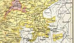
Jhalawar State [1] was a princely state in India during the British Raj. It was located in the Hadoti region. The main town in the state was Jhalawar.
The state belonged to the Kotah-Jhalawar Agency which had headquarters at Kota and was a subdivision of the Rajputana Agency.[2]
History
Background
The former ruling family of Jhalawar belonged to the Jhala clan of Rajputs. Their ancestors were the rulers of Halvad (later known as Dhrangadhra) in Kathiawar, and the family share lineage with numerous princely families of Kathiawar, including Wadhwan.
About 1709, after a bout of internecine bloodshed, Bhavsingh, one of the younger sons of the ruler of Halvad, left his native country with his family to try his fortune elsewhere. Those were the days of the Mughal empire, when many enterprising Rajputs made their fortune in the service of the empire, and Bhavsingh made his way to Delhi. Here he achieved only moderate success but made some important connections. Bhavsingh was able to arrange for his daughter to marry Arjun Singh, the Raja of Kota. Bhavsingh's fourth son, Madhu Singh, became a close friend and confidant of his brother-in-law, the Raja of Kota, to the extent that the Raja gave his sister in marriage to Madhu Singh, and prevailed upon him to move to Kota and take up an important position at his court. As was usual in that milieu, the position bestowed upon Madhu Singh became hereditary in his family, and they thus became members of the higher aristocracy of Kota state.
Founding
In 1771, a subsequent Raja of Kota died, leaving an infant as his heir, and the regency was settled upon Zalim Singh, a descendant of Madhu Singh. From that time, Zalim Singh became effectively the real ruler of Kota. He did not surrender power eb=ven when his young charge came of age, and contiuned to rule the state, effortlessly dominating the raja of Kota and reducing him to the status of a virtual non-entity. Unfortunate as this circumstance was, it is also true that Zalim Singh was an outstanding administrator and an astute negotiator. Under his administration, which lasted for over forty-five years, the state attained an acme of prosperity and was well-regarded by all its neighbours.[3] It was also during these years that Kota entered into treaty relations with the British; Zalim Singh established excellent personal relations with the British, and perhaps his shining reputation owes as much to the good opinion the British had of him as to his actual achievements on the ground.
The flip side of these achievements was that Zalim Singh himself attained a status of respectability exceeding that of his nominal overlord, the young Raja of Kota, and enjoyed leverage with the British that the Raja of Kota did not. It is due above all to this influence with the British that it was resolved in 1838, with the grudging consent of the chief of Kota, to dismember the state and create a new principality, which would be ruled by the descendants of Zalim Singh. Whereas for many decades, the family of Zalim Singh had held large estates in fief of the state of Kota, and held important positions at court, they were now to be invested with royalty and become the rulers of their own state. The state of Jhalawar was created in this manner, and it received its name in honour of the fact that Zalim Singh belonged to the Jhala clan of Chandravanshi Rajputs. The districts thus severed from Kotah represented one-third (£120,000) of the income of Kotah; by treaty, the new royal family acknowledged the suzerainty of the British and agreed to pay an annual tribute of £8000. Madan Singh, heir of Zalim Singh, received the title of Maharaja Rana, and was placed on the same footing as the other chiefs in Rajputana.
Maharaja Madan Singh, first ruler of independent Jhalawar, died in 1845.[3] An adopted son of his successor took the name of Zalim Singh in 1875 on becoming chief of Jhalawar. He was a minor and was not invested with governing powers till 1884. Owing to his maladministration, his relations with the British government became strained, and he was finally deposed in 1896, "on account of persistent misgovernment and proved unfitness for the powers of a ruling chief." He went to live at Varanasi, on a pension of £2,000 and the administration was placed in the hands of the British resident.[3]
After much consideration, the British resolved in 1897 to break up the state, restoring the greater part to Kota, but forming the two districts of Shahabad and the Chaumahla into a new state of area 810 square miles (2,100 km2), which came into existence in 1899, and of which Kunwar Bhawani Singh, a descendant of the original Zalim Singh, was appointed chief. The population of the state was 90,175 in 1901, with an estimated revenue of £26,000 and a tribute of £2000.[3]
Rulers
The Jhala clan of Rajputs are still regarded as the rulers of Jhalawar state and thus maintain a large majority of their power over Jhalawar. They were entitled to a 17 gun salute by the British authorities.[4]
| 8 Apr 1838 – 1845 | Madan Singh | (b. 1808 – d. 1845) |
| 1845 – 29 Aug 1875 | Prithvi Singh | (b. 1830 – d. 1875) |
| 29 Aug 1875 – 2 Mar 1896 | Zalim Singh | (b. 1865 – d. 1912) |
| 29 Aug 1875 – 21 Feb 1884 | Regent | |
| 2 Mar 1896 – 1 Jan 1899 | interregnum | |
| 1 Jan 1899 – 13 Apr 1929 | Bhawani Singh | (b. 1874 – d. 1929) (from 26 Jun 1908, Sir Bhawani Singh) |
| 13 Apr 1929 - 2 Sep 1943 | Rajendra Singh | (b. 1900 – d. 1943) (from 9 Jun 1938, Sir Rajendra Singh) |
| 2 Sep 1943 – 15 Aug 1947 | Harisch Chandra Singh | (b. 1921 – d. 1967) |
See also
References
- ↑ Imperial Gazetteer of India, v. 23, p. 51
- ↑ Imperial Gazetteer of India vol. IV 1907, pp. 94–95
- 1 2 3 4

- ↑ Jhalawar Princely State (17 gun salute)
![]()