Malerkotla State
| Maler Kotla State ਮਲੇਰਕੋਟਲਾ ਰਿਆਸਤ مالیرکوٹلہ رِیاست | |||||
| Princely State of British India | |||||
| |||||
 | |||||
| Motto Heaven's Light Our Guide[1] | |||||
 | |||||
| Capital | Malerkotla | ||||
| History | |||||
| • | Established | 1657 | |||
| • | Independence of India | 1948 | |||
| Area | |||||
| • | 1901 | 433 km2 (167 sq mi) | |||
| Population | |||||
| • | 1901 | 77,506 | |||
| Density | 179 /km2 (463.6 /sq mi) | ||||
| Today part of | Punjab, India | ||||
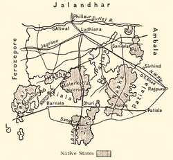
The State of Malerkotla or Maler Kotla(Urdu: رِیاست مالیرکوٹلہ ) was a princely state in the Punjab region during the era of British India. The last ruler of Maler Kotla signed the accession to join the Indian Union on 20 August 1948. Its rulers belonged to a Pathan, dynasty and its capital was in Malerkotla. The state belonged to the Punjab States Agency.
During the partition of India, The last Nawab Iftkhar Ali Khan remained in Maler Kotla & died in the year 1982. He is buried at Shahi grave yard situated at Sirhandi gate. However a part of the ruling family of Malerkotla State migrated to Pakistan and their members are living mostly in Model Town, Lahore, as well as in Muzaffargarh and Khangarh.[2]
History
The predecessor state was founded in 1454 A.D. by Sheikh Sadruddin-i-Jahan, a pious man of the Sherwani tribe of Afghanistan area, and was ruled by his descendents.[3]
Local tradition says that Behlol Lodhi (1451–1517), the Afghan king who had most of western India under his control, desired to rule Delhi and on his way he was caught in a sand drift.[4] In the darkness the King spotted a dim light of a lamp still burning in the wind. It was the hut of Sheikh Sadruddin and when the king found out he came to the hut to show his respect and asked the holy man to pray for him to bear a son and have victory.[4] During 1451 and 1452, the king married off his daughter Taj Murassa to Shaikh Sadruddin after being enthroned in Delhi, and also gave him the area of Malerkotla as a jagir.[4] The descendents of Shaikh Sadruddin branched into two groups. One started ruling the state and were given the title of Nawab.[4] The other branch lived around the Shrine of Shaikh Sadruddin, controlling its revenue.[4]
The State of Malerkotla was established in 1657 by Bayazid Khan. After saving the life of Mughal Emperor Aurangzeb in a tiger attack, Bayazid Khan was granted the privilege to build a fort, which he named Malerkotla and eventually gave its name to the state. On 3 May 1809 Maler Kotla became a British protectorate and was made part of the Cis-Sutlej states until 1862. Malerkotla ranked 12th in the Punjab Darbar in 1890. It is noteworthy that during the 1947 riots when Punjab was in flames, the State of Malerkotla did not witness a single incident of violence; through it all, it remained a lone island of peace.[3][5]
The roots of communal harmony in the area date back to 1705, when Sahibzada Fateh Singh and Sahibzada Zorawar Singh, 9 and 7 year old sons of 10th Sikh Guru, Guru Gobind Singh, were ordered to be bricked alive by the governor of Sirhind, Wazir Khan. His close relative, Sher Mohammed Khan, Nawab of Malerkotla, who was present in the court, lodged vehement protest against this inhuman act and said it was against Islam. Wazir Khan nevertheless had the Sahibzadas tortured and bricked into a section of wall while still alive. At this the Nawab of Malerkotla walked out of the court in protest. Guru Gobind Singh on learning this kind and humanitarian approach profusely thanked the Nawab of Malerkotla and blessed him with his Hukamnama, Kirpan etc. In recognition of this act, the State of Malerkotla did not witness a single incident of violence during partition.[3] Many local people attribute this peaceful strain to the presence of the shrine of 'Baba Haidar Sheikh', the Sufi saint, who founded the town of Malerkotla more than 500 years ago.[6][7]
Following Indian independence and the signing of the instrument of accession to the Indian Union in 1948, Maler Kotla joined the newly established state of Patiala and East Punjab States Union (PEPSU) until its merger with Punjab in 1956.
Rulers
The rulers were titled 'Nawab'. They had the right to an 11 gun salute.[8]
- 1672 - 1712 Sher Muhammad Khan Bahadur (b. 1640 - d. 1712)
- 1712 - 1717 Ghulam Husain Khan (d. 1734)
- 1717 - 1762 Jamal Khan (d. 1762)
- 1762 - 1763/64 Bhikan Khan (d. 1763/64)
- 1764 - 1766 Khan Sahib Khan Bahadur Khan (d. 1766) (ruled as regent 1762-1764)
- 1766 - 1 Nov 1780 Khan Sahib Umar Khan (d. 1780)
- 1 Nov 1780 - Apr 1784 Khan Sahib Asadullah Khan (d. 1784)
- Apr 1784 - 14 Aug 1809 Khan Ataullah Khan (d. 1809)
- 14 Aug 1809 - 4 Sep 1821 Muhammad Wazir `Ali Khan (b. 17.. - d. 1821)
- 4 Sep 1821 - 8 Apr 1846 Amir `Ali Khan Bahadur (d. 1846)
- 8 Apr 1846 – 25 Nov 1857 Mahbub `Ali Khan Bahadur (d. 1857) "Sube Khan"
- 25 Nov 1857 – 16 Jul 1871 Eskandar `Ali Khan Bahadur (d. 1871)
- 16 Jul 1871 – 23 Aug 1908 Mohammad Ebrahim `Ali Khan (b. 1857 - d. 1908)
- 16 Jul 1871 - 1875 .... - Regent rule
- 23 Aug 1908 – 15 Aug 1947 Ahmad `Ali Khan Sherwani (b. 1881 - d. 1947) (from 3 Jun 1915, Sir Ahmad `Ali Khan Sherwani) (ruled as regent 1 Feb 1905 – 23 Aug 1908)
See also
References
- ↑ The motto of the Order of the Star of India
- ↑ Malerkotla Muslims Archived 2 September 2009 at the Wayback Machine. The India Express, 14 August 1997.
- 1 2 3 Goyal, Sushil (19 August 2006). "'Malerkotla has Guru's blessings'". The Tribune. Retrieved 2013-03-24.
- 1 2 3 4 5 "Study of the Pathan Communities in four States of India". Khyber. Archived from the original on 14 May 2008. Retrieved 2007-06-07.
- ↑ A people's gratitude Archived 14 May 2008 at the Wayback Machine. The Sikh Review, Issue No. 14, November 2003
- ↑ The Legend of Malerkotla: A Tale from the Punjab (2004) 48 min, DVD, ISBN 978-0-8026-0761-4.
- ↑ Bigelow, Anna B (2 December 2000). "Malerkotla: A heritage going to seed". The Tribune. Retrieved 2013-03-24.
- ↑ States before 1947 K-Z
![]()