Maihar State
| Maihar State मैहर रियासत | |||||
| Princely State of British India | |||||
| |||||
 | |||||
| History | |||||
| • | Established | 1778 | |||
| • | Accession to the Union of India | 1948 | |||
| Area | |||||
| • | 1940 | 1,054 km2 (407 sq mi) | |||
| Population | |||||
| • | 1940 | 79,558 | |||
| Density | 75.5 /km2 (195.5 /sq mi) | ||||
| Columbia-Lippincott Gazetteer. p.1122 | |||||
Maihar State was a princely state in India during the British Raj. The state had an area of 1,050 square kilometres (407 sq mi), and a population of 63,702 in 1901. The state, which was watered by the Tons River, consists mainly of alluvial soil covering sandstone, and is fertile except in the hilly district of the south.[1] A large area was under forest, the produce of which provided a small export trade.[1]
History
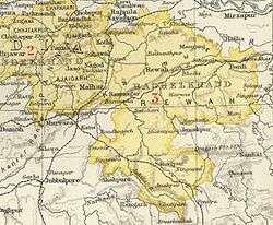
The state was founded in 1778 by Rajputs of the Kachwaha clan, who were granted land by the ruler of the nearby state of Orchha. From 1788 to 1790 Maihar State was occupied by Banda. The state became a princely state of British India in the early 19th century, and was administered as part of Bundelkhand Agency in the Central India Agency. In 1871 the eastern states of Bundelkhand Agency, including Maihar, were separated to form the new Bagelkhand Agency in Central India. In 1933 Maihar, along with ten other states in western Bagelkhand, were transferred back to the Bundelkhand Agency.[2]
The state suffered severely from famine in 1896–1897.[1] Maihar became a station on the East Indian Railway [1](now the West Central Railway) line between Satna and Jabalpur, 156 kilometres (97 mi) north of Jabalpur. Extensive ruins of shrines and other buildings surround the town.[1] As of 1940 it had a population of 79,558 and an area of 412 square miles. In 1948 Maihar was merged into India.
Rulers
Thakurs
- 1778 – 1788 Beni Singh (b. 1719 – d. 1788)
- 1788 – 1790 Rajdhar Singh (b. c.1765 – d. 1790)
- 1790 – 1825 Durjan Singh (b. 1766 – d. 1825)
- 1826 – 1850 Bishan Singh (b. 1797 – d. 18..)
- 1850 – 1852 Mohan Prasad (b. 1816 – d. 1852)
- 1852 – 1869 Raghubir Singh (b. 1843 – d. 1908)
- 1852 – 1865 .... -Regent
Rajas
- 1869 – 1908 Raghubir Singh (s.a.)
- 1908 – 7 Jan 1910 Jagubir Singh (b. 1864 – d. 1910)
- 7 Jan 1910 – 15 Dec 1911 Randhir Singh (b. 1865 – d. 1911)
- 16 Dec 1911 – 15 Aug 1968 Brijnath Singh (b. 1896 – d. 1968)
- 15 Aug 1968 – Narayan Singh
References
- 1 2 3 4 5

- ↑ Maihar (Princely State)