Khanate of Kalat
| Khanate of Kalat خانات ءِ قلات | |||||||||
|---|---|---|---|---|---|---|---|---|---|
| 1666–14 October 1955 | |||||||||
 Flag | |||||||||
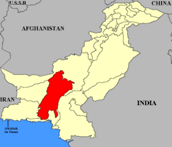 Map of Pakistan with Kalat highlighted | |||||||||
| Capital | Kalat | ||||||||
| Common languages | Persian, Brahui | ||||||||
| Government |
Monarchy Princely state | ||||||||
| History | |||||||||
• Established | 1666 | ||||||||
• Disestablished | 14 October 1955 | ||||||||
| Area | |||||||||
| 91,909 km2 (35,486 sq mi) | |||||||||
| |||||||||
| Today part of | Balochistan, Pakistan | ||||||||
.jpg)
 |
| This article is part of the series |
| Former administrative units of Pakistan |
|---|
|
One-unit provinces |
|
Other subdivisions |
The Khanate of Kalat (Balochi: خانات ءِ قلات) was a princely state that existed from 1666 to 1955 in the centre of the modern-day province of Balochistan, Pakistan. Prior to that they were subjects of Mughal emperor Akbar.[1][2] Ahmedzai Baloch and Brahui Khan ruled the state independently until 1839, when it became a self-governing state in a subsidiary alliance with British India. After the signature of the Treaty of Mastung by the Khan of Kalat and the Baloch Sardars in 1876, Kalat became part of the Baluchistan Agency.[3] It was briefly independent from August 1947 till March 1948, when its Khan acceded his state to the new Dominion of Pakistan. It remained a princely state of Pakistan until 1955, when it was incorporated into the country.
Geography
The Khanate of Kalat occupied the central part of the territory of modern-day Balochistan province in Pakistan. To the north was Baluchistan (Chief Commissioner's Province).
The principal mountains are the Central Baloch, Kirthar, Pab, Siahan, Central Makran and Makran Coast Ranges, which descend in elevation from about 10,000 to 1,200 feet (370 m). The drainage of the country is almost all carried off to the south by the Nari, Mula, Hab, Porali, Hingol and Dasht rivers. The only large river draining northwards is the Rakhshan. The coast line includes Gawadar, Pasni, Sonmiani and Geewani, modern-day Pakistani Balochistan.
Subdivisions
An ethnic Brahui sub division of kalat headed by chief nawab of zarakzai tribe called chief of jhalawan
An ethnic Sindhi sub division of kalat in which various tribes have their own tribal lands under the khan of kalat
An ethnic Baloch sub division of kalat headed by chief nawab of raisani tribe called chief of sarawan
Independent States under British Protectorate
An Makrani state of of Gichki Tribe of the Baloch ruled by Chief Nawab called nawab of makran
The state ruled by hereditary rulers of Las Bela styled as Jam Sahib. The Samma Dynasty took the title of Jam, the local equivalent of "King" or "Sultan". Samma Dynasty belongs to sindhi chapter historically they speak sindhi language
A Baloch state led by the Rakhshani tribal confederation ruled by the chief nawab of Nausherwani tribe called Nawab of Kharan
A Makrani coastal state of Baloch people headed by an appointed Arab governor under the direct rule of Sultanate of Muscat and Oman
History
According to Ta'rikh-i ihyae al-muluk, at the end of the 16th century the Kelat region (former Turan ) was under the control of the Safavids, but at the beginning of the 17th century the Baluchi tribe of Lashari stood up against the Sistan Khan and the Kermanian Beg, and took control of Turan and Makran, until the Kelat Khanate appeared.[4] The Khanate of Kalat was founded in 1666 by Mir Ahmad Khan Qambrani Baloch. The Khanate reached at its peak during the period of Khan of Kalat Mir Naseer Khan Noori Ahmadzai a Brahui speaking khan I in 1758, who unified Kalat region under his flag.[5] The territories controlled by the state fluctuated over the centuries but eventually were established by treaties with the British Agent Robert Sandeman in the late 19th century. Parts of the state to the north and northeast were leased or ceded to form the province of British Baluchistan which later gained the status of a Chief Commissioners province.
From 15 August 1947 to 27 March 1948, the region was de facto independent before acceding to Pakistan on 27 March 1948. The Baluchistan States Union was formed on 3 October 1952 with three neighbouring states. The Khanate of Kalat ceased to exist on 14 October 1955 when the province of West Pakistan was formed.
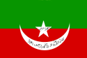
The khanate of Kelat had a flag green over red. In the center occupying the red part and a little part of the green, a large white crescent pointed upwards and a white star (the star exactly in the center of the two stripes). Within the star and crescent an Islamic inscription. On the star there is a maxim: "God is the Greatest" and on the crescent moon the inscription says: "There is no deity but God and Muhammad is His Messenger". All of this is placed on the horizontal bicolor of green over red. These are colors to which Muslim Baluch assign great significance.[6]
Rulers of Kalat
The rulers of Kalat held the title of Wali originally but in 1739 also took the title (Begler Begi) Khan usually shortened to Khan. The last Khan of Kalat (Balochi: خان قلات) had the privilege of being the President of the Council of Rulers for the Baluchistan States Union.
| Tenure | Khan of Kalat [5] |
|---|---|
| 1512–1530 | Mir Bijar Khan Mirwani |
| 1530–1535 | Mir Zagar Khan Mirwani |
| 1535–1547 | Mir Ibrahim Khan Qambrani ( Changed his Royal family name from Mirwani to Qambrani ) |
| 1547–1549 | Mir Gwahram Khan Qambrani |
| 1549–1569 | Mir Hassan Khan Qambrani |
| 1569–1581 | Mir Sanjar Khan Qambrani |
| 1581–1590 | Mir Malook Khan Qambrani |
| 1590–1601 | Mir Qambar Sani Khan Qambrani |
| 1601–1610 | Mir Ahmad Khan Qambrani I |
| 1610–1618 | Mir Suri Khan Qambrani |
| 1618–1629 | Mir Qaisar Khan Qambrani |
| 1629–1637 | Mir Ahmad Sani Khan Qambrani II |
| 1637–1647 | Mir Altaz Khan Qambrani I |
| 1647–1656 | Mir Kachi Khan Qambrani |
| 1656–1666 | Mir Altaz Sani Khan Qambrani II |
| 1666–1695 | Mir Ahmad I Khan Qambrani III ( Changed his Royal family name from Qambrani to Ahmadzai ) |
| 1695–1697 | Mir Mehrab Khan Ahmadzai I |
| 1697–1714 | Mir Samandar Khan Ahmadzai ( Amir al-Umara Amir of Amirs) |
| 1714–1716 | Mir Ahmad II Khan Ahmadzai |
| 1716–1731 | Mir Abdullah Khan Ahmadzai ( Eagle of the Mountain and The Greatest ) |
| 1731–1749 | Mir Muhabbat Khan Ahmadzai ( Beglar Begi ) |
| 1749–1794 | Mir Muhammad Nasir Khan I Ahmadzai ( Noori, Ghazi, Wali and The Great ) |
| 1794–1817 | Mir Mahmud Khan I Ahmadzai |
| 1817–13 November 1839 | Mir Mehrab Khan Ahmadzai II |
| 1839–1841 | Mir Shah Nawaz Khan Ahmadzai |
| 1841–1857 | Mir Nasir Khan II Ahmadzai |
| 1857–March 1863 | Mir Khudadad Khan Ahmadzai (1st time); during his rule, there were seven major and many minor rebellions. |
| March 1863–May 1864 | Mir Sherdil Khan Ahmadzai (usurped throne) |
| May 1864–15 August 1893 | Mir Khudadad Khan (2nd time) |
| 10 November 1893 – 3 November 1931 | Mir Mahmud Khan II Ahmadzai |
| 3 November 1931 – 10 September 1933 | Mir Mohammad Azam Jan Khan Ahmadzai |
| 10 September 1933 – 14 October 1955 | Mir Ahmad Yar Khan Ahmadzai (1st time); declared independent on 5 August 1947; agreed to accede to Pakistan on 30 March 1948 |
| 14 October 1955 | State of Kalat merged into One Unit of West Pakistan[7] |
| 20 June 1958 – 1979 | Mir Ahmad Yar Khan Ahmadzai |
| 1979–1998 | Mir Dawood Jan Ahmadzai |
| 1998–2006 | Mir Agha Sulaiman Jan Ahmadzai |
| 2006–present | Prince Mir Mohammad Khan Ahmadzai |
See also
_(14782070024).jpg)
References
- ↑ Treaty of Kalat between Balochistan and Afghanistan in 1758
- ↑ "Baluchistan" Imperial Gazetteer of India Vol. 6, p. 277, from the Digital South Asia Library, accessed 15 January 2009
- ↑ Balochistan Archives - Records of the Agent to the Governor General in Balochistan
- ↑ "Восточная Литература - библиотека текстов Средневековья". www.vostlit.info. Retrieved 2018-07-16.
- 1 2 Naseer Dashti (8 October 2012). The Baloch and Balochistan: A Historical Account from the Beginning to the Fall of the Baloch State. Trafford Publishing. p. 280. ISBN 978-1-4669-5897-5. Retrieved 6 August 2013.
- ↑ http://www.crwflags.com/fotw/flags/in-kalat.html
- ↑ Siddiqi, Farhan Hanif (2012), The Politics of Ethnicity in Pakistan: The Baloch, Sindhi and Mohajir Ethnic Movements, Routledge, p. 62, ISBN 978-0-415-68614-3
Further reading
- Siddiqi, Farhan Hanif (2012), The Politics of Ethnicity in Pakistan: The Baloch, Sindhi and Mohajir Ethnic Movements, Routledge, ISBN 978-0-415-68614-3
External links
- Swidler, N. (1972) "The Development of the Kalat Khanate" Journal of Asian and African Studies 7: pp. 115–21
- Swidler, N. (1992). Kalat: The Political Economy of a Tribal Chiefdom. American Ethnologist, 19(3), 553-570
- Kalat District - Planning and Development Department of Balochistan Government
- Genealogy of the Khans of Kalat
Coordinates: 29°01′33″N 66°35′24″E / 29.02583°N 66.59000°E