Sant State
| Sant State સંત રિયાસત | ||||||
| Princely State of British India | ||||||
| ||||||
| ||||||
 | ||||||
| History | ||||||
| • | Established | 1255 | ||||
| • | Accession to the Union of India | 1948 | ||||
| Area | ||||||
| • | 1901 | 1,020 km2 (394 sq mi) | ||||
| Population | ||||||
| • | 1901 | 59,351 | ||||
| Density | 58.2 /km2 (150.7 /sq mi) | |||||


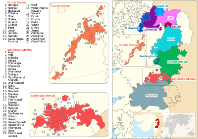
Santrampur State covered an area of approximately 1,365 sq km and was situated in the northeast of Rewa Kantha Agency. It was bounded on the north by the dominions of Dungarpur and Banswara in Rajputana. On the east was the sub division of Jhalod in the Panch Mahals. On the south it touched the small state of Sanjeli while on the west it was bounded by the State of Lunavada. The state enjoyed a hereditary salute of 9 guns and 11 gun local salute.
History
The rulers of Santrampur are Parmar Rajputs. They claim descent from the Mahipavat branch of the famous Malwa dynasty. They belong to the lineage from Vikramaditya emperor of Ujjain, much known for his wisdom, bravery and magnanimity, and Raja Bhoj who ruled Malwa in the 11th century AD. According to the bards, Jalamsinh left Ujjain and came to the northeast part of present day Gujarat and founded the town of Jhalod around 1010 AD. He was succeeded by Jhajsinghji, Bikamsinghji, Udaysinghji, Pratapsinghji and Jalamsinghji II. Jalamsinghji II was defeated in 1247 by Islamic invaders; his son Sant and brother Limdevji were the only two survivors left of this house along with a handful of their retainers. Moving ever westwards, wandering in the forests, they finally carved out a kingdom for themselves in 1255 and named it Sant or Sunth.[1]
So, the state was founded in 1255 and named after its founder i.e. Sant. It had its capital in Santrampur (Sant-Rampur).[2] It was granted a Hereditary 9 gun salute and belonged to the Rewa Kantha Agency of the Bombay Presidency.[3][4]
In 1913, the state was rocked by an adivasi (Bhil) uprising led by Guru Govindsinh.[5] Its last ruler signed the accession to the Indian Union on 10 June 1948, [6] by which it ceased to exist, merging into Gujarat, and was assigned a Privy purse of 112,000 Rupees.
Rulers
| Princely state |
|---|
| Individual residencies |
| Agencies |
|
| Lists |
The rulers of Sant belonged to the Powar or Parmar Rajput dynasty, believed to have originated in Ujjain.[5] The founder of the family was an individual named Sant, who established himself at Sunth in about the 13th century.[5] The rulers of the state were styled Rana. (equivalent to Raja from ca 1870 onward)[7]
- Sant
- Navaghanji Sant
- Napuji Navghanji
- Parithisinhji I Napuji
- Suraji Parithisinhji
- Jaisinhji Suraji
- Kumbha Rano Jaisinhji
- Ramsinhji Kumbha
- Raimalji Ramsinhji
- Mandlikji Raimalji
- Surajmalji Mandlikji
- Ratansinhji I Surajmalji
- Prithisinhji II Ratansinhji
- Gajsinhji I Prithisinhji
- 1688 – 1705 Mahusinhji
- 1705 – 1735 Prithisinhji II Mahusinhji
- 1735 – 1753 Ratansinhji II Prithisinhji (d. 1753)
- 1753 – 1774 Badansinhji Ratansinhji (d. 1774)
- 1774 – 1803 Shivsinhji Badansinhji
- 1803 – 1819 Keshrisinhji Shivsinhji (d. 1819)
- 1819 Gajsinhji II Keshrisinhji (d. 1819)
- 1819 – 1835 Kalyansinhji Shivsinhji (d. 1835)
- 1835 – 1872 Bhawansinhji Kalyansinhji (b. 1832 – d. 1872)
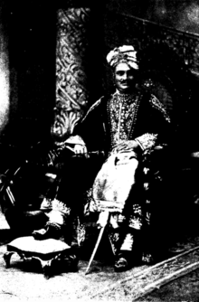
- 17 April 1873 – 10 January 1896 Pratapsinhji Bhawansinhji (b. 1860 – d. 1896)
- 31 August 1896 – death 22 Dec 1946 Zorawarsinhji Pratapsinh (born 1881 – d. 1946)
- 22 December 1946 – 15 August 1947 Pravinsinhji Zorawarsinhji (b. 1907 – d. 1948)
The line is nominally continued.
See also
References
- ↑ Chakrabarti, Jadab Chandra (1895). The Native States of India. Calcutta: S.K. Shaw. p. 239.
- ↑ Blair, G.W. (1906). Station and Camp Life in the Bheel Country. Belfast: Graham & Heslip. pp. 121–122.
- ↑

- ↑ Sant Princely State (9 gun salute)
- 1 2 3 Parmar, Ladhabhai Harji (1922). The Rewakantha Directory. Rajkot: Parmar Press. p. 53.
- ↑ Princely States of India K-W
- ↑ Sant (Princely State)
External links and sources
Coordinates: 23°11′22″N 73°53′34″E / 23.18947°N 73.8928°E