Sirohi State
| Sirohi State | ||||||
| Princely State of British India | ||||||
| ||||||
| ||||||
 | ||||||
| History | ||||||
| • | Established | 1405 | ||||
| • | Independence of India | 1949 | ||||
| Area | ||||||
| • | 1931 | 5,164 km2 (1,994 sq mi) | ||||
| Population | ||||||
| • | 1931 | 216,528 | ||||
| Density | 41.9 /km2 (108.6 /sq mi) | |||||
| Today part of | Rajasthan, India | |||||
| [1] | ||||||


Sirohi was an Indian princely state in pre-independence India with its capital at Sirohi. The state lost its independence and became a British protectorate in 1823 when it was subsumed into the British Raj. Shortly after Indian independence in 1947, Sirohi state was merged with the Rajasthan State on 16 November 1949 and its existence came to an end.
Geography
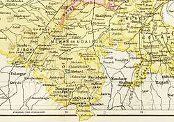
Sirohi State was in the Rajputana agency. It had an area 1,964 square miles (5,090 km2) The territory was much broken up by hills and rocky ranges; the Aravalli range divided it into two portions, running from north-east to south-west. The south and south-east part of the territory is mountainous and rugged, containing the lofty Mount Abu, an isolated mass of granite rock, culminating in a cluster of hills, enclosing several valleys surrounded by rocky ridges, like great hollows. On both sides of the Aravallis the country is intersected with numerous water channels, which run with considerable force and volume during the height of the rainy season, but are dry for the greater part of the year. The only river of any importance is the Western Banas.[2]
In 1911 the Encyclopædia Britannica Eleventh Edition recorded that a large portion of the state was covered with dense jungle, in which wild animals, including the tiger, bear and leopard, abounded; and that the climate was on the whole dry (in the south and east there was usually a fair amount of rain. On Abu the average annual rainfall is about 64 inches (160 cm), whereas in Erinpura, less than 50 miles (80 km) to the north, the average fall is only between 12 and 13 inches (30 and 33 cm).[2]
During the 19th century the Rajputana Railway was built. It traversed the state, and a station was built at Abu Road, 28 miles (45 km) south of the town of Sirohi.[2]
In 1901 the population of the state was 154,544, showing a decrease of 17% in the decade, due to the results of famine. Gross revenue was £28,000, tribute to the British Raj was £450. The population of the town of Sirohi was 5,651 and its main business was the manufacturing of sword-blades and other weapons.[2]
History
In 1405, Deora king Rao Sobhaji a descendant of the Nadole ruler Samantsi Songara of Chauhan clan founded the town of Shivpuri on the western slope of Siranwa Hill. Shivpuri today lies in ruins. In 1425, his son and successor, Sehastramal (or Sahastramal, Sehastramal), founded a fortress on the eastern slope of the same hill, which became his capital and grew into the present-day town of Sirohi.[3]
Rao Surtan of Sirohi defeated the army of Mughal emperor Akbar in the famous battle of Dattani. Nandia come in sirohi scientist proved that the lord Krishna got married hear it has a beautiful fort named ऋषीश्वर temple Sirohi State used to issue its own postage stamp, and even coins for some years, which are now rare.
During the early years of the 19th century, Sirohi suffered much from wars with Jodhpur and the hill tribes of the area. The protection of the British was sought in 1817; the pretensions of Jodhpur to suzerainty over Sirohi were disallowed, and in 1823 a treaty was concluded with the British government. Sirohi became a self-governing princely state within British India, and part of the Rajputana Agency.[2]
For services rendered during the Revolt of 1857, the Rao received a remission of half his tribute. Rao Keshri Singh (ruled 1875-1920) and his successors were granted the title Maharao (equivalent to Maharaja) in 1889.[2]
Rao Keshari Sing loved his both wives Rani Gulab and Rani Krishna.. So he founded two villages in the Sirohi constituency named Gulabganj & Krishnaganj respectively to show their Heartily love towards their wives.. The both villages still occurs in Sirohi region and among them Krishnaganj have a great importance weather religious or political means in the Sirohi region.. When India became independent in 1947, it was agreed that the princely states would lose the independence that they had held and that the states would be integrated into the central administration. Sirohi state was merged with the Rajasthan State on 16 November 1949 and its it ceased to exist as a separate entity.[3]
Rulers
Raos
- 1697 – 1705: Durjan Singh (d. 1705)
- 1705 – 1749: Umaid Singh I (Man Singh II) (b. c.1685 – d. 1749)
- 1749 – 1773: Prithvi Singh (d. 1773)
- 1773 – 1781: Takhat Singh (d. 1781)
- 1773 – 1781: Jagat Singh – Regent (d. 1782)
- 1781 – 1782: Jagat Singh (s.a.)
- 1782 – 1808: Verisalji II (Bairi Sal II) (b. 1760 – d. 1809)
- 1808 – 11 Jan 1847: Udaibhan Singh (d. 1847)
- 1819 – 11 Jan 1847: Sheo Singh – Regent (d. 1862)
- 11 Jan 1847 – 8 Dec 1862: Sheo Singh (s.a.)
- Nov 1861 – 8 Dec 1862: Umaid Singh – Regent (b. 1833 – d. 1875)
- 8 Dec 1862 – 16 Sep 1875: Umaid Singh II (s.a.)
- 16 Sep 1875 – 1 Jul 1889: Keshri Singh (b. 1857 – d. 1925)
Maharaos
- 1 Jul 1889 – 29 Apr 1920: Keshri Singh (s.a.) (from 1 Jan 1895, Sir Keshri Singh)
- 29 Apr 1920 – 23 Jan 1946: Sarup Ram Singh (b. 1888 – d. 1946) (from 3 Jun 1924, Sir Sarup Ram Singh)
- 5 May 1946 – 15 Aug 1947: Tej Ram Singh (b. 1943)
- 5 May 1946 – 15 Aug 1947: Maharani Krishna (d. 1979) Kunverba (f) – Regent
Revenue system
The traditional practice of revenue collection consisted of bhog batai and halbandi. Bhog batai, the more prevalent practice, consisted of direct collection of a part of the harvested produce by the state. In some areas of the state, halbandi was used, under which a cash tax was imposed on the implements used by farmers. In 1904, a new revenue-collection system was introduced which consisted of revenue collection based on average productivity of the cultivated area as the criterion for payment. From the state's perspective, the new revenue system was largely successful, leading to a large increase in the state's revenue.[4]
References
- ↑ Sirohi (Princely State)
- 1 2 3 4 5 6 Chisholm 1911, p. 257.
- 1 2 DS staff 2011, History.
- ↑ Vidal, Denis (1997). Violence and Truth: A Rajasthani Kingdom Confronts Colonial Authority. Delhi: Oxford University Press. pp. 69–71. ISBN 9780195641059.
External links
