Idar State
| Idar State | ||||||
| Princely State of British India | ||||||
| ||||||
| ||||||
| History | ||||||
| • | Established | ca 1257 | ||||
| • | Indian independence | 1948 | ||||
| Area | ||||||
| • | 1901 | 4,323 km2 (1,669 sq mi) | ||||
| Population | ||||||
| • | 1901 | 168,557 | ||||
| Density | 39 /km2 (101 /sq mi) | |||||
| Today part of | India | |||||

Idar State [1] or Edar, was a princely state of India during the time of the British Raj. It was the most important state of the Mahi Kantha Agency, within the Gujarat Division of Bombay Presidency.[2]
Idar State had an area of 1669 km², and a population (1901) of 168,557, showing a decrease of 44% in the decade as the result of famine. The estimated gross revenue was £29,000 and the tribute to the gaekwar of Baroda, £2000. In 1901 the raja and his posthumous son both died, and the succession devolved upon Pratap Singh of Idar of Jodhpur.[2][3]
The line of railway from Ahmedabad through Prantij runs mainly through this state. Much of the territory is held by kinsmen of the raja on feudal tenure. The products are grain, oil-seeds and sugar-cane. The town of Idar is 64 m. N.E. of Ahmedabad. Pop. (1901) 7085. It was formerly the capital, but Ahmednagar[2] (to the east of Himatnagar, pop. 3200) became the capital by the end of the British Raj.
In 1941 Idar had a population of 307,798.[4]
History
Idar State was founded in the 13th century and was ruled by Rao Rajputs. In 1791, it was split into five states: Idar, Ahmadnagar, Modasa, Bayad and Soor (Sur). In 1821, Modasa was absorbed by Ahmadnagar. In 1826, Bayad absorbed by Idar and Ahmadnagar. In 1843, Idar was reunited.[5]
In 1924 Idar was made part of the Western India States Agency. It was transferred to the Rajputana Agency in the early 1940s. On 10 June 1948 Idar became part of the Indian Union. In 1949 it was dissolved and split between Sabar Kantha district and Mehsana district which were at that point in Bombay State.[4] Both these districts were included in Gujarat when it was formed in 1960.
Rulers of Idar
The rulers of Idar were a branch of the Rathore dynasty and thus of the same lineage as the Ruler of Jodhpur. The first Maharaja was the son of Ajit Singh of Jodhpur.
Rajas
- 1731 – 1751: Rao Anand Singh ( – 1753)
- 1751 – 1791: Shiv Singh (1736 – 1791), His second son founded a separate branch of the dynasty, which ruled as Maharajas of Ahmednagar from 1792 until 1843, when Takht Singh, the last Maharaja, became Maharaja of Jodhpur and continued the Ahmednagar line from there.
- 1791 – 1792: Bhawani Singh (1755 – 1792)
- 1792 – 1833: Gambhir Singh (1781 – 12 August 1833) death of umedsinh (Died in his fathers' lifetime)
- 12 August 1833 – 26 December 1868: Jawan Singh, KCSI (1830 – 26 December 1868)
- 26 December 1868 – February 1901: Keshri Singh, KCSI (1864 – February 1901)
- Interregnum from February to October 1901
- October – 30 November 1901: Krishna Singh (October 1901 – 30 November 1901). A posthumous son of Sir Keshrisinhji, who "ruled" from his birth, eight months after his father's death, to his own death a month later.
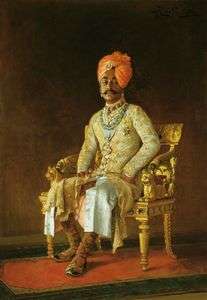
- January 1902 – 1902: Maharaja Sri Sir Pratap Singh, GCB, GCSI, GCVO, LLD (22 October 1845 – 4 September 1922)
Maharajas
- 1902 – May 1911: Pratap Singh, GCB, GCSI, GCVO, LLD (22 October 1845 – 4 September 1922)
- May 1911 – 14 April 1931: Daulat Singh, KCSI (12 May 1875 – 14 April 1931)
- 14 April 1931 – 15 August 1947: Himmat Singh, (2 September 1899 – 24 November 1960)
Post-Independence Maharajas
- Daljit Singh (10 July 1917 – 17 May 1992)
- Rajendra Singh (25 September 1938 – )
Rajas of Ahmadnagar
- 1791 – 1798: Sangram Singh
- 1798 – 1835: Karan Singh
- 1835 – 1839: Prithvi Singh
- 1839 – 1841: ...
- 1841 – 1843: Takht Singh
Rajas of Morasa
- 1791 – 1806: Zalim Singh
- 1806 – 1821: Pratap Singh
Rajas of Baad
- 1791 – 1826: Amir Singh
Rajas of Soor
- 1791 – Indra Singh
Genealogy
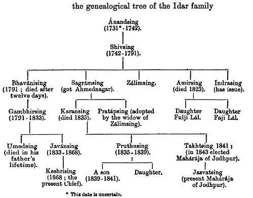 Genealogical tree of Idar State royal family, as of 1900 |
References
- ↑ Imperial Gazetteer of India - Idar State
- 1 2 3

- ↑ Idar State
- 1 2 Columbia-Lippincott Gazetteer, p. 824
- ↑ Rajput Provinces of India - Idar State (Princely State)
External links

Coordinates: 23°49′48″N 73°00′00″E / 23.83000°N 73.00000°E