Kalahandi State
| Kalahandi State Karond State | ||||||
| Princely State of British India | ||||||
| ||||||
| ||||||
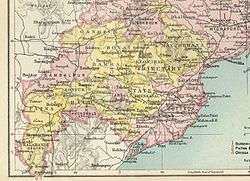 | ||||||
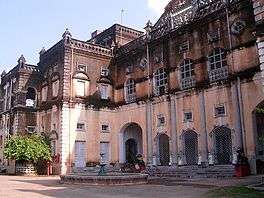
| Capital | Bhawanipatna | |||||
| History | ||||||
| • | Established | 1005 | ||||
| • | Accession to the Union of India | 1948 | ||||
| Area | ||||||
| • | 1892 | 9,700 km2 (3,745 sq mi) | ||||
| Population | ||||||
| • | 1892 | 224,548 | ||||
| Density | 23.1 /km2 (60 /sq mi) | |||||
| Today part of | Odisha, India | |||||


Kalahandi State, also known as Karond State,[1] was one of the princely states of India during the period of the British Raj. It was recognized as a state in 1874[2] and had its capital in Bhawanipatna. Its last ruler signed the accession to the Indian Union on 1 January 1948.
History
Kalahandi was the largest of the 26 Feudatory states of Odisha. According to local tradition the state originated with Raja Raghunath Sai of the Naga dynasty beginning to rule the Kalahandi area in 1005, therefore the state's coat of arms had two cobras facing each other.[3]
In August 1947 Kalahandi became part of the Eastern States Union, an entity that was formed in Rajpur and that gathered most of the princely states of Orissa and Chhattisgarh. The Eastern States Union was dissolved in 1948.[4] The formerly princely state's territory is now within Kalahandi District.
Rulers
The rulers of Kalahandi princely state belonged to the Nagavanshi clan and were granted a hereditary salute of 9 guns by the British.
Rajas
- 1005 - 1040 Raghunath Sai
- .......... (20 rajas)
- 1693 - 1721 Jugasai Deo III
- 1721 - 1747 Khadag Rai Deo
- 1747 - 1771 Raisingh Deo III
- 1771 - 1796 Purusottam Deo
- 1796 - 1831 Jugasai Deo IV
- 1831 - 1853 Fateh Narayan Deo
- 1853 - 7 Apr 1881 Udit Pratap Deo (b. 1839? - d. 1881)
- 7 Apr 1881 – 20 Oct 1897 Raghu Kesari Deo (b. 1871 - d. 1897)
- 20 Oct 1897 - 1926 Brij Mohan Deo (b. 1896 - d. 1939)
Maharajas
- 1926 - 19 Sep 1939 Brij Mohan Deo (s.a.)
- 19 Sep 1939 – 15 Aug 1947 Pratap Kishor Deo (b. 1919 - d. 2001)
See also
References
- ↑

- ↑ Indian Princely States
- ↑ Malleson, G. B. An historical sketch of the native states of India, London 1875, Reprint Delhi 1984
- ↑ Sadhna Sharma ed. States Politics in India, 1995, p. 273
External links

- Aftermath of Merger of Princely States in Orissa
Coordinates: 20°04′59″N 83°12′00″E / 20.083°N 83.2°E