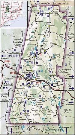
Berkshire County, Massachusetts
Berkshire County (pronounced /ˈbɜːrkʃər/) is a county on the western edge of the U.S. state of Massachusetts. As of the 2010 census, the population was 131,219.[2] Its largest city and traditional county seat is Pittsfield.[3] The county was founded in 1761.[4]
Berkshire County | |
|---|---|
| County of Berkshire | |
 Berkshire County Courthouse | |
 Seal | |
| Motto(s): Firmus et Paratus (Latin "Steadfast and Ready") | |
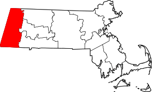 Location within the U.S. state of Massachusetts | |
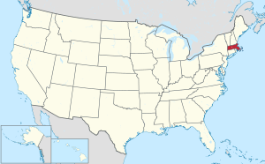 Massachusetts's location within the U.S. | |
| Coordinates: 42°23′46″N 73°12′36″W | |
| Country | |
| State | |
| Founded | April 24, 1761 |
| Seat | Pittsfield |
| Largest city | Pittsfield |
| Area | |
| • Total | 946 sq mi (2,450 km2) |
| • Land | 927 sq mi (2,400 km2) |
| • Water | 20 sq mi (50 km2) 2.1%% |
| Population | |
| • Estimate (2019) | 124,944 |
| • Density | 136/sq mi (53/km2) |
| Demonym(s) | Berkshirite[1] |
| Time zone | UTC−5 (Eastern) |
| • Summer (DST) | UTC−4 (EDT) |
| Congressional district | 1st |


The Berkshire Hills are centered on Berkshire County. Residents are known as Berkshirites. It exists today only as a historical geographic region, and has no county government, with the exception of the retirement board for former county workers, and certain offices such as the sheriff and registry of deeds.
Law and government
Of the fourteen Massachusetts counties, Berkshire County is one of eight that exists today only as a historical geographic region; it has limited county government. Berkshire County government was abolished effective July 1, 2000, most former county functions were assumed by state agencies, and there is no county council or commission.[5] The sheriff became a Commonwealth employee, but remains locally elected to perform duties within the county region and retains administrative and operational control over the Berkshire Sheriff's Office, an independent state agency created after the county government was abolished. The Berkshire Sheriff's Office runs the county jail and house of correction.[5]
Local communities were granted the right to form their own regional compacts for sharing services, and the towns of Berkshire County have formed such a regional compact known as the Berkshire Regional Planning Commission.
Berkshire County has three Registry of Deeds Districts, one for each district.
- Berkshire Northern District in Adams contains records for the city of North Adams and the towns of Adams, Cheshire, Clarksburg, Florida, Hancock, Lanesborough, New Ashford, Savoy, Williamstown, and Windsor.
- Berkshire Middle District in Pittsfield contains records for the city of Pittsfield and the towns of Becket, Dalton, Hinsdale, Lee, Lenox, Otis, Peru, Richmond, Stockbridge, Tyringham and Washington.
- Berkshire Southern District in Great Barrington contains records for the towns of Alford, Egremont, Great Barrington, Monterey, Mount Washington, New Marlborough, Sandisfield, Sheffield and West Stockbridge.
| Clerk of Courts: | Deborah S. Capeless |
|---|---|
| District Attorney: | Andrea Harrington |
| Register of Deeds: | Maria T. Ziemba[6] (Northern District at Adams) Patsy Harris (Middle District at Pittsfield) Michelle Laramee-Jenny (Southern District at Great Barrington) |
| Register of Probate: | Francis B. Marinaro |
| County Sheriff: | Thomas Bowler |
| State government | |
| State Representative(s): | 4 Representatives: John Barrett III (D), First Berkshire Paul Mark (D), Second Berkshire Tricia Farley-Bouvier (D), Third Berkshire William Smitty Pignatelli (D), Fourth Berkshire |
| State Senator(s): | 1 Senator: Adam Hinds (D) |
| Governor's Councilor(s): | Carole A. Fiola – District 1 Kelly A. Timilty – District 2 Marilyn M. Petitto Devaney – District 3 Christopher A. Iannella – District 4 Mary-Ellen Manning – District 5 Michael J. Callahan – District 6 Thomas J. Foley – District 7 Thomas T. Merrigan – District 8 |
| Federal government | |
| U.S. Representative(s): | Richard Neal (D-1st District) |
| U.S. Senators: | Elizabeth Warren (D), Ed Markey (D) |
| Voter Registration and Party Enrollment as of October 13, 2010[7] | |||||
|---|---|---|---|---|---|
| Party | Number of Voters | Percentage | |||
| Democratic | 33,293 | 37.63% | |||
| Republican | 8,420 | 9.52% | |||
| Unenrolled | 46,089 | 51.52% | |||
| Minor Parties | 669 | 0.76% | |||
| Total | 88,471 | 100% | |||
Berkshire County is in the Massachusetts's 1st congressional district, a primarily rural district that makes up most of Western Massachusetts.
Berkshire County has four (4) districts and elected Representatives in the Massachusetts House of Representatives.
- First Berkshire. – Consisting of the towns of Adams, Clarksburg, Florida, North Adams, Savoy and Williamstown, all in the county of Berkshire; and the towns of Charlemont, Hawley, Heath, Monroe and Rowe, all in the county of Franklin. John Barrett III(D) is the current Representative.
- Second Berkshire. – Consisting of the towns of Becket, Cheshire, Dalton, Hancock, Hinsdale, Lanesborough, New Ashford, Peru, Richmond, Washington and Windsor, and precinct B of ward 1, of the city of Pittsfield, all in the county of Berkshire; the towns of Ashfield, Bernardston, Buckland, Colrain, Leyden, Northfield and Shelburne, all in the county of Franklin; and the towns of Cummington, Middlefield and Plainfield, all in the county of Hampshire. Paul Mark (D) is the current Representative.
- Third Berkshire. – Consisting of precinct A of ward 1, all precincts of wards 2, 3, 4, precinct A of ward 5, and all precincts of wards 6 and 7, of the city of Pittsfield, in the county of Berkshire. Christopher N. Speranzo (D), was the Representative, but has left for another position. A special election to fill his unexpired term has Tricia Farley-Bouvier (D) as the current representative.
- Fourth Berkshire. – Consisting of the towns of Alford, Egremont, Great Barrington, Lee, Lenox, Monterey, Mount Washington, New Marlborough, Otis, precinct 5B of the city of Pittsfield, the towns of Sandisfield, Sheffield, Stockbridge, Tyringham and West Stockbridge, all in the county of Berkshire; and the towns of Blandford, Chester and Tolland, all in the county of Hampden. William Smitty Pignatelli (D), is the current Representative.
Berkshire County comprises only part of one (1) district for the Massachusetts Senate due to its low population. The district consist of all of Berkshire County and the following cities: Chesterfield, Cummington, Goshen, Huntington, Middlefield, Plainfield, Westhampton, Williamsburg and Worthington, in the county of Hampshire; and Ashfield, Charlemont, Conway, Hawley, Heath, Monroe and Rowe, in the county of Franklin. Adam Hinds (D), is the current Senator.
The Massachusetts Governor's Council, also known as the Executive Council, is composed of eight individuals elected from districts, and the Lt. Governor who serves ex officio. The eight councillors are elected from their respective districts every two years. Berkshire County is part of the 8th District.
The Council generally meets at noon on Wednesdays in its State House Chamber, next to the Governor's Office, to act on issues such as payments from the state treasury, criminal pardons and commutations, and approval of gubernatorial appointments; such as judges, notaries and justices of the peace.
See also the League of Women Voters of Massachusetts page on counties.
Geography
According to the U.S. Census Bureau, the county has a total area of 946 square miles (2,450 km2), of which 927 square miles (2,400 km2) is land and 20 square miles (52 km2) (2.1%) is water.[8] It is the second-largest county in Massachusetts by land area. The highest natural point in Massachusetts, Mount Greylock at 3,492 feet (1,064 m) is in Berkshire County.
Berkshire County is one of two Massachusetts counties that borders three neighboring states (Vermont, New York and Connecticut); the other being Worcester County. The two counties are also the only ones to touch both the northern and southern state lines.
Running north-south through the county are the Hoosac Range of the Berkshire Hills in the eastern part of the county and the Taconic Mountains in the western part of the county. Due to their elevation, the Berkshires attract tourists and summer residents eager to escape the heat of the lowlands.
Adjacent counties
- Bennington County, Vermont (north)
- Franklin County (northeast)
- Hampshire County (east)
- Hampden County (southeast)
- Litchfield County, Connecticut (south)
- Dutchess County, New York (southwest)
- Columbia County, New York (west)
- Rensselaer County, New York (northwest)
Demographics
| Historical population | |||
|---|---|---|---|
| Census | Pop. | %± | |
| 1790 | 30,263 | — | |
| 1800 | 33,885 | 12.0% | |
| 1810 | 35,907 | 6.0% | |
| 1820 | 35,720 | −0.5% | |
| 1830 | 37,835 | 5.9% | |
| 1840 | 41,745 | 10.3% | |
| 1850 | 49,591 | 18.8% | |
| 1860 | 55,120 | 11.1% | |
| 1870 | 64,827 | 17.6% | |
| 1880 | 69,032 | 6.5% | |
| 1890 | 81,108 | 17.5% | |
| 1900 | 95,667 | 18.0% | |
| 1910 | 105,259 | 10.0% | |
| 1920 | 113,033 | 7.4% | |
| 1930 | 120,700 | 6.8% | |
| 1940 | 122,273 | 1.3% | |
| 1950 | 132,966 | 8.7% | |
| 1960 | 142,135 | 6.9% | |
| 1970 | 149,402 | 5.1% | |
| 1980 | 145,110 | −2.9% | |
| 1990 | 139,352 | −4.0% | |
| 2000 | 134,953 | −3.2% | |
| 2010 | 131,219 | −2.8% | |
| Est. 2019 | 124,944 | [9] | −4.8% |
| U.S. Decennial Census[10] 1790–1960[11] 1900–1990[12] 1990–2000[13] 2010–2018[2] | |||
2000 census
At the 2000 census there were 134,953 people, 56,006 households, and 35,115 families in the county. The population density was 145 people per square mile (56/km²). There were 66,301 housing units at an average density of 71 per square mile (27/km²). The county's racial makeup was 95.02% White, 1.99% Black or African American, 0.15% Native American, 0.99% Asian, 0.04% Pacific Islander, 0.59% from other races, and 1.23% from two or more races. 1.69%.[14] were Hispanic or Latino of any race. 16.5% were of Italian, 16.4% Irish, 10.8% French, 10.3% English, 8.0% Polish, 7.1% German, 5.8% American and 5.1% French Canadian ancestry, 94.1% spoke English, 1.6% Spanish and 1.1% French as their first language.
Of the 56,006 households 27.50% had children under the age of 18 living with them, 48.00% were married couples living together, 11.00% had a female householder with no husband present, and 37.30% were non-families. 31.60% of households were one person and 13.90% were one person aged 65 or older. The average household size was 2.30 and the average family size was 2.89.
The age distribution was 22.40% under the age of 18, 8.40% from 18 to 24, 26.40% from 25 to 44, 24.90% from 45 to 64, and 17.90% 65 or older. The median age was 40 years. For every 100 females there were 91.70 males. For every 100 females age 18 and over, there were 88.10 males.
The county's median household income was $39,047, and the median family income was $50,162. Males had a median income of $36,692 versus $26,504 for females. The county's per capita income was $21,807. About 6.50% of families and 9.50% of the population were below the poverty line, including 12.30% of those under age 18 and 7.20% of those age 65 or over.
2010 census
At the 2010 census, there were 131,219 people, 56,091 households, and 33,618 families in the county.[15] The population density was 141.6 inhabitants per square mile (54.7/km2). There were 68,508 housing units at an average density of 73.9 per square mile (28.5/km2).[16] The racial makeup of the county was 92.5% white, 2.7% black or African American, 1.2% Asian, 0.2% American Indian, 1.2% from other races, and 2.1% from two or more races. Those of Hispanic or Latino origin made up 3.5% of the population.[15] The largest ancestry groups were:[17]
- 23.5% Irish
- 16.9% Italian
- 16.1% French
- 14.3% English
- 12.1% German
- 9.6% Polish
- 4.9% French Canadian
- 3.7% Scottish
- 3.0% American
- 2.0% Scotch-Irish
- 2.0% Russian
- 2.0% Dutch
- 1.5% Swedish
- 1.3% Portuguese
- 1.1% Puerto Rican
Of the 56,091 households, 25.9% had children under the age of 18 living with them, 43.9% were married couples living together, 11.5% had a female householder with no husband present, 40.1% were non-families, and 33.0% of households were made up of individuals. The average household size was 2.23 and the average family size was 2.82. The median age was 44.7 years.[15]
The median household income was $48,907 and the median family income was $64,783. Males had a median income of $47,401 versus $35,964 for females. The per capita income for the county was $28,300. About 7.9% of families and 11.6% of the population were below the poverty line, including 15.5% of those under age 18 and 7.3% of those age 65 or over.[18]
Demographic breakdown by town
Income
The ranking of unincorporated communities included on the list are reflective if the census designated locations and villages were included as cities or towns. Data is from the 2007–2011 American Community Survey 5-Year Estimates.[19][20][21]
| Rank | Town | Per capita income |
Median household income |
Median family income |
Population | Number of households | |
|---|---|---|---|---|---|---|---|
| 1 | Tyringham | Town | $55,836 | $94,375 | $126,875 | 358 | 149 |
| 2 | Richmond | Town | $51,808 | $88,125 | $94,423 | 1,671 | 702 |
| 3 | Alford | Town | $49,272 | $85,833 | $102,750 | 501 | 232 |
| 4 | Otis | Town | $44,085 | $63,672 | $70,547 | 1,248 | 571 |
| 5 | Mount Washington | Town | $40,073 | $68,750 | $69,688 | 150 | 64 |
| 6 | Williamstown | Town | $39,451 | $72,743 | $97,060 | 7,828 | 2,859 |
| 7 | Egremont | Town | $39,236 | $50,848 | $66,500 | 1,043 | 529 |
| 8 | Becket | Town | $37,233 | $41,852 | $62,823 | 1,775 | 790 |
| Lenox | CDP | $37,192 | $48,158 | $62,569 | 1,349 | 782 | |
| 9 | Sheffield | Town | $36,640 | $52,181 | $75,000 | 3,255 | 1,464 |
| 10 | New Ashford | Town | $35,676 | $63,854 | $75,750 | 225 | 109 |
| 11 | West Stockbridge | Town | $35,092 | $75,543 | $97,784 | 1,573 | 640 |
| 12 | Great Barrington | Town | $34,585 | $48,561 | $73,369 | 7,131 | 2,792 |
| 13 | Cheshire | Town | $34,413 | $56,597 | $74,250 | 3,245 | 1,408 |
| 14 | Lenox | Town | $33,405 | $54,622 | $74,844 | 5,013 | 2,084 |
| Housatonic | CDP | $33,281 | $28,837 | $27,448 | 1,024 | 556 | |
| 15 | Windsor | Town | $33,234 | $74,866 | $99,091 | 902 | 321 |
| 16 | Lanesborough | Town | $33,058 | $66,071 | $82,400 | 3,074 | 1,240 |
| 17 | Washington | Town | $32,501 | $69,286 | $71,250 | 583 | 240 |
| 18 | New Marlborough | Town | $32,451 | $67,528 | $68,750 | 1,499 | 591 |
| 19 | Monterey | Town | $32,404 | $42,083 | $47,625 | 793 | 302 |
| 20 | Stockbridge | Town | $31,821 | $53,698 | $69,038 | 1,755 | 765 |
| Williamstown | CDP | $31,808 | $46,622 | $100,833 | 3,652 | 1,312 | |
| 21 | Sandisfield | Town | $31,746 | $60,104 | $69,706 | 985 | 381 |
| 22 | Hinsdale | Town | $30,753 | $62,596 | $71,442 | 2,136 | 860 |
| 23 | Hancock | Town | $29,851 | $78,571 | $79,911 | 713 | 254 |
| Berkshire County | County | $29,387 | $48,705 | $64,393 | 131,221 | 55,793 | |
| Great Barrington | CDP | $28,282 | $40,393 | $66,500 | 2,464 | 1,021 | |
| 24 | Lee | Town | $28,270 | $51,835 | $67,407 | 5,932 | 2,486 |
| 25 | Peru | Town | $28,080 | $68,523 | $72,344 | 863 | 337 |
| 26 | Savoy | Town | $27,725 | $58,068 | $58,452 | 706 | 293 |
| Lee | CDP | $27,549 | $43,750 | $70,417 | 1,843 | 874 | |
| 27 | Dalton | Town | $26,854 | $52,285 | $61,739 | 6,753 | 2,663 |
| 28 | Pittsfield | City | $26,767 | $44,513 | $57,673 | 44,691 | 19,966 |
| 29 | Florida | Town | $25,666 | $46,458 | $58,281 | 719 | 337 |
| Adams | CDP | $25,096 | $38,256 | $46,554 | 5,367 | 2,508 | |
| 30 | Clarksburg | Town | $25,013 | $54,095 | $61,836 | 1,702 | 727 |
| 31 | Adams | Town | $24,423 | $39,080 | $46,021 | 8,494 | 3,770 |
| 32 | North Adams | City | $20,330 | $36,424 | $51,028 | 13,763 | 5,867 |
| Cheshire | CDP | $14,088 | $47,361 | $56,125 | 610 | 209 | |
Politics
In the last two U.S. Presidential elections, Berkshire County was Massachusetts's second-bluest county behind Suffolk County, which consists primarily of Boston. In 2004, John Kerry carried Berkshire by a 47.4% margin over incumbent President George W. Bush, with Kerry winning Massachusetts by 25.2% over Bush. In 2008, the county voted for Barack Obama by a 52.4% margin over John McCain, with Obama winning by 25.8% over McCain statewide. Obama won the county by an even larger margin of 53.6% in the 2012 election.[22]
| Year | Republican | Democratic | Third parties |
|---|---|---|---|
| 2016 | 25.7% 16,839 | 66.6% 43,714 | 7.7% 5,064 |
| 2012 | 22.1% 14,252 | 75.7% 48,843 | 2.2% 1,391 |
| 2008 | 22.5% 14,876 | 74.9% 49,558 | 2.6% 1,696 |
| 2004 | 25.7% 16,806 | 73.1% 47,743 | 1.1% 742 |
| 2000 | 26.6% 15,805 | 63.9% 37,934 | 9.6% 5,672 |
| 1996 | 21.5% 13,055 | 64.7% 39,338 | 13.8% 8,381 |
| 1992 | 21.7% 14,726 | 54.4% 36,857 | 23.9% 16,163 |
| 1988 | 38.4% 24,125 | 60.8% 38,208 | 0.8% 526 |
| 1984 | 52.9% 33,712 | 46.6% 29,745 | 0.5% 328 |
| 1980 | 39.8% 27,063 | 43.3% 29,458 | 16.9% 11,510 |
| 1976 | 39.9% 27,462 | 57.1% 39,337 | 3.0% 2,072 |
| 1972 | 45.8% 30,380 | 53.4% 35,391 | 0.8% 513 |
| 1968 | 35.8% 23,078 | 59.7% 38,497 | 4.5% 2,890 |
| 1964 | 23.6% 15,160 | 75.9% 48,839 | 0.5% 332 |
| 1960 | 39.8% 27,335 | 59.9% 41,132 | 0.2% 162 |
| 1956 | 61.8% 41,355 | 37.9% 25,361 | 0.4% 257 |
| 1952 | 56.1% 38,413 | 43.5% 29,785 | 0.4% 243 |
| 1948 | 46.4% 27,482 | 51.8% 30,668 | 1.9% 1,117 |
| 1944 | 44.2% 24,830 | 55.5% 31,212 | 0.3% 185 |
| 1940 | 44.1% 25,973 | 55.4% 32,620 | 0.5% 287 |
| 1936 | 42.2% 22,607 | 54.3% 29,087 | 3.5% 1,874 |
| 1932 | 48.1% 23,186 | 48.2% 23,252 | 3.7% 1,782 |
| 1928 | 49.5% 23,855 | 50.0% 24,075 | 0.5% 244 |
| 1924 | 61.1% 21,106 | 28.1% 9,712 | 10.9% 3,753 |
| 1920 | 63.1% 20,138 | 34.3% 10,956 | 2.6% 816 |
| 1916 | 52.1% 9,787 | 44.5% 8,357 | 3.4% 645 |
| 1912 | 37.2% 6,397 | 36.1% 6,211 | 26.7% 4,595 |
| 1908 | 57.2% 9,137 | 36.9% 5,903 | 5.9% 941 |
| 1904 | 58.9% 9,310 | 36.7% 5,800 | 4.5% 711 |
| 1900 | 60.3% 8,980 | 36.7% 5,461 | 3.1% 455 |
| 1896 | 67.9% 9,710 | 27.4% 3,913 | 4.7% 676 |
| 1892 | 50.6% 7,336 | 46.2% 6,697 | 3.2% 465 |
| 1888 | 51.3% 6,826 | 45.6% 6,070 | 3.0% 403 |
| 1884 | 49.7% 5,901 | 46.5% 5,519 | 3.8% 445 |
| 1880 | 55.7% 6,386 | 43.9% 5,034 | 0.4% 44 |
| 1876 | 52.3% 6,015 | 47.7% 5,478 | 0.0% 4 |
History
The Mahican (Muh-he-ka-neew) Native American tribe lived in the area that now makes up Berkshire County until the early 18th century, when the first English settlers and frontiersmen appeared and began setting up farms and homesteads. On April 25, 1724, “The English finally paid the Indians 460 pounds, 3 barrels of cider, and 30 quarts of rum for what is today Berkshire County.”[24] This deal did not include modern Sheffield, Stockbridge, Richmond, and Lenox, which were added later. Berkshire County remained part of Hampshire County until 1760.
In the 19th century, Berkshire County became popular with the American elite, which built what they called "cottages" throughout the countryside. The Gilded Age ended in the early 20th century with the income tax, World War I, and the Great Depression. In the 20th, century some of these cottages were torn or burned down, while others became prep schools, historic sites, or bed-and-breakfast inns.
Today Berkshire is known throughout the East Coast and the country as the summer home of the Boston Symphony Orchestra. It includes attractions such as Tanglewood, the Norman Rockwell Museum, Mass MOCA, and Hancock Shaker Village.
Communities
Cities
- North Adams
- Pittsfield (county seat)
Towns
Census-designated places
Transportation
County-wide bus service is provided by the Berkshire Regional Transit Authority. Amtrak train service and Peter Pan intercity bus service is provided at Pittsfield.[25][26]
Airports
Notable residents
- Josiah D. Arnold (1820-1903), businessman and politician was born in the town of Washington; Arnold served as mayor of Portage, Wisconsin. In 1878, Arnold served in the Wisconsin Assembly.[27]
- David Dunnels White, Medal of Honor nominee for capturing Major General Custis Lee, son of Robert E. Lee, at the Battle of Sailors Creek, Virginia, April 6, 1865. He was born in Cheshire in 1844, and is buried in the Bozrah Cemetery in East Hawley in 1924.
- Singer-songwriter and guitarist James Taylor resides in Berkshire County.
- American Folk singer Arlo Guthrie resides in Berkshire County.
- Edith Wharton kept a home in Lenox, MA, which can be visited by the public: The Mount, Edith Wharton's Estate.
- Artist Norman Rockwell resided in Stockbridge, MA.
- W.E.B. Du Bois was born in Great Barrington, MA. His birthplace and other sites of interest are part of the Upper Housatonic Valley African American Heritage Trail.
- American author Herman Melville resided at Arrowhead in Pittsfield, MA, where he wrote the novel Moby Dick.
See also
- Registry of Deeds (Massachusetts)
- National Register of Historic Places listings in Berkshire County, Massachusetts
- USS Berkshire County (LST-288)
References
- "Cumulative Census of Peru, Massachusetts 1790-1920". Berkshire Genealogist. Vol. XXII. Berkshire Genealogical Society. 2001. p. 45.
Some Berkshirites with children 'of parts unknown' left bequests to absent heirs...
- "State & County QuickFacts". United States Census Bureau. Archived from the original on June 7, 2011. Retrieved August 26, 2013.
- "Find a County". National Association of Counties. Archived from the original on May 31, 2011. Retrieved June 7, 2011.
- "Berkshire County History". Archived from the original on September 24, 2014. Retrieved September 18, 2014.
- Official Audit Report – Issued December 16, 2011 Archived March 4, 2016, at the Wayback Machine – Berkshire Sheriff's Office As of January 5, 2011.
- Northern Berkshire District Registry of Deeds Archived January 28, 2011, at the Wayback Machine. Sec.state.ma.us. Retrieved on July 15, 2013.
- "Registration and Party Enrollment Statistics as of October 13, 2010" (PDF). Massachusetts Elections Division. Archived (PDF) from the original on December 26, 2010. Retrieved January 31, 2011.
- "2010 Census Gazetteer Files". United States Census Bureau. August 22, 2012. Archived from the original on September 14, 2014. Retrieved September 15, 2014.
- "Population and Housing Unit Estimates". Archived from the original on April 21, 2019. Retrieved March 30, 2020.
- "U.S. Decennial Census". United States Census Bureau. Retrieved September 15, 2014.
- "Historical Census Browser". University of Virginia Library. Archived from the original on August 11, 2012. Retrieved September 15, 2014.
- "Population of Counties by Decennial Census: 1900 to 1990". United States Census Bureau. Archived from the original on April 28, 2015. Retrieved September 15, 2014.
- "Census 2000 PHC-T-4. Ranking Tables for Counties: 1990 and 2000" (PDF). United States Census Bureau. Archived (PDF) from the original on December 18, 2014. Retrieved September 15, 2014.
- "U.S. Census website". United States Census Bureau. Retrieved January 31, 2008.
- "DP-1 Profile of General Population and Housing Characteristics: 2010 Demographic Profile Data". United States Census Bureau. Archived from the original on February 13, 2020. Retrieved January 12, 2016.
- "Population, Housing Units, Area, and Density: 2010 – County". United States Census Bureau. Archived from the original on February 13, 2020. Retrieved January 12, 2016.
- "DP02 SELECTED SOCIAL CHARACTERISTICS IN THE UNITED STATES – 2006–2010 American Community Survey 5-Year Estimates". United States Census Bureau. Archived from the original on February 13, 2020. Retrieved January 12, 2016.
- "DP03 SELECTED ECONOMIC CHARACTERISTICS – 2006–2010 American Community Survey 5-Year Estimates". United States Census Bureau. Archived from the original on February 13, 2020. Retrieved January 12, 2016.
- "SELECTED ECONOMIC CHARACTERISTICS 2007–2011 American Community Survey 5-Year Estimates". U.S. Census Bureau. Archived from the original on February 12, 2020. Retrieved January 26, 2013.
- "ACS DEMOGRAPHIC AND HOUSING ESTIMATES 2007–2011 American Community Survey 5-Year Estimates". U.S. Census Bureau. Archived from the original on February 12, 2020. Retrieved January 26, 2013.
- "HOUSEHOLDS AND FAMILIES 2007–2011 American Community Survey 5-Year Estimates". U.S. Census Bureau. Archived from the original on February 12, 2020. Retrieved January 26, 2013.
- Leip, David. "Dave Leip's Atlas of U.S. Presidential Elections". www.uselectionatlas.org. Archived from the original on July 22, 2010. Retrieved May 9, 2018.
- Leip, David. "Dave Leip's Atlas of U.S. Presidential Elections". uselectionatlas.org. Archived from the original on March 23, 2018. Retrieved May 9, 2018.
- David H. Wood, 'Lenox Massachusetts Shire Town', (For the town: Lenox, 1969), p. 5.
- Pittsfield, MA Train Station Archived February 23, 2017, at the Wayback Machine, Amtrak. Retrieved July 17, 2017.
- Pittsfield Archived August 13, 2017, at the Wayback Machine, Peter Pan Bus Lines. Retrieved July 17, 2017.
- 'The Legislative Manual of Wisconsin 1878,' biographical Sketch of Josiah D. Arnold, pg. 466
External links
| Wikimedia Commons has media related to Berkshire County, Massachusetts. |
- Berkshires.org (Berkshires vacation site)
- iBerkshires.com (news web site)
- Wall & Gray. 1871 Atlas of Massachusetts. Map of Massachusetts. USA. New England. Counties – Berkshire, Franklin, Hampshire and Hampden, Worcester, Middlesex, Essex and Norfolk, Boston – Suffolk, Plymouth, Bristol, Barnstable and Dukes (Cape Cod). Cities – Springfield, Worcester, Lowell, Lawrence, Haverhill, Newburyport, Salem, Lynn, Taunton, Fall River. New Bedford. These 1871 maps of the Counties and Cities are useful to see the roads and rail lines.
- Beers, D.G. 1872 Atlas of Essex County Map of Massachusetts Plate 5. Click on the map for a large image. Also see detailed map of 1872 Essex County Plate 7.
- Berkshire County Sheriff's Office
Places adjacent to Berkshire County, Massachusetts | |
|---|---|
Municipalities and communities of Berkshire County, Massachusetts, United States | ||
|---|---|---|
| Cities | Berkshire County’s location in Massachusetts | |
| Towns | ||
| CDPs | ||
| Other villages | ||
| Authority control |
|
|---|