Roslindale
Roslindale is a primarily residential neighborhood of Boston, Massachusetts, bordered by Jamaica Plain, Hyde Park, West Roxbury and Mattapan. It is served by an MBTA Commuter Rail line, several MBTA bus lines and the MBTA Orange Line in nearby Jamaica Plain. Roslindale has its own branch of the Boston Public Library, the neighborhood is covered by Boston Police District E-5 in West Roxbury, Boston EMS Ambulance 17 is stationed in Roslindale, and the Boston Fire Department has a station on Canterbury Street which houses Ladder 16, Engine 53 & District Chief 12. Roslindale's original Engine Company 45, was deactivated on April 10, 1981, due to budget cuts. The portion of the Arnold Arboretum south of Bussey Street is located in Roslindale.
Roslindale | |
|---|---|
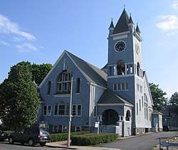 Roslindale Congregational Church | |
| Nickname(s): Rozzi | |
| Country | United States |
| State | Massachusetts |
| County | Suffolk |
| Neighborhood of | Boston |
| Annexed by Boston | 1873 |
| Time zone | UTC-5 (Eastern) |
| Zip Code | 02131 |
| Area code(s) | 617 / 857 |
Six miles south-southwest of downtown Boston, Roslindale was originally part of the town of Roxbury. In 1851, current day Jamaica Plain, Roslindale and West Roxbury seceded from Roxbury. The area voted in 1873 to be annexed to the City of Boston.[1]
In the 1860s, the area was called South Street Crossing, due to the railroad's intersection with South Street. However, when the community applied for a post office district of its own, the name "South Street Crossing" proved to be unacceptable to the government. The name Roslindale was suggested by John Pierce, a well-traveled member of the community, who told the assembled citizens that the area reminded him of the historic town of Roslin, Scotland, outside Edinburgh. Pierce thought the area was like a dale because of the hills surrounding it. Thus the combination of "Roslin" and "dale" was submitted to the United States Postal Service and the name Roslindale was formally established.[2]
Roslindale grew residentially as a classic streetcar suburb. The railway was built after the American Civil War, and spawned a new round of commercial development. Roslindale saw steady growth in its residential population, beginning in the 1880s, with the introduction of the horse-drawn street railway service between Forest Hills and Dedham.
On March 14, 1887, a Boston & Providence Railroad train consisting of a locomotive and nine passenger cars inbound from Dedham to Boston with over 200 passengers, was passing over a bridge at Bussey Street, in the current Arnold Arboretum, when the bridge collapsed causing the rear five cars to pile up on top of each other, killing twenty-three and injuring over one hundred.[3] This is considered one of the first major rail catastrophes in the country, and contributed to the widespread inspection of train bridges across the U.S.[2]
In the 1920s, Roslindale Village assumed the configuration it has today, with tree-lined Adams Park at its center. Roslindale falls in a crease between several other Boston neighborhoods and the parts of Roslindale adjacent to these surrounding neighborhoods take on the characteristics of those neighborhoods. For example, the western part of Roslindale blends seamlessly with West Roxbury's one and two family residences and tree lined streets; and Roslindale's northern area consists of dense two and three family residences amidst light industrial buildings similar to the adjacent Stony Brook corridor in Jamaica Plain.
Prior to the rise of suburban shopping malls in the 1970s, the Roslindale business district, Roslindale Square, was a major shopping district for the city of Boston, with department stores, showrooms, food markets, and a movie theatre. After suffering years of vacant storefronts and increased vandalism during the 1970s, 1980s & 1990s Roslindale Square enjoys limited success today as a local shopping district.
Roslindale is a diverse neighborhood—according to the 2010 census, the racial makeup of its inhabitants was 49% Non-Hispanic White, 18% Non-Hispanic Black or African-American, 25% Hispanic or Latino and 3% Asian or Pacific Islander.
Notable people
Education
Elementary schools
- Sacred Heart School
- John D Philbrick
- George H Conley
- Charles Sumner
- Mozart
- Phineas Bates
- Dennis C Haley
- Children's Learning Center
- Brooke Charter School
Middle schools
- Sacred Heart School
- Edward Brooke Charter School
- Washington Irving Middle School
High schools
- St. Clare High School [closed - building is now the Edward Brooke Middle School]
See also
- District 5, Boston
References
- Alexander von Hoffman (1996). Local Attachments: The Making of an American Urban Neighborhood, 1850 to 1920 (Creating the North American Landscape). The Johns Hopkins University Press. ISBN 0-8018-5393-1.
- Anthony Mitchell Sammarco (1997). Images of America — Roslindale. Arcadia Publishing. ISBN 0-7524-0424-5.
- "Archive of several contemporary articles about the accident". Jamaica Plain Historical Society. Archived from the original on 2012-06-17.
Further reading
- Sammarco, Anthony Mitchell, Roslindale: Then & Now, Arcadia Publishing, 2003