Cape Lookout (North Carolina)
Cape Lookout is the southern point of the Core Banks, one of the natural barrier islands on the Atlantic coast of North Carolina, USA. It delimits Onslow Bay to the west from Raleigh Bay to the east. Core Banks and Shackleford Banks have been designated as parts of the Cape Lookout National Seashore.[1]
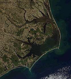
Cape Lookout is part of Carteret County and is located 11 miles southeast of Beaufort, NC. Cape Lookout is one of North Carolina's three major capes; the other two are Cape Hatteras to the north and Cape Fear to the south.
The Cape Lookout Lighthouse is located on the cape, approximately three miles northeast of the point of the cape.[2] The height of the lighthouse is 163 feet.[3]
Climate
According to the Trewartha climate classification system, Cape Lookout, North Carolina has a humid subtropical climate with hot and humid summers, cool winters and year-around precipitation (Cfak). Cfak climates are characterized by all months having an average mean temperature > 32.0 °F (> 0.0 °C), at least eight months with an average mean temperature ≥ 50.0 °F (≥ 10.0 °C), at least one month with an average mean temperature ≥ 71.6 °F (≥ 22.0 °C) and no significant precipitation difference between seasons. During the summer months in Cape Lookout, a cooling afternoon sea breeze is present on most days, but episodes of extreme heat and humidity can occur with heat index values ≥ 100 °F (≥ 38 °C). Cape Lookout is prone to hurricane strikes, particularly during the Atlantic hurricane season which extends from June 1 through November 30, sharply peaking from late August through September. During the winter months, episodes of cold and wind can occur with wind chill values < 10 °F (< -12 °C). The plant hardiness zone in Cape Lookout is 8b with an average annual extreme minimum air temperature of 14.6 °F (-9.7 °C).[4] The average seasonal (Dec-Mar) snowfall total is < 2 inches (< 5 cm), and the average annual peak in nor'easter activity is in February.
| Climate data for Cape Lookout, NC (1981-2010 Averages) | |||||||||||||
|---|---|---|---|---|---|---|---|---|---|---|---|---|---|
| Month | Jan | Feb | Mar | Apr | May | Jun | Jul | Aug | Sep | Oct | Nov | Dec | Year |
| Average high °F (°C) | 52.6 (11.4) |
54.1 (12.3) |
59.0 (15.0) |
65.8 (18.8) |
72.8 (22.7) |
80.0 (26.7) |
83.1 (28.4) |
82.6 (28.1) |
79.3 (26.3) |
71.6 (22.0) |
64.2 (17.9) |
56.0 (13.3) |
68.5 (20.3) |
| Daily mean °F (°C) | 46.4 (8.0) |
48.0 (8.9) |
53.2 (11.8) |
60.6 (15.9) |
68.1 (20.1) |
76.0 (24.4) |
79.5 (26.4) |
78.8 (26.0) |
75.0 (23.9) |
66.1 (18.9) |
57.9 (14.4) |
49.7 (9.8) |
63.3 (17.4) |
| Average low °F (°C) | 40.1 (4.5) |
41.8 (5.4) |
47.3 (8.5) |
55.4 (13.0) |
63.4 (17.4) |
71.9 (22.2) |
75.9 (24.4) |
75.0 (23.9) |
70.8 (21.6) |
60.5 (15.8) |
51.6 (10.9) |
43.4 (6.3) |
58.2 (14.6) |
| Average precipitation inches (mm) | 4.52 (115) |
3.71 (94) |
4.42 (112) |
3.31 (84) |
4.27 (108) |
4.52 (115) |
6.02 (153) |
7.26 (184) |
6.71 (170) |
4.48 (114) |
4.05 (103) |
4.01 (102) |
57.28 (1,455) |
| Average relative humidity (%) | 74.7 | 75.1 | 74.5 | 74.9 | 76.7 | 79.0 | 82.2 | 79.7 | 78.9 | 75.1 | 77.5 | 75.9 | 77.0 |
| Average dew point °F (°C) | 38.8 (3.8) |
40.5 (4.7) |
45.3 (7.4) |
52.6 (11.4) |
60.5 (15.8) |
69.0 (20.6) |
73.6 (23.1) |
72.0 (22.2) |
68.0 (20.0) |
58.0 (14.4) |
50.9 (10.5) |
42.4 (5.8) |
56.0 (13.3) |
| Source: PRISM[5] | |||||||||||||
| Climate data for Cape Hatteras, NC Ocean Water Temperature (72 NE Cape Lookout) | |||||||||||||
|---|---|---|---|---|---|---|---|---|---|---|---|---|---|
| Month | Jan | Feb | Mar | Apr | May | Jun | Jul | Aug | Sep | Oct | Nov | Dec | Year |
| Daily mean °F (°C) | 49 (9) |
46 (8) |
52 (11) |
59 (15) |
68 (20) |
74 (23) |
78 (26) |
80 (27) |
77 (25) |
70 (21) |
58 (14) |
55 (13) |
64 (18) |
| Source: NOAA[6] | |||||||||||||
Ecology
According to the A. W. Kuchler U.S. potential natural vegetation types, Cape Lookout, North Carolina would have a dominant vegetation type of Live oak/Sea Oats Uniola paniculata (90) with a dominant vegetation form of Coastal Prairie (20).[7]
References
- Cape Lookout National Seashore. "Current Documents". Retrieved October 22, 2011.
- Cape Lookout National Seashore. "Maps". Retrieved October 22, 2011.
- "Cape Lookout Lighthouse". outerbankslighthousesociety.org.
- "USDA Interactive Plant Hardiness Map". United States Department of Agriculture. Retrieved August 6, 2019.
- "PRISM Climate Group, Oregon State University". Retrieved August 6, 2019.
- "Water Temperature Table of All Coastal Regions". Retrieved August 6, 2019.
- "U.S. Potential Natural Vegetation, Original Kuchler Types, v2.0 (Spatially Adjusted to Correct Geometric Distortions)". Retrieved August 6, 2019.
| Preceded by Core Banks |
Beaches of The Outer Banks | Succeeded by Shackleford Banks Southeastern North Carolina Beaches |