Southern Shores, North Carolina
Southern Shores is a town in Dare County, North Carolina, United States. It is located on the Outer Banks[4] and the population was 2,714 at the 2010 census.[5]
Southern Shores, North Carolina | |
|---|---|
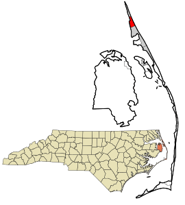 Location in Dare County and the state of North Carolina | |
| Coordinates: 36°7′28″N 75°43′57″W | |
| Country | United States |
| State | North Carolina |
| County | Dare |
| Area | |
| • Total | 4.2 sq mi (10.8 km2) |
| • Land | 3.9 sq mi (10.2 km2) |
| • Water | 0.2 sq mi (0.5 km2) |
| Elevation | 20 ft (6 m) |
| Population (2010) | |
| • Total | 2,714 |
| • Estimate (2018)[1] | 2,915 |
| • Density | 650/sq mi (250/km2) |
| Time zone | UTC-5 (Eastern (EST)) |
| • Summer (DST) | UTC-4 (EDT) |
| ZIP code | 27949 |
| Area code(s) | 252 |
| FIPS code | 37-63130[2] |
| GNIS feature ID | 1001094[3] |
| Website | southernshores-nc |
Geography
Southern Shores is located at 36°7′28″N 75°43′57″W (36.124454, -75.732612).[6]
According to the United States Census Bureau, the town has a total area of 4.2 square miles (10.8 km2), of which 3.9 square miles (10.2 km2) is land and 0.19 square miles (0.5 km2), or 4.92%, is water.[5]
Demographics
| Historical population | |||
|---|---|---|---|
| Census | Pop. | %± | |
| 1980 | 395 | — | |
| 1990 | 617 | 56.2% | |
| 2000 | 2,201 | 256.7% | |
| 2010 | 2,714 | 23.3% | |
| Est. 2018 | 2,915 | [1] | 7.4% |
| sources:[7] | |||
As of the census[2] of 2000, there were 2,201 people, 946 households, and 725 families residing in the town. The population density was 540.4 people per square mile (208.8/km²). There were 1,921 housing units at an average density of 471.7 per square mile (182.2/km²). The racial makeup of the town was 98.23% White, 0.09% African American, 0.23% Native American, 0.23% Asian, 0.09% Pacific Islander, 0.64% from other races, and 0.50% from two or more races. Hispanic or Latino of any race were 1.54% of the population.
There were 946 households out of which 21.8% had children under the age of 18 living with them, 71.6% were married couples living together, 3.7% had a female householder with no husband present, and 23.3% were non-families. 20.2% of all households were made up of individuals and 9.5% had someone living alone who was 65 years of age or older. The average household size was 2.33 and the average family size was 2.64.
In the town, the population was spread out with 18.6% under the age of 18, 2.7% from 18 to 24, 17.4% from 25 to 44, 36.5% from 45 to 64, and 24.9% who were 65 years of age or older. The median age was 51 years. For every 100 females, there were 97.4 males. For every 100 females age 18 and over, there were 93.2 males.
The median income for a household in the town was $61,676, and the median income for a family was $68,250. Males had a median income of $41,563 versus $31,875 for females. The per capita income for the town was $35,933. About 1.6% of families and 3.1% of the population were below the poverty line, including 4.6% of those under age 18 and 0.8% of those age 65 or over.
Climate
According to the Trewartha climate classification system, Southern Shores, North Carolina has a humid subtropical climate with hot and humid summers, cool winters and year-around precipitation (Cfak). Cfak climates are characterized by all months having an average mean temperature > 32.0 °F (> 0.0 °C), at least eight months with an average mean temperature ≥ 50.0 °F (≥ 10.0 °C), at least one month with an average mean temperature ≥ 71.6 °F (≥ 22.0 °C) and no significant precipitation difference between seasons. During the summer months in Southern Shores, a cooling afternoon sea breeze is present on most days, but episodes of extreme heat and humidity can occur with heat index values ≥ 100 °F (≥ 38 °C). Southern Shores is prone to hurricane strikes, particularly during the Atlantic hurricane season which extends from June 1 through November 30, sharply peaking from late August through September. During the winter months, episodes of cold and wind can occur with wind chill values < 10 °F (< -12 °C). The plant hardiness zone in Southern Shores is 8b with an average annual extreme minimum air temperature of 16.3 °F (-8.7 °C).[8] The average seasonal (Dec-Mar) snowfall total is < 2 inches (< 5 cm), and the average annual peak in nor'easter activity is in February.
| Climate data for Southern Shores, NC (1981-2010 Averages) | |||||||||||||
|---|---|---|---|---|---|---|---|---|---|---|---|---|---|
| Month | Jan | Feb | Mar | Apr | May | Jun | Jul | Aug | Sep | Oct | Nov | Dec | Year |
| Average high °F (°C) | 49.1 (9.5) |
51.1 (10.6) |
56.5 (13.6) |
64.6 (18.1) |
72.1 (22.3) |
79.4 (26.3) |
83.4 (28.6) |
81.8 (27.7) |
77.2 (25.1) |
69.4 (20.8) |
61.3 (16.3) |
53.0 (11.7) |
66.6 (19.2) |
| Daily mean °F (°C) | 43.0 (6.1) |
44.8 (7.1) |
49.7 (9.8) |
58.0 (14.4) |
66.0 (18.9) |
74.4 (23.6) |
78.7 (25.9) |
77.9 (25.5) |
73.3 (22.9) |
64.5 (18.1) |
55.8 (13.2) |
46.9 (8.3) |
61.2 (16.2) |
| Average low °F (°C) | 37.0 (2.8) |
38.4 (3.6) |
43.0 (6.1) |
51.3 (10.7) |
59.9 (15.5) |
69.4 (20.8) |
74.1 (23.4) |
73.9 (23.3) |
69.4 (20.8) |
59.6 (15.3) |
50.2 (10.1) |
40.9 (4.9) |
55.7 (13.2) |
| Average precipitation inches (mm) | 4.16 (106) |
3.47 (88) |
3.86 (98) |
3.38 (86) |
3.71 (94) |
4.27 (108) |
4.98 (126) |
5.88 (149) |
5.21 (132) |
3.79 (96) |
3.64 (92) |
3.67 (93) |
50.02 (1,271) |
| Average relative humidity (%) | 70.0 | 69.4 | 67.6 | 68.0 | 70.7 | 75.1 | 76.8 | 75.4 | 73.7 | 71.8 | 72.5 | 71.9 | 71.9 |
| Average dew point °F (°C) | 33.9 (1.1) |
35.4 (1.9) |
39.4 (4.1) |
47.5 (8.6) |
56.2 (13.4) |
66.0 (18.9) |
70.8 (21.6) |
69.5 (20.8) |
64.4 (18.0) |
55.2 (12.9) |
47.1 (8.4) |
38.3 (3.5) |
52.1 (11.2) |
| Source: PRISM[9] | |||||||||||||
| Climate data for Duck, NC Ocean Water Temperature (4 N Southern Shores) | |||||||||||||
|---|---|---|---|---|---|---|---|---|---|---|---|---|---|
| Month | Jan | Feb | Mar | Apr | May | Jun | Jul | Aug | Sep | Oct | Nov | Dec | Year |
| Daily mean °F (°C) | 45 (7) |
44 (7) |
46 (8) |
59 (15) |
67 (19) |
74 (23) |
71 (22) |
74 (23) |
75 (24) |
69 (21) |
59 (15) |
52 (11) |
61 (16) |
| Source: NOAA[10] | |||||||||||||
Ecology
According to the A. W. Kuchler U.S. potential natural vegetation types, Southern Shores, North Carolina would have a dominant vegetation type of Live oak/Sea Oats Uniola paniculata (90) with a dominant vegetation form of Coastal Prairie (20).[11]
References
- "Population and Housing Unit Estimates". Retrieved December 7, 2019.
- "U.S. Census website". United States Census Bureau. Retrieved 2008-01-31.
- "US Board on Geographic Names". United States Geological Survey. 2007-10-25. Retrieved 2008-01-31.
- "Southern Shores". Outer Banks Visitors Bureau. Retrieved April 5, 2013.
- "Geographic Identifiers: 2010 Demographic Profile Data (G001): Southern Shores town, North Carolina". U.S. Census Bureau, American Factfinder. Archived from the original on February 13, 2020. Retrieved November 20, 2015.
- "US Gazetteer files: 2010, 2000, and 1990". United States Census Bureau. 2011-02-12. Retrieved 2011-04-23.
- "Census of Population and Housing". U.S. Census Bureau. Retrieved April 5, 2013.
- "USDA Interactive Plant Hardiness Map". United States Department of Agriculture. Retrieved August 6, 2019.
- "PRISM Climate Group, Oregon State University". Retrieved August 6, 2019.
- "Water Temperature Table of All Coastal Regions". Retrieved August 6, 2019.
- "U.S. Potential Natural Vegetation, Original Kuchler Types, v2.0 (Spatially Adjusted to Correct Geometric Distortions)". Retrieved August 6, 2019.
External links
| Preceded by Duck |
Beaches of The Outer Banks | Succeeded by Kitty Hawk |
Municipalities and communities of Dare County, North Carolina, United States | ||
|---|---|---|
| Towns |  Dare County map | |
| CDPs | ||
| Unincorporated communities | ||
| Ghost town | ||