Lakhimpur district
Lakhimpur (/ˌlækɪmˈpʊər/ LAK-im-POOR) is an administrative district in the state of Assam in India. The district headquarter is located at North Lakhimpur. The district is bounded on the North by Siang and Papumpare District of Arunachal Pradesh and on the East by Dhemaji District and Subansiri River. Majuli District stands on the Southern side and Biswanath District is on the West.
Lakhimpur district | |
|---|---|
District of Assam | |
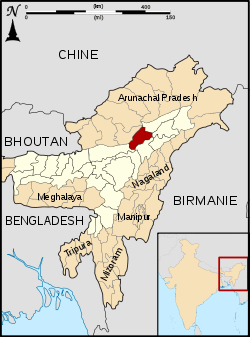 Location of Lakhimpur district in Assam | |
| Country | India |
| State | Assam |
| Headquarters | North Lakhimpur |
| Tehsils | 1. North Lakhimpur, 2. Dhakuakhana, 3. Kadam, 4. Naoboicha, 5. Bihpuria, 6. Narayanpur 7. Subansiri (Ghilamara) |
| Government | |
| • Lok Sabha constituencies | 1. 14-Lakhimpur HPC |
| • Vidhan Sabha constituencies | 1. 109-Bihpuria, 2. 110-Naoboicha, 3. 111-Lakhimpur, 4. 114-Dhakuakhana (ST) |
| Area | |
| • Total | 2,277 km2 (879 sq mi) |
| Population (2011) | |
| • Total | 1,042,137 |
| • Density | 460/km2 (1,200/sq mi) |
| Demographics | |
| • Literacy | 78.39 % |
| • Sex ratio | 965 female per 1000 male |
| Time zone | UTC+05:30 (IST) |
| Major highways | NH-15 |
| Website | www |
History
Lakhimpur figures largely in the annals of Assam as the region where tribes from the east first reached the Brahmaputra. The most prominent of them was the Chutiya rulers who held the areas of the present district for long, until the outbreak of the Ahom-Chutiya conflict in the 16th century and eventually the area came under the rule of the Ahom dynasty.The Ahoms created a new position called Bhatialia Gohain to control the region.[1] The area was later given by Ahoms to the Baro-Bhuyans to rule like feudal lords, as they had helped defeat the Chutiya and Kachari kingdoms. There was a Chutia principality formed by the king Lakshminarayan in the start of the 15th century upon which the district has been named. The copperplate inscription of a land grant given by the Chutia king in the year 1403 A.D. in the west of the Subansiri rive(Swarnadi) as well as the ruins between Dhal and Ghagar rivers(near present-day North Lakhimpur town) shows the evidence of the settlement. The Burmese, who had ruined the native kingdoms, at the end of the 18th century, was in 1826 expelled by the British under the Treaty of Yandaboo. They placed the southern part of the state, together with Sivasagar under the rule of Raja Purandhar Singh; but it was not till 1838 that the whole was taken under direct British Administration.
Lakhimpur district used to have several other districts of Arunachal Pradesh within its fold and was known as the Lakhimpur Frontier Tract. After independence, the district contained the present day Dibrugarh district, Tinsukia district and Dhemaji district. Its headquarter was at Dibrugarh.
In 1976, Dibrugarh district was separated from Lakhimpur.[2] This was repeated on 14 October 1989, with the formation of Dhemaji district.[2]
Etymology
The name Lakhimpur was derived from the name "Lakshmipur" which was given by the Chutiya king named Lakshminaryan who ruled during the 15th century. Later, it was changed by the Baro-Bhuyans to Lakhimpur, when they were made feudal lords of the region by the Ahoms after defeating the Chutiya kings and was kept in memory of the land (in present-day Darrang district), which they lost to the Koch kingdom.
Geography
Lakhimpur district occupies an area of 2,277 square kilometres (879 sq mi),[3] comparatively equivalent to Indonesia's Yapen Island.[4]
Located in the North-East corner of the Indian State of Assam, the district of Lakhimpur lies on the North bank of the river Brahmaputra. It is bounded on the North by Lower Subansiri and Papumpare Districts of the state of Arunachal Pradesh and on the East by Dhemaji District. Majuli, the largest river-island district is on the South and Biswanath District is on the West. The Brahmaputra is navigable for steamers in all seasons as far as Dibrugarh, in the rainy season as far as Sadiya; its navigable tributaries within the district are the Subansiri, Ranganadi, and Dikrong. The exact location of the district is 26.48’ and 27.53’ Northern latitude and 93.42’ and 94.20' East longitude (approx.).
The district has three sub divisions -- Dhakuakhana, Narayanpur-Bihpuria and North Lakhimpur (sadar). Lakhimpur district has eight Police stations. viz. North Lakhimpur, Boginadi, Panigaon, Dhakuakhana , Ghilamara, Narayanpur, Laluk and Bihpuria.
Forests are mainly tropical rain forest. Important reserved forests includes Ranga Reserve, Kakoi Reserve, Dulung Reserve and Pabho Reserve. Some varieties are Hollokh (Terminalia myriocarpa), Ajhar (Lagerstroemia speciosa), Simolu (Bombax ceiba or Salmalia malabarica), Sum (Machilus), Gomari (Gmelina arborea), Sisu (Dalbergia sissoo), Silikha (Terminalia chebula), Neem (Azadirachta indica), Nahar (Mesua ferrea) etc. Wild elephants, buffaloes, tigers, deer etc. are there in the forests. Varieties of bird species are observed in swampy areas.
The great Subansiri River has legends of once famous gold washing. But as of now, there is no any major exploration of minerals in the district, except some minor exploration for petroleum by ONGC (Oil and Natural Gas Corporation) near Dhakuakhana.
Economy
The economy of Lakhimpur is mainly based on agriculture. Major crops are rice, tea, mustard, sugarcane, etc. A small number of SSc and MSc industries[5][6] are located in the district.
Divisions
There are four Assam Legislative Assembly constituencies in this district: Bihpuria, Naoboicha, Lakhimpur, and Dhakuakhana.[7] Dhakuakhana is designated for scheduled tribes.[7] Bihpuria is in the Tezpur Lok Sabha constituency, whilst the other three are in the Lakhimpur Lok Sabha constituency.[8]
Demographics
| Historical population | ||
|---|---|---|
| Year | Pop. | ±% p.a. |
| 1901 | 73,409 | — |
| 1911 | 92,708 | +2.36% |
| 1921 | 124,296 | +2.98% |
| 1931 | 154,021 | +2.17% |
| 1941 | 188,977 | +2.07% |
| 1951 | 222,883 | +1.66% |
| 1961 | 335,346 | +4.17% |
| 1971 | 480,838 | +3.67% |
| 1991 | 751,517 | +2.26% |
| 2001 | 889,010 | +1.69% |
| 2011 | 1,042,137 | +1.60% |
| source:[9] | ||
Population
According to the 2011 census Lakhimpur district has a population of 1,042,137,[10] roughly equal to the nation of Cyprus[11] or the US state of Rhode Island.[12] This gives it a ranking of 435th in India (out of a total of 640).[10] The district has a population density of 457 inhabitants per square kilometre (1,180/sq mi) .[10] Its population growth rate over the decade 2001-2011 was 17.06%.[10] Lakhimpur has a sex ratio of 965 females for every 1000 males,[10] and a literacy rate of 78.39%.[10]
Language
The district is multi-cultural and multi-ethnic in nature. Indigenous Assamese ethnic groups like Chutia, Ahom, Koch, Mising, Deori, Tiwa (Lalung), Bodos, Thengal Kachari, Sonowal Kachari, Khamti dominates the district. Tea tribes community also called Adivasi forms nearly one-tenth of the district's population and mainly resides in the western and northern part of the district along the foothills. Other communities include Bengali Hindus, Nepali speakers,
Flora and fauna
In the year 1996 Lakhimpur district became home to the Bardoibum-Beelmukh Wildlife Sanctuary, which has an area of 11 km2 (4.2 sq mi).[13] It shares the park with Dhemaji district.
References
- Barua,G.C.Ahom Buranji, p.59, 61
- Law, Gwillim (2011-09-25). "Districts of India". Statoids. Retrieved 2011-10-11.
- Srivastava, Dayawanti et al. (ed.) (2010). "States and Union Territories: Assam: Government". India 2010: A Reference Annual (54th ed.). New Delhi, India: Additional Director General, Publications Division, Ministry of Information and Broadcasting (India), Government of India. p. 1116. ISBN 978-81-230-1617-7.CS1 maint: extra text: authors list (link)
- "Island Directory Tables: Islands by Land Area". United Nations Environment Program. 1998-02-18. Retrieved 2011-10-11.
Yapen 2,278km2
- "Small Scale Industries ( SSI ) – Characteristics, Objectives, Registration of SSI". cleartax. 9 March 2020. Retrieved 9 April 2020.
- "What Is a Medium-Scale Industry?". Chron. 19 December 2018. Retrieved 9 April 2020.
- "List of Assembly Constituencies showing their Revenue & Election District wise break - up" (PDF). Chief Electoral Officer, Assam website. Archived from the original (PDF) on 22 March 2012. Retrieved 26 September 2011.
- "List of Assembly Constituencies showing their Parliamentary Constituencies wise break - up" (PDF). Chief Electoral Officer, Assam website. Archived from the original (PDF) on 22 March 2012. Retrieved 26 September 2011.
- Decadal Variation In Population Since 1901
- "District Census 2011". Census2011.co.in. 2011. Retrieved 2011-09-30.
- US Directorate of Intelligence. "Country Comparison:Population". Retrieved 2011-10-01.
Cyprus 1,120,489 July 2011 est.
- "2010 Resident Population Data". U. S. Census Bureau. Archived from the original on 2013-10-19. Retrieved 2011-09-30.
Rhode Island 1,052,567
- Indian Ministry of Forests and Environment. "Protected areas: Assam". Archived from the original on August 23, 2011. Retrieved September 25, 2011.

- Official site
External links
| Wikimedia Commons has media related to Lakhimpur district. |
Places adjacent to Lakhimpur district | |
|---|---|