North Lakhimpur
North Lakhimpur (/ˌlækɪmˈpʊər/ LAK-im-POOR) is a town and a municipal board in Lakhimpur district in the Indian state of Assam, about 394 kilometres (245 mi) northeast of Guwahati. It is the district headquarters of Lakhimpur district.
North Lakhimpur | |
|---|---|
Town | |
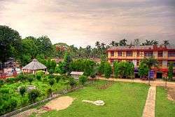 North Lakhimpur College, North Lakhimpur | |
 North Lakhimpur Location in Assam, India  North Lakhimpur North Lakhimpur (India) | |
| Coordinates: 27°14′29″N 94°6′20″E | |
| Country | |
| State | Assam |
| District | Lakhimpur |
| Government | |
| • Body | North Lakhimpur Municipality Board |
| Area | |
| • Total | 13.74 km2 (5.31 sq mi) |
| Elevation | 101 m (331 ft) |
| Population (2011)[1] | |
| • Total | 59,814 |
| • Density | 4,400/km2 (11,000/sq mi) |
| Time zone | UTC+5:30 (IST) |
| PIN | 787001[2] |
| Telephone code | 91-3752[3] |
| ISO 3166 code | IN-AS |
| Vehicle registration | AS-07 |
North Lakhimpur is also the name of the subdivision of Lakhimpur district where North Lakhimpur town is located.
Geographical location
It is situated at 27° 13' 60 N and 94° 7' 0 E.[4] Significant parts of Lakhimpur include Phulbari, Laluk, Dhakuakhana, Narayanpur, Nowboicha, Town Bantow, Chetia para, Khelmati, NT Road, DK Road, KB Road, CD Road, Nakari, Bormuria, Joyhing and Moidomia.
Demographics
As of the 2001 India census,[5] North Lakhimpur had a population of 54,262. Based on population, it is classified as a class-II city (between 50,000 and 99,999 inhabitants). According to the 2011 census, it has a population of 105,376.[6]
Males constituted 53% of the population and females 47%. North Lakhimpur has an average literacy rate of 89%, higher than the national average of 65%: male literacy is 90%, and female literacy is 87%. In North Lakhimpur, 13% of the population is under 6 years of age.
Literature and Social Activist
- Labanya Dutta Goswami, (1952-2009)
- Padmanath Gohain Baruah
Transportation
North Lakhimpur is considered to be the 'Gateway to Arunachal'. It is well connected by air, road and rail.
Air
Lilabari Airport (IXI) is located 5 kilometres (3.1 mi) from the city. It connects Kolkata and Guwahati by Alliance Air service on four days a week: Sunday, Monday, Wednesday, and Friday.
Rail
The North Lakhimpur railway station is located at Nakari. It lies on the Rangia-Murkongselek section of Rangiya railway division. Intercity Express (Murkongselek-Kamakhya) to and fro Guwahati is operating between North Lakhimpur and Guwahati(Kamakhya Stn.) via Rangia, Rangapara, Biswanath Chariali etc. Another Intercity Express(Naharlagun-Guwahati) to and fro Guwahati is operating between Harmuti and Guwahati via Rangia, Rangapara, Biswanath Chariali etc. The Harmuti railway station(jn) is situated in Harmuti, approximately 30 km. from the District HQ.
Road
North Lakhimpur is well connected by road. National Highway 52 passes through the city. Both AC and non-AC buses are available from Assam State Transport Corporation, and private bus stands connect to Guwahati and the other long distance routes.
Climate
| Climate data for North Lakhimpur (1981–2010, extremes 1954–present) | |||||||||||||
|---|---|---|---|---|---|---|---|---|---|---|---|---|---|
| Month | Jan | Feb | Mar | Apr | May | Jun | Jul | Aug | Sep | Oct | Nov | Dec | Year |
| Record high °C (°F) | 29.8 (85.6) |
33.7 (92.7) |
35.4 (95.7) |
36.2 (97.2) |
37.8 (100.0) |
37.6 (99.7) |
38.5 (101.3) |
39.0 (102.2) |
38.0 (100.4) |
37.7 (99.9) |
33.8 (92.8) |
30.8 (87.4) |
39.0 (102.2) |
| Average high °C (°F) | 23.7 (74.7) |
24.6 (76.3) |
26.7 (80.1) |
27.9 (82.2) |
30.3 (86.5) |
31.3 (88.3) |
31.4 (88.5) |
32.1 (89.8) |
31.3 (88.3) |
30.5 (86.9) |
28.4 (83.1) |
25.5 (77.9) |
28.6 (83.5) |
| Average low °C (°F) | 9.3 (48.7) |
12.3 (54.1) |
15.9 (60.6) |
19.0 (66.2) |
22.0 (71.6) |
24.1 (75.4) |
24.7 (76.5) |
24.9 (76.8) |
23.9 (75.0) |
20.8 (69.4) |
14.9 (58.8) |
10.2 (50.4) |
18.5 (65.3) |
| Record low °C (°F) | 2.7 (36.9) |
4.3 (39.7) |
8.1 (46.6) |
11.1 (52.0) |
15.1 (59.2) |
19.5 (67.1) |
19.5 (67.1) |
20.8 (69.4) |
19.2 (66.6) |
10.6 (51.1) |
6.3 (43.3) |
3.1 (37.6) |
2.7 (36.9) |
| Average rainfall mm (inches) | 32.9 (1.30) |
61.6 (2.43) |
99.3 (3.91) |
201.9 (7.95) |
374.3 (14.74) |
633.2 (24.93) |
651.9 (25.67) |
561.7 (22.11) |
439.7 (17.31) |
162.7 (6.41) |
25.9 (1.02) |
25.3 (1.00) |
3,270.2 (128.75) |
| Average rainy days | 3.0 | 5.5 | 7.8 | 13.0 | 15.1 | 20.1 | 22.8 | 19.2 | 15.3 | 7.5 | 2.1 | 2.0 | 133.3 |
| Average relative humidity (%) (at 17:30 IST) | 76 | 72 | 70 | 75 | 75 | 81 | 82 | 82 | 85 | 83 | 79 | 78 | 78 |
| Source: India Meteorological Department[7][8][9] | |||||||||||||
Media
Lakhimpur has an All India Radio relay station known as Akashvani Lakhimpur. It broadcasts on FM frequencies.
Print media
Assamese language newspapers published from North Lakhimpur include the Asomiya Pratidin and Amar Asom.
Education
Colleges
- Lakhimpur College of Veterinary Science
- North Lakhimpur College
- Lakhimpur Girls' College
Notable people
- Uddhab Bharali, innovator
- Raaj J Konwar, Bollywood singer
References
- "Census of India Search details". censusindia.gov.in. Retrieved 10 May 2015.
- India Post. "Pincode search - North Lakhimpur". Retrieved 28 July 2008.
- Bharat Sanchar Nigam Ltd. "STD Codes for cities in Assam". Archived from the original on 26 May 2011. Retrieved 28 July 2008.
- Falling Rain Genomics, Inc. "North Lakhimpur, India Page". Retrieved 11 July 2008.
- "Census of India 2001: Data from the 2001 Census, including cities, villages and towns (Provisional)". Census Commission of India. Archived from the original on 16 June 2004. Retrieved 1 November 2008.
- Census of India. "Alphabetical list of towns and their population - Assam" (PDF). Retrieved 21 May 2008.
- "Station: North Lakhimpur Climatological Table 1981–2010" (PDF). Climatological Normals 1981–2010. India Meteorological Department. January 2015. pp. 565–566. Archived from the original (PDF) on 5 February 2020. Retrieved 6 February 2020.
- "Extremes of Temperature & Rainfall for Indian Stations (Up to 2012)" (PDF). India Meteorological Department. December 2016. p. M28. Archived from the original (PDF) on 5 February 2020. Retrieved 6 February 2020.
- "North Lakhimpur Climatological Table 1971–2000". India Meteorological Department. Retrieved 6 February 2020.