Tezpur
Tezpur (/tɛzˈpʊər/) is a town and urban agglomeration in Sonitpur district, Assam state, India. Tezpur is on the banks of the river Brahmaputra, 175 kilometres (109 mi) northeast of Guwahati, and is the largest of the north bank towns with a population exceeding 100,000 as per Metropolitan Census 2011.[2]
Tezpur | |
|---|---|
Town | |
 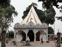 Agnigarh Hill (top) Mahabhairav Temple (botom) | |
| Nickname(s): City of Eternal Romance | |
 Tezpur Location in Assam, India  Tezpur Tezpur (India) | |
| Coordinates: 26.63°N 92.8°E | |
| Country | |
| State | Assam |
| District | Sonitpur |
| Government | |
| • Type | Municipality |
| • Body | Tezpur Municipality Board |
| Area | |
| • Total | 40 km2 (20 sq mi) |
| Elevation | 48 m (157 ft) |
| Population (2011)[1] | |
| • Total | 1,02,505 |
| • Rank | 8th |
| • Density | 2,600/km2 (6,600/sq mi) |
| Languages | |
| • Official | Assamese |
| Time zone | UTC+5:30 (IST) |
| ISO 3166 code | IN-AS |
| Vehicle registration | AS-12 |
| Website | sonitpur |
Tourism
Tezpur have several places to visit:
- Agnigarh: This hillock on bank of river Brahmaputra is the site of legendary romance of princess Usha (the only daughter of king Bana) and Anirudha, grand son of lord Krishna. Usha was kept on this hillock which was surrounded by fire, hence the name of Agnigarh.[3]
- Mahabhairav Temple: The ancient temple of Mahabhairab stands to the north of Tezpur town. This temple is believed to have been established by king Bana with a Siva lingam. Formerly, this temple was built of stone but the present one is built of concrete. During the later years, the Ahom kings donated devottar land for the Temple and Pujaris and Paiks were appointed to look after the temple.[4]
- Chitralekha Udyan (Cole Park): It is one of the most beautiful places in Tezpur. Established by a British Deputy Commissioner, Mr. Cole in 1906, the park has two massive ornamented stone pillars, and other sculptural remnants . It was renovated and revitalized in 1996 under the stewardship of the then Deputy Commissioner, Mr. M.G.V.K.Bhanu, IAS. It has water sports facility, walk ways, restaurant and open air stage.[5]
- Padum Pukhuri: This is a beautiful lake with an island. The island has been developed into a beautiful park with a musical fountain. There is an iron bridge to take you to the island. On the lake one can boat.[6]
- Trimurty Udyan: This is a park along Borpukhuri. This has been named after the three jewels of Assamese culture: Rupkowar Jyoti Prasad Agarwalla, Kalaguru Bishnu Prasad Rabha and Natasurjya Phani Sarmah.[7]
- Rudrapada Temple: To the east of Tezpur town, on the bank of river Brahmaputra the Rudrapada temple is situated. It is believed that Rudra ( Lord Shiva ) had left the print of his left foot (pada) on a stone found in the temple. It is believed that Mahadeva showed his real self to king Bana here. Rudrapada temple was later built by Siva Singha in the year 1730 A.D. The main temple was destroyed, due to erosion of river Brahmaputra.[8]
- Bhomoraguri: It is a mammoth stone inscription made by the Ahom General Kalia Bhomora Borphukan, who planned to construct a bridge over Brahmaputra. Almost two centuries later, a bridge at the same site now stands completed. The 3.015 km bridge, named after the great Ahom general, connects Silghat of Nagaon district with Tezpur.[9]
- Bamuni Hills: The ruins of Bamuni Hills are famous for their exemplary artistic finesse. The sculptural remains date back to the ninth and tenth century A.D.[10]
- The Hazara Pukhuri: It is a large tank in name of Harjar Varman in Tezpur. It was excavated in the early part of the 9th century.[11]
Climate
The average temperature in summer is around 36 °C (97 °F) while the average winter temperature is around 13 °C (55 °F).[12]
| Climate data for Tezpur (1981–2010, extremes 1901–present) | |||||||||||||
|---|---|---|---|---|---|---|---|---|---|---|---|---|---|
| Month | Jan | Feb | Mar | Apr | May | Jun | Jul | Aug | Sep | Oct | Nov | Dec | Year |
| Record high °C (°F) | 28.8 (83.8) |
33.2 (91.8) |
38.2 (100.8) |
38.7 (101.7) |
39.1 (102.4) |
39.4 (102.9) |
39.5 (103.1) |
39.5 (103.1) |
38.9 (102.0) |
37.9 (100.2) |
34.3 (93.7) |
33.9 (93.0) |
39.5 (103.1) |
| Average high °C (°F) | 23.5 (74.3) |
25.8 (78.4) |
29.0 (84.2) |
29.4 (84.9) |
30.8 (87.4) |
31.7 (89.1) |
31.5 (88.7) |
32.1 (89.8) |
31.4 (88.5) |
30.5 (86.9) |
28.0 (82.4) |
24.6 (76.3) |
29.0 (84.2) |
| Average low °C (°F) | 11.4 (52.5) |
13.8 (56.8) |
17.1 (62.8) |
19.8 (67.6) |
22.4 (72.3) |
24.6 (76.3) |
25.2 (77.4) |
25.4 (77.7) |
24.5 (76.1) |
21.7 (71.1) |
16.6 (61.9) |
12.6 (54.7) |
19.6 (67.3) |
| Record low °C (°F) | 5.6 (42.1) |
6.1 (43.0) |
10.0 (50.0) |
12.2 (54.0) |
14.4 (57.9) |
17.6 (63.7) |
21.2 (70.2) |
20.3 (68.5) |
19.9 (67.8) |
14.5 (58.1) |
10.6 (51.1) |
6.1 (43.0) |
5.6 (42.1) |
| Average rainfall mm (inches) | 11.4 (0.45) |
24.9 (0.98) |
50.2 (1.98) |
178.7 (7.04) |
259.4 (10.21) |
312.9 (12.32) |
323.9 (12.75) |
293.8 (11.57) |
236.3 (9.30) |
117.1 (4.61) |
19.0 (0.75) |
9.7 (0.38) |
1,837.4 (72.34) |
| Average rainy days | 1.3 | 2.3 | 4.8 | 12.3 | 13.6 | 15.3 | 16.1 | 13.7 | 12.8 | 5.6 | 1.4 | 1.0 | 100.3 |
| Average relative humidity (%) (at 17:30 IST) | 69 | 62 | 57 | 69 | 73 | 79 | 81 | 81 | 83 | 81 | 77 | 74 | 74 |
| Source: India Meteorological Department[13][14][15] | |||||||||||||
Government sector
Tezpur is part of Tezpur (Lok Sabha constituency).[16]
Notable people
See also
- Jamugurihat
- Northeast India
- North Eastern Council
- Ministry for Development of North Eastern Region
References
- http://www.censusindia.gov.in/pca/SearchDetails.aspx?Id=306544
- "Tezpur Metropolitan Urban Region Population 2011 Census". www.census2011.co.in. Retrieved 8 October 2018.
- "Agnigarh | Sonitpur District | Government Of Assam, India". sonitpur.gov.in. Retrieved 8 June 2020.
- "Mahabhairab Temple | Sonitpur District | Government Of Assam, India". sonitpur.gov.in. Retrieved 8 June 2020.
- "Chitralekha Udyan (Cole Park) | Sonitpur District | Government Of Assam, India". sonitpur.gov.in. Retrieved 8 June 2020.
- "Padum Pukhuri | Sonitpur District | Government Of Assam, India". sonitpur.gov.in. Retrieved 8 June 2020.
- "Trimurty Udyan | Sonitpur District | Government Of Assam, India". sonitpur.gov.in. Retrieved 8 June 2020.
- "Rudrapada Temple | Sonitpur District | Government Of Assam, India". sonitpur.gov.in. Retrieved 8 June 2020.
- "Bhomoraguri | Sonitpur District | Government Of Assam, India". sonitpur.gov.in. Retrieved 8 June 2020.
- "Bamuni Hills | Sonitpur District | Government Of Assam, India". sonitpur.gov.in. Retrieved 8 June 2020.
- "The Hazara Pukhuri | Sonitpur District | Government Of Assam, India". sonitpur.gov.in. Retrieved 8 June 2020.
- "Tezpur, India Weather Averages - Monthly Average High and Low Temperature - Average Precipitation and Rainfall days - World Weather Online". Retrieved 2 February 2015.
- "Station: Tezpur Climatological Table 1981–2010" (PDF). Climatological Normals 1981–2010. India Meteorological Department. January 2015. pp. 735–736. Archived from the original (PDF) on 5 February 2020. Retrieved 6 February 2020.
- "Extremes of Temperature & Rainfall for Indian Stations (Up to 2012)" (PDF). India Meteorological Department. December 2016. p. M31. Archived from the original (PDF) on 5 February 2020. Retrieved 6 February 2020.
- "Tezpur Climatological Table 1971–2000". India Meteorological Department. Retrieved 6 February 2020.
- "List of Parliamentary & Assembly Constituencies" (PDF). Assam. Election Commission of India. Archived from the original (PDF) on 4 May 2006. Retrieved 6 October 2008.
External links
| Wikimedia Commons has media related to Tezpur. |

- Sonitpur District
This article is issued from Wikipedia. The text is licensed under Creative Commons - Attribution - Sharealike. Additional terms may apply for the media files.