Jorhat district
Jorhat (pron: ˈʤɔ:(r)ˌhɑ:t) is an administrative district of the Indian state of Assam situated in the central part of the Brahmaputra Valley. The district is bounded by Majuli on north, Nagaland state on the south, Charaideo on the east and Golaghat on the west. On the north of the district, the river Brahmaputra forms the largest riverine island of the world. The administrative seat is at Jorhat town.
Jorhat district যোৰহাট জিলা | |
|---|---|
District of Assam | |
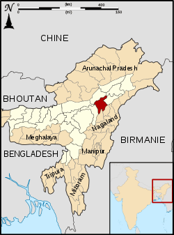 Location of Jorhat district in Assam | |
| Country | India |
| State | Assam |
| Division | Upper Assam |
| Headquarters | Jorhat |
| Tehsils | 1. Jorhat East, 2. Jorhat West, 3. Titabor, 4. Teok, 5. Mariani, |
| Government | |
| • Lok Sabha constituency | Jorhat |
| • Vidhan Sabha constituencies | 1. Jorhat, 2. Titabor, 3. Mariani, 4. Teok, 5. Dergaon |
| Area | |
| • Total | 2,852 km2 (1,101 sq mi) |
| Population (2011) | |
| • Total | 1,092,256 |
| • Density | 380/km2 (990/sq mi) |
| Demographics | |
| • Literacy | 83.42 % |
| • Sex ratio | 956 females per 1000 males |
| Time zone | UTC+05:30 (IST) |
| Major highways | NH-37 |
| Website | www |
Earlier Jorhat was a sub-division of undivided Sibsagar district. In 1983 Jorhat was carved out of Sibsagar District and was made a separate district.
Etymology
"Jorhat" (যোৰহাট) or "Jorehaut" means two "hats" (Bazar) or "mandis"- “Macharhat" (মাছৰহাট) and “Chowkihat" (চকীহাট) which existed on the two different banks of the river Bhugdoi during the 18th century.
History
The northern-most area of the present district was a part of the Chutiya Kingdom before the Ahom-Chutiya war in the 16th century. In 1794 the Ahom king Gaurinath Singha shifted the capital from Sibsagar (erstwhile ”Rangpur”) to Jorhat. This town was a flourishing and commercial metropolis but completely destroyed after a series of the Burmese invasions since 1817 till the arrival of the British force in 1824 under the Stewardship of David Scott and Captain Richard.
The British rule, though, was not free from rebellions and revolutions, contributed to reemergence of this historical town. From the very first decade of the British rule, the great revolutionists who emerged were Gomdhar Konwar, Jeuram and Piyali, British system of administration, came into vogue in 1839 with an established Police Thana. During the great Sepoy Mutiny, the anti-British plot hatched by Maniram Dewan and Piyali Barua, was sabotaged. These leaders were hanged in public at this very place in 1858.[1]
In 1885, a narrow-gauge train service (Jorehaut Provincial Railway) came into operation and ultimately became instrumental in the rapid growth of the tea industry.
Though the civil sub-division under Sibsagar district at Jorhat was formed in 1869, this place was declared as administration headquarters of the undivided Sibsagar district in 1911, which comprised the present Sibsagar, Jorhat and Golaghat and parts of Karbi-Anglong district with Major A. Playfair as the first deputy commissioner.
The modern-day district of Jorhat was created in 1983 when it was split from Sibsagar district.[2]
Geography
On the north of the district, the river Brahmaputra forms the largest riverine island of the world, Majuli, spreading over 924.6 km². with a population of about 1.50 lakh being threatened by the constant erosion by this mighty, unstable river. Majuli had been the principal place of pilgrimage of Vaishnavites since the ages of the Ahom rules. There are several Satras resembling medieval monasteries headed by Satradhikars preaching and teaching the Vaishnavism which was initiated by Sankardeva (1449–1568). Each Satra has unknown wealth of Vaishnav scriptures and extensive revenue free lands being cultivated by the “Bhakats” of the Satras.
Jorhat district occupies an area of 2,851 square kilometres (1,101 sq mi),[3] comparatively equivalent to Russia's Zemlya Georga.[4] Floods frequent the island every year without exception. The mean annual rainfall of the district is 2029 mm.
District administration
The District Administration is headed by Deputy Commissioner Roshani Aparanji Korati, IAS who is an officer belonging to 2011 Batch of IAS (Assam-Meghalaya Cadre).[5] Nimbalkar Vaibhav Chandrakant is the Superintendent of Police of Jorhat district and belongs to the IPS batch of 2009 (Assam-Meghalaya cadre).[6]
The only outlying civil subdivision is Titabor . Titabor subdivisional administration is headed by SDO (Civil) Ayush Garg, IAS.
Divisions
There are five Assam Legislative Assembly constituencies in this district: Jorhat, Teok, Mariani, Titabor and Dergaon.[7] Dergaon is designated for scheduled castes.[7] Dergaon is in the Kaliabor Lok Sabha constituency. The other four are in the Jorhat Lok Sabha constituency.[8]
Economy
Agriculture
There are about 135 tea gardens, including out gardens, and the predominant field crop is rice, with per capita food grain production of 205 kg per annum.
Manufacturing industry
The district has a number of small-scale and cottage industries in the field of cane work and bamboo work, silver jewelry, furniture making, brass smithing, umbrella making, soap manufacturing, packaged food manufacturing etc.
Tourism
Jorhat is the central location for reaching out to many interesting places of international importance: Majuli, Kaziranga National Park, Dhekiakhowa Bornamghar, Lachit Borphukan's Maidam, Raja Maidam, Jorhat Science Centre & Planetarium, Jorhat Gymkhana Club, Chandrakanta Handique Bhavan, Ayur Sanjeeva, Jorhat District Museum, Thengal Bhawan, Gibbon Wildlife Sanctuary, Kaziranga Golf Resort, Sukapha Samannay Kshetra, Molai forest, Shanti Ashram, Jagannath Temple, public parks, tea gardens and Siukapha Park, Gabhoru Parbat and many more.
Demographics
Population
According to the 2011 census Jorhat district has a population of 1,092,256,[9] roughly equal to the nation of Cyprus[10] or the US state of Rhode Island.[11] This gives it a ranking of 419th in India (out of a total of 640).[9] The district has a population density of 383 inhabitants per square kilometre (990/sq mi) .[9] Its population growth rate over the decade 2001-2011 was 9.21%.[9] Jorhat has a sex ratio of 956 females for every 1000 males,[9] and a literacy rate of 83.42%.[9]
The district has SC and ST population of 7.61% and 12.09% respectively of the total population. However, the Majuli Sub-Division has a tribal population of 70% who are primarily “Misings”.
Main communities in the district are Tea tribes (Adivasi), Ahom, Chutia, Sonowal Kacharis, Thengal Kachari.
Languages
The primary language of Jorhat is Assamese. Other languages spoken include Mishing, Deori, Aiton, which with approximately 1500 speakers is closely related to Shan and written in the Burmese script.[12]
Culture
The cultural environment which prevails in Jorhat is the result of people to preserve its culture.
Notable personalities
Jorhat has produced many creative writers, historians, journalists.
- Birendra Kumar Bhattacharya, the first Assamese to win India's highest literature award, the Jnanpith Award[13]
- Jadav Payeng(The Forest man of India)
- Krishna Kanta Handique, ideologist and educationist, former vice chancellor of Gauhati University
- Hiren Bhattacharyya, Assamese poet
- Zubeen Garg, musician
- Sonaram Chutia, Vaishnavite Scholar
Flora and fauna
In 1997 Jorhat district became home to the Gibbon Wildlife Sanctuary, which has an area of 21 km2 (8.1 sq mi),[14] is a protected area which is home of hoolock gibbons.
There is another forest called Mulai Kathoni, a man-made forest covering 550 hectares of area on a Brahmaputra river sandbar located near Kokilamukh area.
Education
Jorhat is considered as a good place for modern education.
The Jorhat Government Boys School is the oldest school established in 1883 with special facilities for science teaching. The Jagannath Barooah College is the oldest college in the district (set up in 1930) and said to be first college in Upper Assam. Later, however many degree colleges and schools came up. The people of Jorhat can rightly be proud of being a part of its glorious heritage and culture. Other schools are Army Public School Jorhat, Air Force School, Carmel Convent School, Balya Bhavan, Hemalata Handique Memorial Institute, Don Bosco High School Lichubari, Jyoti Vidyapith Teok, Ben Garden high School, Don Bosco High School, Baghchung, Kendriya Vidyalaya, Jawahar Navodaya Vidyalaya, Jorhat, Jonaki Sangha Vidyalaya, Sankar Dev Vidya Niketan, Bahona Boys High School, Namgorumora Bapu Barhoi High School, Holy Flower high School and many more.
Jorhat is the seat of learning with the first agricultural university in the northeast region — Assam Agricultural University — established in 1969 in addition to the Jorhat Engineering College (1960), North East Institute of Science and Technology (NEIST) (1961), National Institute of Design, Jorhat (2019), Assam Women's University (2013), HRH The Prince of Wales Institute of Engineering and Technology (POWIET) (1926), Tocklai Tea Research Institute (1911), Jorhat Medical College and Hospital (2009), Jorhat Institute of Science & Technology (JIST) and Kaziranga University (2012).
Media
The healthy education and cultural life of Jorhat can be best judged from the fact that the district has as many as five daily newspapers published from two publishing groups.
The Janambhumi Group of Newspapers: The Saptahik Janambhumi, the Dainik Janambhumi, and the Eastern Clarion. The Spatahik Janambhumi celebrated its 50 years of circulation and the Dainik Janambhumi crossed its 25 years of existence.
The G.L. Publication publishes three newspapers from Guwahati and Jorhat simultaneously. They are the North East Times (English), Amar Asom (Assamese), and the Purbanchal Prohori (Hindi).
The other newspapers published from Jorhat are: Dainik Agradoot, Asomiya Khobor and The Telegraph
References
- Guptajit Pathak (2008). Assamese Women in Indian Independence Movement: With a Special Emphasis on Kanaklata Barua. Mittal Publications. p. 75. ISBN 978-81-8324-233-2. Retrieved 21 April 2012.
- Law, Gwillim (2011-09-25). "Districts of India". Statoids. Retrieved 2011-10-11.
- Srivastava, Dayawanti et al. (ed.) (2010). "States and Union Territories: Assam: Government". India 2010: A Reference Annual (54th ed.). New Delhi, India: Additional Director General, Publications Division, Ministry of Information and Broadcasting (India), Government of India. p. 1116. ISBN 978-81-230-1617-7.CS1 maint: extra text: authors list (link)
- "Island Directory Tables: Islands by Land Area". United Nations Environment Program. 1998-02-18. Retrieved 2011-10-11.
Zemlya Georga 2,821km2
- https://www.sentinelassam.com/news/roshni-aparanji-korati-appointed-as-the-new-dc-of-jorhat-district/
- https://police.assam.gov.in/about-us/detail/district-superintendents-of-police
- "List of Assembly Constituencies showing their Revenue & Election District wise break - up" (PDF). Chief Electoral Officer, Assam website. Archived from the original (PDF) on 22 March 2012. Retrieved 26 September 2011.
- "List of Assembly Constituencies showing their Parliamentary Constituencies wise break-up" (PDF). Chief Electoral Officer, Assam website. Archived from the original (PDF) on 22 March 2012. Retrieved 26 September 2011.
- "District Census 2011". Census2011.co.in. 2011. Retrieved 2011-09-30.
- US Directorate of Intelligence. "Country Comparison:Population". Retrieved 2011-10-01.
Cyprus 1,120,489 July 2011 est.
- "2010 Resident Population Data". U. S. Census Bureau. Archived from the original on 2011-01-01. Retrieved 2011-09-30.
Rhode Island 1,052,567
- M. Paul Lewis, ed. (2009). "Aiton: A language of India". Ethnologue: Languages of the World (16th ed.). Dallas, Texas: SIL International. Retrieved 2011-09-28.
- "Bhattacharya, Birendrakumar" in Amaresh Datta, ed., Encyclopaedia of Indian literature vol. 1 (Sahitya Akademi, 1987), ISBN 978-81-260-1803-1, p. 482 (excerpt available at Google Books).
- Indian Ministry of Forests and Environment. "Protected areas: Assam". Archived from the original on August 23, 2011. Retrieved September 25, 2011.
External links
Places adjacent to Jorhat district | ||||||||||
|---|---|---|---|---|---|---|---|---|---|---|
| ||||||||||