West Karbi Anglong district
The West Karbi Anglong district is a new district formed out of the existing Karbi Anglong district of Assam in 2015. Hamren is the headquarter of the newly formed district.[4] The district is part of Karbi Anglong Autonomous Council and administered according to the provisions of Sixth Scheduled of the Indian Constitution.
West Karbi Anglong district Nijang Karbi Anglong | |
|---|---|
District of Assam | |
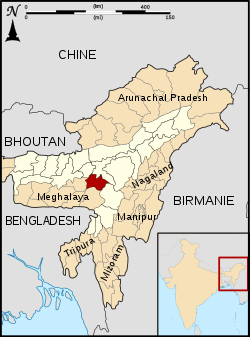 Location of West Karbi Anglong district in Assam | |
| Coordinates (Hamren): 17.35°N 75.16°E - 18.32°N 76.15°E | |
| Country | India |
| State | Assam |
| Division | Central Assam |
| Established | 15 August 2016 |
| Headquarters | Hamren |
| Government | |
| • Lok Sabha constituencies | No.3 MP ST Lok Sabha Constituency |
| • Vidhan Sabha constituencies | No.20 Baithalangso ST LAC |
| Area | |
| • Total | 3,035 km2 (1,172 sq mi) |
| Population (2011)[1] | |
| • Total | 300,320 |
| • Density | 99/km2 (260/sq mi) |
| Languages | |
| • Official | Assamese,[2] English and Hindi[3] |
| • Regional | Karbi |
| Time zone | UTC+05:30 (IST) |
History
The hill tribes of Northeast India were independent of India and Assam prior to the British colonization of this region.[5] After the recommendation of Simon Commission, the hill area (Karbi Anglong district) was given a different status under Section 92 of the Government of India Act 1935: Mikir Hills was placed under the "Partially Excluded Areas". The Govt. of Assam, which means had no jurisdiction over the excluded areas which were administered directly under the special power of the Governor.[5]
During mid-1930: Political leaders Semsonsing Ingti, Seng Bey, Khorsing Terang, etc. emerged from this particular area. In 1937, these leaders, in a memorandum to Assam Governor, Sir Robert Neil Reid, at Mohungodijua, demanded a separate hill district for Mikirs. A regional political forum, called Karbi-A-Durbar, was formed to intensify the movement.
After Independence of India, the hill district was formed by the name of "United Mikir & NC Hills (UMNCH)" on 17 November 1951 under Sixth Schedule of the Indian Constitution. Since then, the district has been constant part of Autonomous State demand movement.[6][7]
In 2016, the district was further divided into two, the western part including Hamren, Baithalangso (Vothatlangso) and Donkamokam and other adjoining areas formed the new district of West Karbi Anglong to develop the mass rural area. Hamren is the headquarters of the newly created district.[8][9]
Geography
Karbi Anglong plateau is an extension of the Indian Plate (The Peninsular Block) in the Assam of India. This area receives maximum rainfall from the Southwest summer Monsoon from June through September.[10] The eastern part of this region is plain and the western part is mostly covered with hills. The important rivers of this district are: The Myntriang River, Karbi Langpi River, Kopili river and Amreng river. Among these rivers, Hydro Electric Project have been set up on the Myntriang and Karbi Langpi rivers.[11][12]
Administration
The district is administrated under Karbi Anglong Autonomous Council. CEM is the Chief executive of the district, supported by fourteen other executive members of the Council.[13] The Principal Secretary (generally an officer selected from IAS cadre) of Karbi Anglong Autonomous Council is the administrative head of the district.[14] The Deputy Commissioner is responsible for the maintenance of law & order, and administration of justice.
Hamren is the district headquarter. The district has only one sub-division, namely Hamren sub-division, and Donkamukam is the only revenue circle of the district.[15]
Demographics
Indigenous communities particularly Karbis, Hill Tiwas, Bodos and Garo form majority of the population. Other non-indigenous communities migrated here include Biharis, Bengalis and Nepalis during the British rule.
Language
Apart from Karbi, other languages such as Garo, Tiwa, English, Hindi, Assamese and Bengali are used for communication.
Population
West Karbi Anglong district has a population of 300,320, out of which 153,763 are males and 146,557 are females. The sex ratio is 973 female per 1000 male. Literacy rate is 85.19%, of which 90.19% are males and 80.19% are females.[1]
Transport
The district headquarter Hamren is connected by road. Karbi Anglong Autonomous Council Transport buses ply at regular interval from district headquarter to important places like Guwahati, Nagaon, Diphu, Lanka, Hojai and Jowai.
Notable town and place of interest
- Donkamokam
- Hamren
- Baithalangso
Notable people
See also
References
- "West Karbi Anglong District | Hill Areas | Government Of Assam, India". had.assam.gov.in. Retrieved 15 September 2019.
- "52nd REPORT OF THE COMMISSIONER FOR LINGUISTIC MINORITIES IN INDIA" (PDF). nclm.nic.in. Ministry of Minority Affairs. Archived from the original (PDF) on 25 May 2017. Retrieved 27 August 2019.
- http://www.neportal.org/northeastfiles/Assam/ActsOrdinances/Assam_Official_Language_Act_1968.asp
- "West Karbi Anglong district inaugurated", The Assam Tribune, 11 February 2016
- Hussain, Monirul (1987). "Tribal Movement for Autonomous State in Assam". Economic and Political Weekly. 22 (32): 1329–1332. ISSN 0012-9976. JSTOR 4377333.
- Menon (15 September 1987). "Karbi tribals demand autonomous state within Assam". India Today. Retrieved 15 September 2019.
- Madhukalya, Amrita (29 July 2018). "Karbi Anglong- Dima Hasao bodies want autonomous state in Assam". DNA India. Retrieved 15 September 2019.
- "Assam get new districts". Retrieved 27 December 2019.
- "West Karbi Anglong district inaugurated" Archived 3 April 2016 at the Wayback Machine, The Assam Tribune, 11 February 2016
- Vasudevan, Hari; et al. (2006). "Structure and Physiography". India:Physical Environment. New Delhi: NCERT. p. 17. ISBN 81-7450-538-5.
- "Running Projects of APGCL | Power | Government Of Assam, India". power.assam.gov.in. Retrieved 15 September 2019.
- "Karbi Langpi Hydroelectric Power Project India - GEO". globalenergyobservatory.org. Retrieved 15 September 2019.
- "KAAC | Legislative & Executive Structure". www.karbianglong.co.in. Retrieved 15 September 2019.
- "KAAC | Administrative Structure". www.karbianglong.co.in. Retrieved 15 September 2019.
- Hasnu, Sunil Kumar. "Official Website of Karbi Anglong Autonomous Council". karbianglong.co.in. Retrieved 15 September 2019.
External links
Places adjacent to West Karbi Anglong district | ||||||||||
|---|---|---|---|---|---|---|---|---|---|---|
| ||||||||||
| Proposed states |
|  |
|---|---|---|
| Proposed union territories |
| |