List of listed buildings in Wigtown, Dumfries and Galloway
This is a list of listed buildings in the civil parish of Wigtown, in Dumfries and Galloway, Scotland.
List
| Name | Location | Date Listed | Grid Ref. [note 1] | Geo-coordinates | Notes | LB Number [note 2] | Image |
|---|---|---|---|---|---|---|---|
| Harbour Road Dunmore With Gates Gatepiers And Boundary Walls | 54°52′00″N 4°26′22″W | Category C(S) | 42390 |  | |||
| 10 And 12 High Street | 54°52′01″N 4°26′42″W | Category C(S) | 42396 | | |||
| 3A And 3B North Main Street | 54°52′08″N 4°26′32″W | Category C(S) | 42401 | | |||
| 17 North Main Street | 54°52′06″N 4°26′37″W | Category B | 42409 | | |||
| 27 North Main Street | 54°52′04″N 4°26′40″W | Category C(S) | 42414 | | |||
| 6 South Main Street | 54°52′06″N 4°26′28″W | Category B | 42422 | | |||
| 18 South Main Street | 54°52′04″N 4°26′33″W | Category B | 42427 | | |||
| 24 South Main Street | 54°52′03″N 4°26′36″W | Category B | 42430 | | |||
| Windy Hill Martyrs Monument And Enclosure | 54°52′08″N 4°26′51″W | Category B | 42442 | 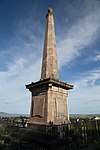 | |||
| 1-4 (Inclusive Nos) Acre Place | 54°51′57″N 4°26′41″W | Category C(S) | 42336 | | |||
| 26 And 28 Agnew Crescent | 54°51′58″N 4°26′39″W | Category C(S) | 42349 | | |||
| 7 Bank Street | 54°52′08″N 4°26′28″W | Category C(S) | 42351 | | |||
| 8 Bank Street | 54°52′08″N 4°26′28″W | Category C(S) | 42358 | | |||
| 24 Bank Street | 54°52′09″N 4°26′25″W | Category C(S) | 42362 | | |||
| 4 And 5 Bladnoch Village | 54°51′29″N 4°27′26″W | Category C(S) | 42366 | | |||
| 27 South Main Street, Post Office | 54°52′03″N 4°26′37″W | Category C(S) | 43768 | | |||
| 19 Bladnoch Village | 54°51′29″N 4°27′32″W | Category C(S) | 42374 | | |||
| 6 And 8 High Street | 54°52′02″N 4°26′41″W | Category C(S) | 42395 | | |||
| 28 High Street | 54°52′01″N 4°26′45″W | Category C(S) | 42397 | | |||
| 32 High Street | 54°52′00″N 4°26′45″W | Category C(S) | 42399 | | |||
| 5 Low Vennel Smithy | 54°52′09″N 4°26′31″W | Category C(S) | 42400 | | |||
| 34 North Main Street The Granite House | 54°52′03″N 4°26′42″W | Category C(S) | 42419 | | |||
| 16 South Main Street Sunningdale | 54°52′04″N 4°26′33″W | Category C(S) | 42426 | | |||
| 22 South Mains Treet | 54°52′04″N 4°26′35″W | Category B | 42428 | | |||
| Woodside With Coach House, Retaining Walls And Railings | 54°51′52″N 4°26′49″W | Category B | 42443 | | |||
| 11 And 13 Agnew Crescent | 54°52′00″N 4°26′41″W | Category C(S) | 42338 | | |||
| 4 Bank Street | 54°52′08″N 4°26′29″W | Category C(S) | 42356 | | |||
| 2 Bladnoch Village | 54°51′29″N 4°27′25″W | Category C(S) | 42365 | | |||
| 11 Bladnoch Village | 54°51′29″N 4°27′28″W | Category C(S) | 42368 | | |||
| 13, 14 And 15 Bladnoch Village | 54°51′29″N 4°27′29″W | Category C(S) | 42370 | | |||
| 26 Bladnoch Village | 54°51′29″N 4°27′36″W | Category C(S) | 42380 | | |||
| Fountainblue Terrace Craigmount Guest House | 54°52′01″N 4°26′50″W | Category C(S) | 42388 | | |||
| 13 North Main Street | 54°52′06″N 4°26′35″W | Category C(S) | 42406 | | |||
| 23 South Main Street Galloway Inn | 54°52′04″N 4°26′35″W | Category B | 42429 | | |||
| 31 And 32 South Main Street | 54°52′02″N 4°26′39″W | Category B | 42435 | | |||
| Bank Street Bank House Garden Wall And Garden Houses | 54°52′08″N 4°26′24″W | Category B | 42363 | | |||
| Bladnoch Bridge | 54°51′28″N 4°27′43″W | Category B | 19151 | | |||
| 24 Bladnoch Village | 54°51′29″N 4°27′34″W | Category C(S) | 42378 | | |||
| 27 Bladnoch Village | 54°51′29″N 4°27′36″W | Category C(S) | 42381 | | |||
| 32 Bladnoch Village | 54°51′30″N 4°27′38″W | Category C(S) | 42383 | | |||
| Harbour Road, Old Prison House With Boundary Walls (Former Jail And Police Station) | 54°51′57″N 4°26′26″W | Category B | 42391 | | |||
| 30 High Street | 54°52′00″N 4°26′45″W | Category C(S) | 42398 | | |||
| 5 And 7 North Main Street | 54°52′08″N 4°26′33″W | Category C(S) | 42403 | | |||
| 29 And 30 North Main Street | 54°52′03″N 4°26′40″W | Category B | 42416 | | |||
| 31 North Main Street | 54°52′03″N 4°26′41″W | Category C(S) | 42417 | | |||
| 29 And 30 South Main Street County Hotel | 54°52′03″N 4°26′39″W | Category C(S) | 42434 | | |||
| The Square Old Market Cross | 54°52′04″N 4°26′37″W | Category B | 42438 | | |||
| The Square Town Hall | 54°52′07″N 4°26′29″W | Category B | 42439 | 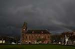 | |||
| 21 Agnew Crescent | 54°51′59″N 4°26′41″W | Category C(S) | 42342 | | |||
| 10 Bank Street | 54°52′09″N 4°26′28″W | Category B | 42359 | | |||
| 20 Bank Street | 54°52′09″N 4°26′26″W | Category C(S) | 42360 | | |||
| 22 Bank Street | 54°52′09″N 4°26′25″W | Category C(S) | 42361 | | |||
| 17 17A And 17B Bladnoch Village | 54°51′29″N 4°27′30″W | Category C(S) | 42372 | | |||
| 9 Harbour Road Former Uf Manse Boundary Wall And Gatepiers | 54°52′02″N 4°26′23″W | Category B | 42392 | | |||
| 18 North Main Street | 54°52′05″N 4°26′37″W | Category C(S) | 42410 | | |||
| 28 North Main Street | 54°52′03″N 4°26′40″W | Category C(S) | 42415 | | |||
| Wigtown Old Parish Church (St Machute`S Church) | 54°52′12″N 4°26′22″W | Category B | 42440 | 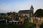 | |||
| 18-20 (Even Nos) Agnew Crescent | 54°51′59″N 4°26′40″W | Category B | 42348 | | |||
| 3 Bank Street | 54°52′07″N 4°26′40″W | Category C(S) | 42350 | | |||
| 11 Bank Street | 54°52′08″N 4°26′27″W | Category C(S) | 42353 | | |||
| 1 Bladnoch Village | 54°51′29″N 4°27′24″W | Category C(S) | 42364 | | |||
| 16 Bladnoch Village | 54°51′29″N 4°27′30″W | Category B | 42371 | | |||
| 18 Bladnoch Village Ashleigh | 54°51′29″N 4°27′31″W | Category B | 42373 | | |||
| 29 Bladnoch Village | 54°51′29″N 4°27′38″W | Category C(S) | 42382 | | |||
| 34 Bladnoch Village And Railings | 54°51′30″N 4°27′40″W | Category C(S) | 42385 | | |||
| 4 High Street | 54°52′02″N 4°26′41″W | Category C(S) | 42394 | | |||
| 11 North Main Street | 54°52′07″N 4°26′34″W | Category B | 42404 | | |||
| 19 North Main Street | 54°52′05″N 4°26′37″W | Category C(S) | 42411 | | |||
| 21 North Main Street, Bank Of Scotland | 54°52′05″N 4°26′38″W | Category C(S) | 42413 | | |||
| 8 South Main Street The Old Custom House And Bank With Railings | 54°52′06″N 4°26′28″W | Category B | 42423 | | |||
| 26 South Main Street | 54°52′03″N 4°26′37″W | Category C(S) | 42432 | | |||
| Wigtown Parish Church (Church Of Scotland) And Churchyard | 54°52′12″N 4°26′21″W | Category B | 42441 | 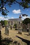 | |||
| 19 Agnew Crescent | 54°51′59″N 4°26′41″W | Category C(S) | 42341 | | |||
| 6 Agnew Crescent | 54°52′01″N 4°26′39″W | Category C(S) | 42343 | | |||
| 10 Agnew Crescent | 54°52′00″N 4°26′39″W | Category C(S) | 42345 | | |||
| 9 Bank Street | 54°52′08″N 4°26′27″W | Category C(S) | 42352 | | |||
| 2 Bank Street | 54°52′08″N 4°26′30″W | Category C(S) | 42355 | | |||
| 7 And 8 Bladnoch | 54°51′29″N 4°27′27″W | Category C(S) | 42367 | | |||
| Newmilns Mill | 54°51′58″N 4°29′28″W | Category C(S) | 19153 | | |||
| Torhousemuir House And Gatepiers | 54°52′50″N 4°30′15″W | Category C(S) | 19154 | | |||
| 20 Bladnoch Village | 54°51′29″N 4°27′32″W | Category C(S) | 42375 | | |||
| Harbour Road Applegarth | 54°52′07″N 4°26′25″W | Category C(S) | 42389 | | |||
| 2 High Street | 54°52′02″N 4°26′41″W | Category C(S) | 42393 | | |||
| 12 North Main Street | 54°52′07″N 4°26′35″W | Category C(S) | 42405 | | |||
| 14 North Main Street | 54°52′06″N 4°26′36″W | Category C(S) | 42407 | | |||
| 15 North Main Street | 54°52′06″N 4°26′36″W | Category C(S) | 42408 | | |||
| 20 North Main Street | 54°52′05″N 4°26′38″W | Category C(S) | 42412 | | |||
| 33 North Main Street The Granite House | 54°52′03″N 4°26′41″W | Category C(S) | 42418 | | |||
| 14 South Main Street | 54°52′05″N 4°26′32″W | Category C(S) | 42424 | | |||
| 25 South Main Street | 54°52′03″N 4°26′37″W | Category C(S) | 42431 | | |||
| The Square, New Market Cross | 54°52′04″N 4°26′37″W | Category B | 42437 | | |||
| 15 Agnew Crescent Rowan House | 54°52′00″N 4°26′41″W | Category C(S) | 42339 | | |||
| 17 Agnew Crescent | 54°51′59″N 4°26′41″W | Category C(S) | 42340 | | |||
| 14 Agnew Crescent | 54°52′00″N 4°26′40″W | Category C(S) | 42346 | | |||
| 16 Agnew Crescent | 54°51′59″N 4°26′40″W | Category C(S) | 42347 | | |||
| 13 And 15 Bank Street | 54°52′08″N 4°26′27″W | Category C(S) | 42354 | | |||
| 6 Bank Street | 54°52′08″N 4°26′29″W | Category B | 42357 | | |||
| Bladnoch Distillery | 54°51′30″N 4°27′45″W | Category B | 19152 | 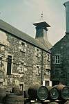 | |||
| 4 Agnew Crescent | 54°52′01″N 4°26′40″W | Category C(S) | 43767 | | |||
| 22 Bladnoch Village | 54°51′29″N 4°27′33″W | Category C(S) | 42376 | | |||
| 23 Bladnoch Village | 54°51′29″N 4°27′34″W | Category C(S) | 42377 | | |||
| 25 Bladnoch Village Riverside | 54°51′29″N 4°27′35″W | Category B | 42379 | | |||
| 33 Bladnoch Village | 54°51′30″N 4°27′39″W | Category B | 42384 | | |||
| Church Lane, The Laigh House (Former Manse) | 54°52′16″N 4°26′26″W | Category C(S) | 42386 | | |||
| Dunure House Boundary Walls Gates And Outbuildings | 54°51′54″N 4°26′40″W | Category B | 42387 | | |||
| 4 North Main Street The Red Lion Inn | 54°52′08″N 4°26′32″W | Category C(S) | 42402 | | |||
| South Main Street Sacred Heart R.C. Church With Gates Gateposts,Railings And Boundary Walls | 54°52′04″N 4°26′31″W | Category C(S) | 42420 | | |||
| 4 South Main Street And Garden Wall | 54°52′07″N 4°26′28″W | Category B | 42421 | | |||
| 15 South Main Street | 54°52′05″N 4°26′32″W | Category C(S) | 42425 | | |||
| 28 South Main Street Craiglachie | 54°52′03″N 4°26′38″W | Category B | 42433 | | |||
| 33 And 34 South Main Street | 54°52′02″N 4°26′40″W | Category C(S) | 42436 | | |||
| 9 Agnew Crescent | 54°52′00″N 4°26′41″W | Category C(S) | 42337 | | |||
| 8 Agnew Crescent | 54°52′01″N 4°26′39″W | Category C(S) | 42344 | | |||
| 12 Bladnoch Village | 54°51′29″N 4°27′28″W | Category C(S) | 42369 | |
Key
The scheme for classifying buildings in Scotland is:
- Category A: "buildings of national or international importance, either architectural or historic; or fine, little-altered examples of some particular period, style or building type."[1]
- Category B: "buildings of regional or more than local importance; or major examples of some particular period, style or building type, which may have been altered."[1]
- Category C: "buildings of local importance; lesser examples of any period, style, or building type, as originally constructed or moderately altered; and simple traditional buildings which group well with other listed buildings."[1]
In March 2016 there were 47,288 listed buildings in Scotland. Of these, 8 per cent were Category A, and 50 per cent were Category B, with the rest listed at Category C.[2]
Notes
- Sometimes known as OSGB36, the grid reference (where provided) is based on the British national grid reference system used by the Ordnance Survey.
• "Guide to National Grid". Ordnance Survey. Retrieved 12 December 2007.
• "Get-a-map". Ordnance Survey. Retrieved 17 December 2007. - Historic Environment Scotland assign a unique alphanumeric identifier to each designated site in Scotland, for listed buildings this always begins with "LB", for example "LB12345".
References
- All entries, addresses and coordinates are based on data from Historic Scotland. This data falls under the Open Government Licence
- "What is Listing?". Historic Environment Scotland. Retrieved 29 May 2018.
- Scotland's Historic Environment Audit 2016 (PDF). Historic Environment Scotland and the Built Environment Forum Scotland. pp. 15–16. Retrieved 29 May 2018.
| Wikimedia Commons has media related to Wigtown. |
This article is issued from Wikipedia. The text is licensed under Creative Commons - Attribution - Sharealike. Additional terms may apply for the media files.