List of listed buildings in Tinwald, Dumfries and Galloway
This is a list of listed buildings in the civil parish of Tinwald in Dumfries and Galloway, Scotland.
List
| Name | Location | Date Listed | Grid Ref. [note 1] | Geo-coordinates | Notes | LB Number [note 2] | Image |
|---|---|---|---|---|---|---|---|
| Ae Bridge (A701 Over Water Of Ae) | 55°09′56″N 3°33′15″W | Category B | 17231 |  | |||
| Tinwaldshaws Farmhouse | 55°06′47″N 3°32′44″W | Category B | 17244 | | |||
| Amisfield House Former Stables | 55°08′17″N 3°35′04″W | Category B | 17236 | | |||
| Tinwald Parish Church, And Churchyard | 55°07′09″N 3°33′56″W | Category B | 17241 | | |||
| Amisfield House | 55°08′17″N 3°34′58″W | Category B | 17232 | | |||
| Amisfield Lodge & Gatepiers | 55°08′06″N 3°34′51″W | Category C(S) | 17235 | | |||
| Tinwald House Cottages | 55°06′24″N 3°32′30″W | Category A | 17239 | | |||
| Glenae House And Gatepiers | 55°08′40″N 3°35′13″W | Category B | 17237 | | |||
| Tinwald House | 55°06′26″N 3°32′31″W | Category A | 17238 | 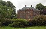 | |||
| Amisfield Garden Walls | 55°08′19″N 3°34′56″W | Category B | 17234 | | |||
| Amisfield Tower | 55°08′18″N 3°34′58″W | Category A | 17233 | | |||
| Tinwald House Farm Steading (Original 2-Storey L-Plan Block Only) | 55°06′27″N 3°32′34″W | Category A | 17240 | | |||
| Tinwald Old Manse And Flanking Wings | 55°07′06″N 3°34′11″W | Category C(S) | 17243 | | |||
| Trailflat Churchyard | 55°08′30″N 3°29′42″W | Category C(S) | 17205 | | |||
| Tinwald Parish Manse | 55°07′03″N 3°34′13″W | Category B | 17242 | |
Key
The scheme for classifying buildings in Scotland is:
- Category A: "buildings of national or international importance, either architectural or historic; or fine, little-altered examples of some particular period, style or building type."[1]
- Category B: "buildings of regional or more than local importance; or major examples of some particular period, style or building type, which may have been altered."[1]
- Category C: "buildings of local importance; lesser examples of any period, style, or building type, as originally constructed or moderately altered; and simple traditional buildings which group well with other listed buildings."[1]
In March 2016 there were 47,288 listed buildings in Scotland. Of these, 8 per cent were Category A, and 50 per cent were Category B, with the rest listed at Category C.[2]
Notes
- Sometimes known as OSGB36, the grid reference (where provided) is based on the British national grid reference system used by the Ordnance Survey.
• "Guide to National Grid". Ordnance Survey. Retrieved 2007-12-12.
• "Get-a-map". Ordnance Survey. Retrieved 2007-12-17. - Historic Environment Scotland assign a unique alphanumeric identifier to each designated site in Scotland, for listed buildings this always begins with "LB", for example "LB12345".
References
- All entries, addresses and coordinates are based on data from Historic Scotland. This data falls under the Open Government Licence
- "What is Listing?". Historic Environment Scotland. Retrieved 29 May 2018.
- Scotland's Historic Environment Audit 2016 (PDF). Historic Environment Scotland and the Built Environment Forum Scotland. pp. 15–16. Retrieved 29 May 2018.
| Wikimedia Commons has media related to Tinwald. |
This article is issued from Wikipedia. The text is licensed under Creative Commons - Attribution - Sharealike. Additional terms may apply for the media files.