List of listed buildings in New Abbey, Dumfries and Galloway
This is a list of listed buildings in the civil parish of New Abbey in Dumfries and Galloway, Scotland.
List
| Name | Location | Date Listed | Grid Ref. [note 1] | Geo-coordinates | Notes | LB Number [note 2] | Image |
|---|---|---|---|---|---|---|---|
| Carse Farmhouse And Steading Range Adjoining To South West | 54°58′33″N 3°35′59″W | Category C(S) | 17315 |  | |||
| New Abbey Village New Abbey Mill | 54°58′48″N 3°37′23″W | Category A | 17323 |  | |||
| Mossyard Cottage And Former Steading | 54°59′12″N 3°40′35″W | Category C(S) | 17342 | | |||
| New Abbey Village The Square M J Carberry's Shop/Post Office, House And Warehouse | 54°58′48″N 3°37′19″W | Category C(S) | 17302 |  | |||
| Kinharvie House And Chapel | 54°59′02″N 3°40′39″W | Category C(S) | 17309 | | |||
| New Abbey Village Kindar Lodge | 54°58′38″N 3°37′14″W | Category B | 17318 | | |||
| New Abbey Village New Abbey Parish Church | 54°58′39″N 3°37′06″W | Category B | 17324 | | |||
| New Abbey Village Abbey House | 54°58′47″N 3°37′21″W | Category B | 17343 | | |||
| New Abbey Village Abbey House Garden Walls | 54°58′47″N 3°37′21″W | Category B | 17344 | | |||
| 6-11 (Inclusive Nos), The Square Including Old Smithy And Former Weigh- House | 54°58′47″N 3°37′18″W | Category C(S) | 49586 | | |||
| New Abbey Village Sweetheart Abbey And Precinct Walls | 54°58′49″N 3°37′07″W | Category A | 17304 | .JPG) | |||
| Glenharvie House Dovecot | 54°58′52″N 3°37′57″W | Category C(S) | 17308 | | |||
| New Abbey Village New Abbey Parish Manse 28 Main Street | 54°58′47″N 3°37′09″W | Category B | 17310 | | |||
| West Shambellie Pottery (Former Bacon Factory) | 54°59′19″N 3°37′37″W | Category B | 17313 | | |||
| New Abbey Village Kindar House | 54°58′33″N 3°37′12″W | Category B | 17317 | | |||
| New Abbey Village Church House | 54°58′47″N 3°37′24″W | Category B | 17345 | | |||
| New Abbey Village St Mary's Rc Church And Presbytery | 54°58′43″N 3°36′58″W | Category B | 17311 | | |||
| New Abbey Village 21 Main Street Devorgilla Cottage And Outbuilding To West | 54°58′48″N 3°37′12″W | Category B | 17320 | | |||
| New Abbey Village Main Street Rosewall | 54°58′48″N 3°37′14″W | Category C(S) | 17321 | | |||
| New Abbey Village The Old House | 54°58′47″N 3°37′25″W | Category A | 17346 |  | |||
| New Abbey Village 5 Main Street Port House | 54°58′48″N 3°37′17″W | Category B | 17319 | | |||
| New Abbey Village New Abbey Bridge (A710 Over New Abbey Pow) | 54°58′50″N 3°37′23″W | Category B | 17322 |  | |||
| New Abbey Village Kindar Cottages | 54°58′38″N 3°37′10″W | Category B | 17347 | | |||
| New Abbey Village 5 The Square | 54°58′47″N 3°37′19″W | Category C(S) | 17303 | | |||
| Shambellie House | 54°59′00″N 3°37′33″W | Category B | 17306 | | |||
| Shambellie House Lodge And Gatepiers | 54°58′58″N 3°37′22″W | Category B | 17307 | | |||
| Beeswing Village Lochend Church | 55°00′20″N 3°43′46″W | Category C(S) | 17314 |  | |||
| Shambellie Grange Archway | 54°59′07″N 3°37′11″W | Category B | 17305 | | |||
| Glenharvie House, Screen Wall And Outbuildings | 54°58′53″N 3°37′56″W | Category B | 17316 | | |||
| Sweetheart Abbey Cemetery | 54°58′49″N 3°37′04″W | Category C(S) | 49587 | | |||
| Waterloo Monument | 54°58′26″N 3°38′17″W | Category B | 17312 | 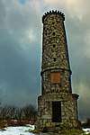 | |||
| Shambellie House Walled Garden | 54°58′55″N 3°37′34″W | Category C(S) | 17331 | | |||
| Shambellie House Hollinbush Cottage And Outbuildings (Formerly Shambellie Offices And Coachman's House) | 54°58′52″N 3°37′22″W | Category C(S) | 17332 | |
Key
The scheme for classifying buildings in Scotland is:
- Category A: "buildings of national or international importance, either architectural or historic; or fine, little-altered examples of some particular period, style or building type."[1]
- Category B: "buildings of regional or more than local importance; or major examples of some particular period, style or building type, which may have been altered."[1]
- Category C: "buildings of local importance; lesser examples of any period, style, or building type, as originally constructed or moderately altered; and simple traditional buildings which group well with other listed buildings."[1]
In March 2016 there were 47,288 listed buildings in Scotland. Of these, 8 per cent were Category A, and 50 per cent were Category B, with the rest listed at Category C.[2]
Notes
- Sometimes known as OSGB36, the grid reference (where provided) is based on the British national grid reference system used by the Ordnance Survey.
• "Guide to National Grid". Ordnance Survey. Retrieved 2007-12-12.
• "Get-a-map". Ordnance Survey. Retrieved 2007-12-17. - Historic Environment Scotland assign a unique alphanumeric identifier to each designated site in Scotland, for listed buildings this always begins with "LB", for example "LB12345".
References
- All entries, addresses and coordinates are based on data from Historic Scotland. This data falls under the Open Government Licence
- "What is Listing?". Historic Environment Scotland. Retrieved 29 May 2018.
- Scotland's Historic Environment Audit 2016 (PDF). Historic Environment Scotland and the Built Environment Forum Scotland. pp. 15–16. Retrieved 29 May 2018.
| Wikimedia Commons has media related to New Abbey. |
This article is issued from Wikipedia. The text is licensed under Creative Commons - Attribution - Sharealike. Additional terms may apply for the media files.