List of listed buildings in Kelton, Dumfries and Galloway
List
| Name | Location | Date Listed | Grid Ref. [note 1] | Geo-coordinates | Notes | LB Number [note 2] | Image |
|---|---|---|---|---|---|---|---|
| Slatehole | 54°55′11″N 3°57′34″W | Category B | 9827 |  | |||
| Billies Farmhouse | 54°53′39″N 3°59′25″W | Category B | 9833 | | |||
| Douglas Mausoleum, Near To Kelton Parish Church, Railings And Gatepiers | 54°55′20″N 3°56′18″W | Category A | 9835 | 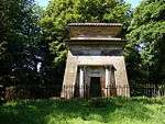 | |||
| Gelston Castle Estate, Gelston Coach House And Gatepiers | 54°54′13″N 3°54′35″W | Category B | 9837 | | |||
| Kelton Old Church In Old Churchyard | 54°55′15″N 3°56′05″W | Category C(S) | 9821 | | |||
| Kelton Parish Church | 54°55′17″N 3°56′15″W | Category B | 9822 | | |||
| Ingleston | 54°54′05″N 3°54′55″W | Category B | 9817 | | |||
| Rhonehouse, Rodney House | 54°55′02″N 3°57′48″W | Category C(S) | 9826 | | |||
| Threave Bridge | 54°55′18″N 3°58′18″W | Category B | 9828 | | |||
| Kelton Mill, Byre | 54°55′17″N 3°57′32″W | Category C(S) | 9820 | | |||
| Threave House | 54°55′22″N 3°56′51″W | Category B | 9829 |  | |||
| Threave Stables | 54°55′29″N 3°56′56″W | Category B | 9830 | | |||
| Dildawn House And Walled Garden | 54°54′43″N 3°59′13″W | Category B | 9834 | | |||
| Old Bridge Of Dee | 54°55′06″N 3°58′34″W | Category A | 9838 | .jpg) | |||
| Kelton Mains Farm | 54°56′03″N 3°57′33″W | Category B | 9818 | | |||
| Airieland Farm House | 54°53′40″N 3°56′20″W | Category B | 9831 | | |||
| Gelston Castle | 54°54′17″N 3°54′31″W | Category A | 9836 | 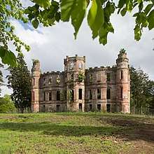 | |||
| Gelston Castle Estate, Gelston Stables And Walled Gardens | 54°54′14″N 3°54′34″W | Category B | 9816 | 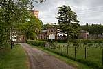 | |||
| Kelton Mill | 54°55′18″N 3°57′31″W | Category C(S) | 9819 | | |||
| Rhonehouse, Creaghlas | 54°55′03″N 3°57′46″W | Category C(S) | 9824 | | |||
| Rhonehouse Of Kelton, Millhill | 54°55′03″N 3°57′44″W | Category B | 9825 | | |||
| Rhonehouse, An Teallach | 54°55′00″N 3°57′49″W | Category C(S) | 9823 | | |||
| Airieland House | 54°53′42″N 3°56′14″W | Category B | 9832 | |
Key
The scheme for classifying buildings in Scotland is:
- Category A: "buildings of national or international importance, either architectural or historic; or fine, little-altered examples of some particular period, style or building type."[1]
- Category B: "buildings of regional or more than local importance; or major examples of some particular period, style or building type, which may have been altered."[1]
- Category C: "buildings of local importance; lesser examples of any period, style, or building type, as originally constructed or moderately altered; and simple traditional buildings which group well with other listed buildings."[1]
In March 2016 there were 47,288 listed buildings in Scotland. Of these, 8 per cent were Category A, and 50 per cent were Category B, with the rest listed at Category C.[2]
Notes
- Sometimes known as OSGB36, the grid reference (where provided) is based on the British national grid reference system used by the Ordnance Survey.
• "Guide to National Grid". Ordnance Survey. Retrieved 2007-12-12.
• "Get-a-map". Ordnance Survey. Retrieved 2007-12-17. - Historic Environment Scotland assign a unique alphanumeric identifier to each designated site in Scotland, for listed buildings this always begins with "LB", for example "LB12345".
References
- All entries, addresses and coordinates are based on data from Historic Scotland. This data falls under the Open Government Licence
- "What is Listing?". Historic Environment Scotland. Retrieved 29 May 2018.
- Scotland's Historic Environment Audit 2016 (PDF). Historic Environment Scotland and the Built Environment Forum Scotland. pp. 15–16. Retrieved 29 May 2018.
| Wikimedia Commons has media related to Kelton. |
This article is issued from Wikipedia. The text is licensed under Creative Commons - Attribution - Sharealike. Additional terms may apply for the media files.