List of listed buildings in Kirkpatrick-Juxta, Dumfries and Galloway
This is a list of listed buildings in the parish of Kirkpatrick-Juxta in Dumfries and Galloway, Scotland.
List
| Name | Location | Date Listed | Grid Ref. [note 1] | Geo-coordinates | Notes | LB Number [note 2] | Image |
|---|---|---|---|---|---|---|---|
| Beattock Village, Evan Bridge | 55°18′38″N 3°27′20″W | Category C(S) | 9907 |  | |||
| Chapel Farm Cottages And Fragments Of St Cuthbert's Chapel | 55°20′05″N 3°27′40″W | Category B | 9841 | | |||
| Craigielands House | 55°17′58″N 3°27′22″W | Category A | 9842 | | |||
| Craigielands, Former Stables | 55°18′01″N 3°27′27″W | Category B | 9847 | | |||
| Skellywell Mill | 55°18′50″N 3°27′36″W | Category C(S) | 13324 | | |||
| Kirkpatrick Juxta Former Parish Manse And Outbuildings | 55°17′36″N 3°26′50″W | Category C(S) | 9892 | | |||
| Craigielands, Walled Garden And Gardener's House And Semi-Domed Alcove | 55°17′49″N 3°27′16″W | Category B | 9846 | | |||
| Lochhouse Tower | 55°18′57″N 3°26′55″W | Category B | 9894 | | |||
| Milton Farmhouse | 55°17′32″N 3°25′38″W | Category C(S) | 9896 | | |||
| Beattock Village, Beattock House Hotel And Gatepiers To North And To South | 55°18′34″N 3°27′09″W | Category B | 9906 | | |||
| Craigielands South Lodge And Gatepiers | 55°17′45″N 3°27′01″W | Category B | 9845 | | |||
| Evan Bridge Near Auchen Castle | 55°19′29″N 3°28′17″W | Category C(S) | 9849 | | |||
| Valenciennes | 55°19′08″N 3°28′10″W | Category B | 9897 | | |||
| Beattock Village, Beattock School | 55°18′18″N 3°27′05″W | Category C(S) | 9840 | | |||
| Auchen Castle Hotel And Garden Terrace Steps Balustrades | 55°19′39″N 3°28′45″W | Category B | 9889 | | |||
| Longbedholm Bridge | 55°20′29″N 3°29′31″W | Category C(S) | 9895 | | |||
| Beattock Village, Beattock Bridge | 55°18′37″N 3°27′15″W | Category B | 9905 | | |||
| Beattock Village, The Old Brig Inn, Hotel And Outbuildings | 55°18′38″N 3°27′18″W | Category A | 9908 | 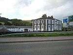 | |||
| Dyke Farmhouse | 55°19′04″N 3°26′33″W | Category C(S) | 9848 | | |||
| Kirkpatrick-Juxta Parish Church And Churchyard | 55°17′39″N 3°26′46″W | Category B | 9850 | | |||
| Langshawbush House, Coach House And Gatepiers | 55°19′33″N 3°26′48″W | Category B | 9893 | | |||
| Beattock Village, Former Stationmaster's House | 55°18′25″N 3°27′17″W | Category B | 9839 | | |||
| Kirkpartrick Juxta Parish Manse | 55°17′36″N 3°26′46″W | Category C(S) | 9891 | | |||
| Auchen Castle Lodge, Gatepiers And Quadrants | 55°19′27″N 3°28′33″W | Category B | 9904 | | |||
| Craigielands, Ice House | 55°17′52″N 3°27′14″W | Category C(S) | 9843 | | |||
| Craigielands, North Lodge And Gatepiers | 55°18′12″N 3°27′11″W | Category B | 9844 | |
Key
The scheme for classifying buildings in Scotland is:
- Category A: "buildings of national or international importance, either architectural or historic; or fine, little-altered examples of some particular period, style or building type."[1]
- Category B: "buildings of regional or more than local importance; or major examples of some particular period, style or building type, which may have been altered."[1]
- Category C: "buildings of local importance; lesser examples of any period, style, or building type, as originally constructed or moderately altered; and simple traditional buildings which group well with other listed buildings."[1]
In March 2016 there were 47,288 listed buildings in Scotland. Of these, 8 per cent were Category A, and 50 per cent were Category B, with the rest listed at Category C.[2]
Notes
- Sometimes known as OSGB36, the grid reference (where provided) is based on the British national grid reference system used by the Ordnance Survey.
• "Guide to National Grid". Ordnance Survey. Retrieved 2007-12-12.
• "Get-a-map". Ordnance Survey. Retrieved 2007-12-17. - Historic Environment Scotland assign a unique alphanumeric identifier to each designated site in Scotland, for listed buildings this always begins with "LB", for example "LB12345".
References
- All entries, addresses and coordinates are based on data from Historic Scotland. This data falls under the Open Government Licence
- "What is Listing?". Historic Environment Scotland. Retrieved 29 May 2018.
- Scotland's Historic Environment Audit 2016 (PDF). Historic Environment Scotland and the Built Environment Forum Scotland. pp. 15–16. Retrieved 29 May 2018.
This article is issued from Wikipedia. The text is licensed under Creative Commons - Attribution - Sharealike. Additional terms may apply for the media files.