List of listed buildings in Whithorn, Dumfries and Galloway
This is a list of listed buildings in the civil parish of Whithorn, in Dumfries and Galloway, Scotland.
List
| Name | Location | Date Listed | Grid Ref. [note 1] | Geo-coordinates | Notes | LB Number [note 2] | Image |
|---|---|---|---|---|---|---|---|
| 107 George Street | 54°43′54″N 4°25′01″W | Category B | 43766 |  | |||
| 51 George Street | 54°43′59″N 4°24′57″W | Category C(S) | 42194 | | |||
| 53 George Street And Entrance To Priory | 54°43′59″N 4°24′57″W | Category A | 42195 | 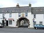 | |||
| 55-57 (Odd Nos) George Street | 54°43′59″N 4°24′57″W | Category A | 42196 | | |||
| 65, 67 And 69 George Street, Including Old Town Hall And Bell Tower | 54°43′58″N 4°24′59″W | Category B | 42197 |  | |||
| 77 George Street, The Clydesdale Bank, Walls And Railings | 54°43′56″N 4°24′59″W | Category C(S) | 42200 | | |||
| 79 George Street | 54°43′56″N 4°24′59″W | Category B | 42201 | | |||
| 83 George Street | 54°43′56″N 4°24′59″W | Category C(S) | 42203 | | |||
| 101 George Street | 54°43′54″N 4°25′01″W | Category C(S) | 42210 | | |||
| 8 George Street | 54°44′03″N 4°24′52″W | Category B | 42220 | | |||
| 58 George Street | 54°43′58″N 4°24′56″W | Category C(S) | 42234 | | |||
| 118 George Street | 54°43′52″N 4°25′01″W | Category C(S) | 42251 | | |||
| 122 George Street | 54°43′51″N 4°25′02″W | Category C(S) | 42253 | | |||
| 25 St John Street | 54°44′09″N 4°24′53″W | Category B | 42259 | | |||
| 70 St John Street | 54°44′04″N 4°24′52″W | Category C(S) | 42263 | | |||
| Isle Of Whithorn, 66-70 (Even Nos) Main Street | 54°41′59″N 4°21′45″W | Category C(S) | 19238 | | |||
| Isle Of Whithorn, 76-78 (Even Nos) Main Street | 54°41′58″N 4°21′44″W | Category C(S) | 19240 | | |||
| Reiffer Park With Retaining Walls | 54°46′42″N 4°25′09″W | Category B | 19247 | | |||
| Isle Of Whithorn, 38 Main Street, Low Isle House | 54°42′03″N 4°21′55″W | Category B | 17070 | | |||
| Isle Of Whithorn, Isle Parish Church (Church Of Scotland) | 54°41′58″N 4°21′46″W | Category B | 16722 | | |||
| 71 And 73 George Street | 54°43′57″N 4°24′58″W | Category B | 42198 | | |||
| 81 George Street | 54°43′56″N 4°24′59″W | Category C(S) | 42202 | | |||
| 85 George Street | 54°43′55″N 4°24′59″W | Category C(S) | 42204 | | |||
| 91-93 (Odd Nos) George Street | 54°43′55″N 4°25′01″W | Category C(S) | 42207 | | |||
| 109 George Street | 54°43′53″N 4°25′02″W | Category B | 42212 | | |||
| 2 George Street (Corner With St John Street) The Cross House | 54°44′04″N 4°24′52″W | Category C(S) | 42217 | | |||
| 12-14 (Even Nos) George Street And Rubble Wall To Rear | 54°44′02″N 4°24′53″W | Category B | 42222 | | |||
| 26 George Street | 54°44′01″N 4°24′54″W | Category B | 42226 | | |||
| 30-32 (Even Nos) George Street | 54°44′00″N 4°24′54″W | Category B | 42228 | | |||
| 60 George Street | 54°43′58″N 4°24′56″W | Category B | 42235 | | |||
| 96 And 98 George Street | 54°43′54″N 4°24′58″W | Category C(S) | 42241 | | |||
| 102 George Street | 54°43′53″N 4°24′59″W | Category B | 42243 | | |||
| 112 George Street | 54°43′52″N 4°25′01″W | Category B | 42248 | | |||
| 114 George Street | 54°43′52″N 4°25′01″W | Category C(S) | 42249 | | |||
| 126 George Street | 54°43′51″N 4°25′02″W | Category B | 42255 | | |||
| 33 High Street | 54°43′46″N 4°25′08″W | Category C(S) | 42258 | | |||
| 53 St John Street, Whithorn Town Hall With Gate, Railings And Quadrant Wall | 54°44′06″N 4°24′54″W | Category C(S) | 42261 | | |||
| Whithorn Priory | 54°44′01″N 4°25′01″W | Category A | 42266 |  | |||
| Isle Of Whithorn, 24-30 (Even Nos) Main Street | 54°42′03″N 4°21′59″W | Category C(S) | 19233 | | |||
| Isle Of Whithorn, 86 Main Street | 54°41′57″N 4°21′42″W | Category C(S) | 19243 | | |||
| Isle Of Whithorn, 12 Main Street | 54°42′04″N 4°22′03″W | Category C(S) | 16724 | | |||
| Isle Of Whithorn, 14 Main Street | 54°42′04″N 4°22′03″W | Category C(S) | 16725 | | |||
| Castlewigg Steading, Principal Range | 54°45′33″N 4°26′48″W | Category C(S) | 16750 | | |||
| Bruce Street, Museum And Custodian's House And Boundary Walls | 54°44′00″N 4°25′00″W | Category B | 42185 | | |||
| 17 George Street, The Central Cafe | 54°44′02″N 4°24′55″W | Category C(S) | 42191 | | |||
| 89 George Street | 54°43′55″N 4°25′00″W | Category B | 42206 | | |||
| 111-113 (Odd Nos) George Street | 54°43′53″N 4°25′02″W | Category C(S) | 42213 | | |||
| 137 George Street | 54°43′51″N 4°25′04″W | Category B | 42216 | | |||
| 56 George Street | 54°43′58″N 4°24′56″W | Category C(S) | 42233 | | |||
| 108 George Street | 54°43′53″N 4°25′00″W | Category B | 42246 | | |||
| 130 George Street | 54°43′50″N 4°25′02″W | Category C(S) | 42257 | | |||
| Whithorn Manse | 54°44′04″N 4°25′09″W | Category B | 42264 | | |||
| Isle Of Whithorn, 80 Main Street | 54°41′58″N 4°21′43″W | Category C(S) | 19241 | | |||
| Isle Of Whithorn, Isle Castle | 54°42′05″N 4°21′57″W | Category A | 16751 | | |||
| Isle Of Whithorn, Harbour Row, Warehouses Including Isle Smugglers | 54°41′54″N 4°21′46″W | Category B | 16755 | | |||
| 11 George Street | 54°44′02″N 4°24′54″W | Category C(S) | 42189 | | |||
| 28 George Street | 54°44′01″N 4°24′54″W | Category B | 42227 | | |||
| 52-54 (Even Nos) George Street | 54°43′58″N 4°24′55″W | Category C(S) | 42232 | | |||
| 94 George Street | 54°43′54″N 4°24′58″W | Category B | 42240 | | |||
| 120 George Street | 54°43′52″N 4°25′01″W | Category C(S) | 42252 | | |||
| Whithorn Parish Church, (Church Of Scotland) And Graveyard | 54°44′02″N 4°25′03″W | Category B | 42265 | | |||
| Isle Of Whithorn, 5 Tonderghie Road | 54°42′02″N 4°22′02″W | Category C(S) | 19246 | | |||
| Tonderghie House | 54°41′31″N 4°25′02″W | Category A | 19248 | 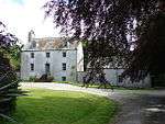 | |||
| Isle Of Whithorn, 16 Main Street | 54°42′04″N 4°22′02″W | Category B | 16726 | | |||
| Broughton Mains Farmhouse | 54°46′34″N 4°24′34″W | Category B | 16740 | | |||
| Isle Of Whithorn, Harbour | 54°41′53″N 4°21′48″W | Category B | 16753 | | |||
| 7-9 (Odd Nos) George Street | 54°44′03″N 4°24′54″W | Category B | 42188 | | |||
| 103-105 (Odd Nos) George Street | 54°43′54″N 4°25′01″W | Category C(S) | 42211 | | |||
| 6 George Street | 54°44′03″N 4°24′52″W | Category B | 42219 | | |||
| 16-18 (Even Nos) George Street | 54°44′01″N 4°24′53″W | Category B | 42223 | | |||
| 34 George Street | 54°44′00″N 4°24′54″W | Category B | 42229 | | |||
| 36 And 38 George Street | 54°44′00″N 4°24′55″W | Category C(S) | 42230 | | |||
| Isle Of Whithorn, 20 Main Street | 54°42′03″N 4°22′02″W | Category B | 19231 | | |||
| Isle Of Whithorn, 62 Main Street | 54°41′59″N 4°21′45″W | Category C(S) | 19236 | | |||
| Isle Of Whithorn, 64 Main Street | 54°41′59″N 4°21′45″W | Category C(S) | 19237 | | |||
| Isle Of Whithorn, 72-74 (Even Nos) Main Street | 54°41′59″N 4°21′44″W | Category C(S) | 19239 | | |||
| Isle Of Whithorn, 82 Main Street | 54°41′58″N 4°21′43″W | Category B | 19242 | | |||
| Isle Of Whithorn, 3 Tonderghie Road | 54°42′02″N 4°22′02″W | Category B | 19245 | | |||
| Isle Of Whithorn, Harbour Row, Harbour House, The Wigtown Bay Sailing Club | 54°41′57″N 4°21′44″W | Category C(S) | 16754 | | |||
| Castlewigg Castle | 54°45′32″N 4°26′42″W | Category B | 16741 | | |||
| 5 George Street | 54°44′03″N 4°24′54″W | Category C(S) | 42187 | | |||
| 19 George Street, The Royal Bank Of Scotland | 54°44′02″N 4°24′55″W | Category C(S) | 42192 | | |||
| 99 George Street | 54°43′54″N 4°25′00″W | Category C(S) | 42209 | | |||
| 125-127 (Odd Nos) George Street | 54°43′52″N 4°25′03″W | Category B | 42214 | | |||
| 129 George Street | 54°43′51″N 4°25′04″W | Category B | 42215 | | |||
| 70 And 72 George Street | 54°43′56″N 4°24′56″W | Category B | 42238 | | |||
| 124 George Street | 54°43′51″N 4°25′02″W | Category C(S) | 42254 | | |||
| Isle Of Whithorn, 58 Main Street | 54°42′00″N 4°21′46″W | Category C(S) | 19234 | | |||
| Tonderghie Steadings | 54°41′22″N 4°25′07″W | Category A | 19249 | | |||
| Isle Of Whithorn, St Ninians Kirk | 54°41′53″N 4°21′39″W | Category B | 16723 | 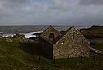 | |||
| Isle Of Whithorn, 13 Main Street, Captain's Garden, Formerly Sea View | 54°42′01″N 4°21′48″W | Category B | 43736 | | |||
| 29 George Street And Walled Garden | 54°44′01″N 4°24′55″W | Category B | 42193 | | |||
| 87 George Street | 54°43′55″N 4°25′00″W | Category C(S) | 42205 | | |||
| 4 George Street | 54°44′03″N 4°24′52″W | Category B | 42218 | | |||
| George Street, The Grapes Hotel | 54°44′02″N 4°24′53″W | Category C(S) | 42221 | | |||
| 22 And 24 George Street | 54°44′01″N 4°24′53″W | Category B | 42225 | | |||
| 42-44 (Even Nos) George Street | 54°43′59″N 4°24′55″W | Category C(S) | 42231 | | |||
| 92 George Street | 54°43′55″N 4°24′58″W | Category B | 42239 | | |||
| 104 George Street | 54°43′53″N 4°25′00″W | Category C(S) | 42244 | | |||
| 106 George Street | 54°43′53″N 4°25′00″W | Category C(S) | 42245 | | |||
| 128 George Street | 54°43′51″N 4°25′02″W | Category C(S) | 42256 | | |||
| 27 St John Street, "The Neuk" And Boundary Walls | 54°44′09″N 4°24′54″W | Category B | 42260 | | |||
| Isle Of Whithorn, 22 Main Street, The Queens Arms | 54°42′03″N 4°22′01″W | Category C(S) | 19232 | | |||
| Castlewigg Hotel | 54°45′22″N 4°26′11″W | Category B | 16742 | | |||
| Isle Of Whithorn, Isle Farm | 54°42′35″N 4°21′41″W | Category B | 16752 | | |||
| Isle Of Whithorn, 5 Main Street | 54°42′03″N 4°22′02″W | Category C(S) | 44188 | | |||
| Isle Of Whithorn, 88 Main Street | 54°41′57″N 4°21′42″W | Category C(S) | 43737 | | |||
| 13-15 (Odd Nos) George Street | 54°44′02″N 4°24′55″W | Category B | 42190 | | |||
| 75 George Street, Registrar's Office | 54°43′57″N 4°24′58″W | Category B | 42199 | | |||
| 97 George Street | 54°43′55″N 4°25′00″W | Category B | 42208 | | |||
| 20 George Street | 54°44′01″N 4°24′53″W | Category B | 42224 | | |||
| 62-64 (Even Nos) George Street | 54°43′57″N 4°24′56″W | Category C(S) | 42236 | | |||
| Post Office, 68 George Street | 54°43′57″N 4°24′56″W | Category B | 42237 | | |||
| 100 George Street | 54°43′54″N 4°24′59″W | Category B | 42242 | | |||
| 110 George Street | 54°43′52″N 4°25′01″W | Category B | 42247 | | |||
| 116 George Street | 54°43′52″N 4°25′01″W | Category C(S) | 42250 | | |||
| 22 St John Street, St John's Garage (Former Up Church) | 54°44′11″N 4°24′52″W | Category C(S) | 42262 | 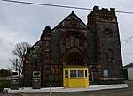 | |||
| Isle Of Whithorn, 60 Main Street | 54°42′00″N 4°21′45″W | Category C(S) | 19235 | | |||
| Isle Of Whithorn, Sea Breeze And Rosnay, With Sea Wall | 54°42′01″N 4°21′49″W | Category C(S) | 19244 | | |||
| Isle Of Whithorn, 56 Main Street | 54°42′00″N 4°21′46″W | Category B | 17071 | | |||
| Isle Of Whithorn, 18 Main Street | 54°42′03″N 4°22′02″W | Category B | 16727 | | |||
| George Street, St Martin And St Ninian Roman Catholic Church, Including Quadrant Walls | 54°43′55″N 4°24′57″W | Category C(S) | 51291 | |
Key
The scheme for classifying buildings in Scotland is:
- Category A: "buildings of national or international importance, either architectural or historic; or fine, little-altered examples of some particular period, style or building type."[1]
- Category B: "buildings of regional or more than local importance; or major examples of some particular period, style or building type, which may have been altered."[1]
- Category C: "buildings of local importance; lesser examples of any period, style, or building type, as originally constructed or moderately altered; and simple traditional buildings which group well with other listed buildings."[1]
In March 2016 there were 47,288 listed buildings in Scotland. Of these, 8 per cent were Category A, and 50 per cent were Category B, with the rest listed at Category C.[2]
Notes
- Sometimes known as OSGB36, the grid reference (where provided) is based on the British national grid reference system used by the Ordnance Survey.
• "Guide to National Grid". Ordnance Survey. Retrieved 2007-12-12.
• "Get-a-map". Ordnance Survey. Retrieved 2007-12-17. - Historic Environment Scotland assign a unique alphanumeric identifier to each designated site in Scotland, for listed buildings this always begins with "LB", for example "LB12345".
References
- All entries, addresses and coordinates are based on data from Historic Scotland. This data falls under the Open Government Licence
- "What is Listing?". Historic Environment Scotland. Retrieved 29 May 2018.
- Scotland's Historic Environment Audit 2016 (PDF). Historic Environment Scotland and the Built Environment Forum Scotland. pp. 15–16. Retrieved 29 May 2018.
| Wikimedia Commons has media related to Whithorn. |
This article is issued from Wikipedia. The text is licensed under Creative Commons - Attribution - Sharealike. Additional terms may apply for the media files.