List of listed buildings in Dalton, Dumfries and Galloway
This is a list of listed buildings in the parish of Dalton in Dumfries and Galloway, Scotland.
| Wikimedia Commons has media related to Dalton, Dumfries and Galloway. |
List
| Name | Location | Date Listed | Grid Ref. [note 1] | Geo-coordinates | Notes | LB Number [note 2] | Image |
|---|---|---|---|---|---|---|---|
| Kirkwood House, Former Stables including Horsemill, Cottages and Kennels | 55°03′43″N 3°22′50″W | Category C(S) | 3373 |  | |||
| Almagill Hill, Monument to Joe Graham | 55°04′06″N 3°25′40″W | Category B | 3452 | | |||
| Dalton Village, Dalton Old Parish Church, Churchyard and Gatepiers | 55°03′09″N 3°23′17″W | Category A | 3455 | .jpg) | |||
| Dalton Village, Kobe and Stan Court and Garage adjoining | 55°03′10″N 3°23′17″W | Category C(S) | 3456 | | |||
| Rammerscales, Former Stables | 55°05′02″N 3°26′24″W | Category B | 3796 | | |||
| Manse Bridge (Minor Road Over Dalton Burn) | 55°03′21″N 3°23′42″W | Category C(S) | 3376 | | |||
| Murraythwaite House, West Lodge | 55°02′31″N 3°22′19″W | Category C(S) | 3377 | | |||
| Hetland House | 55°02′10″N 3°25′25″W | Category B | 3464 | | |||
| Dalton Village, Thistle Cottage | 55°03′08″N 3°23′06″W | Category C(S) | 3468 | | |||
| Dormont, Williamwath Lodges | 55°04′17″N 3°23′06″W | Category B | 3461 | | |||
| Hetland Cottage (at Hetland Road-End) | 55°02′06″N 3°25′00″W | Category B | 3463 | | |||
| Rammerscales, Garden Wall | 55°05′01″N 3°26′17″W | Category B | 3795 | | |||
| Rammerscales House | 55°05′05″N 3°26′23″W | Category A | 3378 | 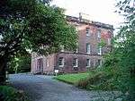 | |||
| Dalton Village, School, Playground Walls and Gatepiers | 55°03′09″N 3°22′47″W | Category C(S) | 3467 | | |||
| Dormont Grange House | 55°03′38″N 3°23′32″W | Category C(S) | 3474 | | |||
| Dalton Village, Dalton Parish Church | 55°03′09″N 3°23′19″W | Category B | 3458 | .jpg) | |||
| Dalton Village, Old Schoolhouse | 55°03′07″N 3°23′06″W | Category C(S) | 3457 | 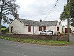 | |||
| Dalton Village, Finial from Old Parish Church | 55°03′09″N 3°23′17″W | Category B | 3459 | | |||
| Dormont, West Lodge and Gatepiers | 55°03′42″N 3°23′46″W | Category B | 3460 | | |||
| Dalton Village, Rose Cottage | 55°03′09″N 3°23′08″W | Category C(S) | 3466 | | |||
| Denbie House | 55°02′35″N 3°23′34″W | Category A | 3469 | | |||
| Denbie, Dovecot | 55°02′39″N 3°23′46″W | Category A | 3470 | | |||
| Denbie, Former Stables and Kennels | 55°02′35″N 3°23′44″W | Category B | 3472 | | |||
| Kirkwood, West Lodge and Gatepiers | 55°03′48″N 3°23′07″W | Category C(S) | 3374 | | |||
| Flosh Bridge | 55°03′46″N 3°23′53″W | Category C(S) | 3462 | | |||
| Kirkwood House | 55°03′49″N 3°22′37″W | Category B | 3465 | | |||
| Denbie, Walled Garden | 55°02′34″N 3°23′35″W | Category B | 3471 | | |||
| Rammerscales, Wellhead | 55°05′04″N 3°26′26″W | Category B | 3794 | | |||
| Williamwath Bridge over River Annan | 55°04′17″N 3°23′03″W | Category B | 3797 | .jpg) | |||
| Denbie, Lodge and Gatepiers | 55°02′41″N 3°24′03″W | Category C(S) | 3473 | |
Key
The scheme for classifying buildings in Scotland is:
- Category A: "buildings of national or international importance, either architectural or historic; or fine, little-altered examples of some particular period, style or building type."[1]
- Category B: "buildings of regional or more than local importance; or major examples of some particular period, style or building type, which may have been altered."[1]
- Category C: "buildings of local importance; lesser examples of any period, style, or building type, as originally constructed or moderately altered; and simple traditional buildings which group well with other listed buildings."[1]
In March 2016 there were 47,288 listed buildings in Scotland. Of these, 8 per cent were Category A, and 50 per cent were Category B, with the rest listed at Category C.[2]
Notes
- Sometimes known as OSGB36, the grid reference (where provided) is based on the British national grid reference system used by the Ordnance Survey.
• "Guide to National Grid". Ordnance Survey. Retrieved 2007-12-12.
• "Get-a-map". Ordnance Survey. Retrieved 2007-12-17. - Historic Environment Scotland assign a unique alphanumeric identifier to each designated site in Scotland, for listed buildings this always begins with "LB", for example "LB12345".
References
- All entries, addresses and coordinates are based on data from Historic Scotland. This data falls under the Open Government Licence
- "What is Listing?". Historic Environment Scotland. Retrieved 29 May 2018.
- Scotland's Historic Environment Audit 2016 (PDF). Historic Environment Scotland and the Built Environment Forum Scotland. pp. 15–16. Retrieved 29 May 2018.
This article is issued from Wikipedia. The text is licensed under Creative Commons - Attribution - Sharealike. Additional terms may apply for the media files.