List of listed buildings in Lochmaben, Dumfries and Galloway
This is a list of listed buildings in the civil parish of Lochmaben in Dumfries and Galloway, Scotland.
List
| Name | Location | Date Listed | Grid Ref. [note 1] | Geo-coordinates | Notes | LB Number [note 2] | Image |
|---|---|---|---|---|---|---|---|
| Castle Street, Bruce Arms | 55°07′43″N 3°26′31″W | Category B | 37538 | 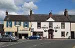 | |||
| High Street, Lochmaben Parish Church Boundary Wall and Gatepiers (St Magdalene's) | 55°07′35″N 3°26′19″W | Category A | 37539 | 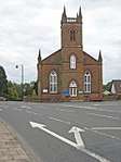 | |||
| 61 (Castle Grove), 63, 65 High Street (also known as 1, 2, 3 Church Place) | 55°07′36″N 3°26′21″W | Category B | 37548 |  | |||
| 34 High Street, The Old Schoolhouse | 55°07′41″N 3°26′24″W | Category B | 37553 | | |||
| Corncockle Farmhouse | 55°09′57″N 3°26′27″W | Category B | 9968 | | |||
| 5, 7 High Street | 55°07′44″N 3°26′31″W | Category B | 37542 | | |||
| 4 High Street | 55°07′45″N 3°26′30″W | Category B | 37549 | | |||
| 6 High Street, Balcarres | 55°07′45″N 3°26′28″W | Category B | 37550 | | |||
| Halleaths Lodge at Stables | 55°07′35″N 3°25′05″W | Category C(S) | 9972 | | |||
| Kinnel Bridge | 55°09′04″N 3°25′50″W | Category A | 9950 | 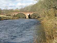 | |||
| Lochmaben Market Cross | 55°07′44″N 3°26′37″W | Category B | 37554 | 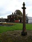 | |||
| St Mary Magdalene's Churchyard | 55°07′42″N 3°26′33″W | Category B | 37555 | | |||
| 9 Bruce Street including Oliver's Shop | 55°07′45″N 3°25′49″W | Category B | 37533 | | |||
| Woodfoot Farmhouse | 55°05′04″N 3°25′45″W | Category C(S) | 9967 | | |||
| Elshieshields Tower and adjoining House, Walled Garden and Gatepiers at South | 55°09′03″N 3°27′47″W | Category A | 9970 | | |||
| 41 High Street | 55°07′40″N 3°26′26″W | Category C(S) | 37546 | | |||
| High Street, Victoria House (Former Free Church Manse) | 55°07′37″N 3°26′24″W | Category C(S) | 37547 | | |||
| Heck Village Lake House and detached Outbuilding | 55°06′28″N 3°25′11″W | Category C(S) | 9948 | | |||
| High Street, Tolbooth including Iron Lamps | 55°07′44″N 3°26′30″W | Category A | 37541 | | |||
| 17, 19 High Street | 55°07′43″N 3°26′29″W | Category C(S) | 37544 | | |||
| 21 High Street, Royal Bank Of Scotland | 55°07′43″N 3°26′29″W | Category C(S) | 37545 | | |||
| 12 (Kismet), 14 Bruce Street | 55°07′43″N 3°26′37″W | Category B | 37536 | | |||
| Bruce Street, Old Bank House | 55°07′43″N 3°26′38″W | Category B | 37537 | | |||
| Halleaths Home Farm, House and Steading | 55°07′38″N 3°25′08″W | Category B | 9944 | | |||
| Heck Village, Heck Hill Farm Steading Row to Roadside including Cottages | 55°06′27″N 3°25′07″W | Category C(S) | 9947 | | |||
| Kinnel Bridge, Todhillmuir Cottage | 55°09′05″N 3°25′49″W | Category C(S) | 9951 | .jpg) | |||
| Shaw Bridge | 55°09′46″N 3°26′52″W | Category B | 9956 | | |||
| Mayfield House and Outbuildings | 55°07′38″N 3°25′53″W | Category C(S) | 9953 | | |||
| 10 High Street, Dalveen | 55°07′44″N 3°26′28″W | Category C(S) | 37551 | | |||
| 6 Bruce Street. Former Manse and Walled Garden | 55°07′44″N 3°26′35″W | Category B | 37534 | | |||
| 8 Bruce Street, Crown Hotel | 55°07′43″N 3°26′36″W | Category C(S) | 37535 | | |||
| Spedlins Tower | 55°10′26″N 3°25′06″W | Category A | 9965 | .jpg) | |||
| Elshieshields Bridge | 55°09′09″N 3°27′50″W | Category B | 9969 |  | |||
| Millhouse Bridge Village, Millhouse Bridge | 55°09′21″N 3°24′24″W | Category A | 9954 | | |||
| Moss-Side Cottages | 55°07′09″N 3°25′02″W | Category C(S) | 9955 | | |||
| High Street, Statue of Robert Bruce | 55°07′44″N 3°26′29″W | Category B | 37540 |  | |||
| 15 High Street, Kings Arms Hotel | 55°07′43″N 3°26′29″W | Category C(S) | 37543 | .jpg) | |||
| 14 High Street, Library and Freemason's Hall | 55°07′44″N 3°26′28″W | Category C(S) | 37552 | | |||
| Vendaceburn | 55°07′03″N 3°26′24″W | Category B | 9966 | | |||
| Halleaths former Stables (Houses and SSEB Stores and Workshops) | 55°07′37″N 3°25′02″W | Category A | 9971 | | |||
| Halleaths, Lodge at Innerfield | 55°07′26″N 3°25′09″W | Category B | 9973 | |
Key
The scheme for classifying buildings in Scotland is:
- Category A: "buildings of national or international importance, either architectural or historic; or fine, little-altered examples of some particular period, style or building type."[1]
- Category B: "buildings of regional or more than local importance; or major examples of some particular period, style or building type, which may have been altered."[1]
- Category C: "buildings of local importance; lesser examples of any period, style, or building type, as originally constructed or moderately altered; and simple traditional buildings which group well with other listed buildings."[1]
In March 2016 there were 47,288 listed buildings in Scotland. Of these, 8 per cent were Category A, and 50 per cent were Category B, with the rest listed at Category C.[2]
Notes
- Sometimes known as OSGB36, the grid reference (where provided) is based on the British national grid reference system used by the Ordnance Survey.
• "Guide to National Grid". Ordnance Survey. Retrieved 12 December 2007.
• "Get-a-map". Ordnance Survey. Retrieved 17 December 2007. - Historic Environment Scotland assign a unique alphanumeric identifier to each designated site in Scotland, for listed buildings this always begins with "LB", for example "LB12345".
References
- All entries, addresses and coordinates are based on data from Historic Scotland. This data falls under the Open Government Licence
- "What is Listing?". Historic Environment Scotland. Retrieved 29 May 2018.
- Scotland's Historic Environment Audit 2016 (PDF). Historic Environment Scotland and the Built Environment Forum Scotland. pp. 15–16. Retrieved 29 May 2018.
| Wikimedia Commons has media related to Lochmaben. |
This article is issued from Wikipedia. The text is licensed under Creative Commons - Attribution - Sharealike. Additional terms may apply for the media files.