List of listed buildings in Moffat, Dumfries and Galloway
This is a list of listed buildings in the civil parish of Moffat in Dumfries and Galloway, Scotland.
List
| Name | Location | Date Listed | Grid Ref. [note 1] | Geo-coordinates | Notes | LB Number [note 2] | Image |
|---|---|---|---|---|---|---|---|
| 20 Well Road Strathview (North Side) | 55°20′01″N 3°26′24″W | Category B | 37943 |  | |||
| Well Road Floral Cottage And Briary Cottage (North Side) | 55°20′05″N 3°26′14″W | Category B | 37946 | | |||
| 11-13 (Odd) Well Street | 55°19′59″N 3°26′35″W | Category C(S) | 37950 | | |||
| 27, 29 Well Street | 55°19′59″N 3°26′33″W | Category C(S) | 37953 | | |||
| Academy Road, St Mary's Uf Church | 55°20′07″N 3°26′42″W | Category B | 37857 | | |||
| Academy Road, Stratford House | 55°20′05″N 3°26′43″W | Category C(S) | 37858 | | |||
| 5 Beechgrove | 55°20′12″N 3°26′48″W | Category C(S) | 37866 | | |||
| Born Side, St John's Episcopal Church | 55°19′57″N 3°26′28″W | Category B | 37879 | | |||
| High Street Raven's Neuk | 55°20′03″N 3°26′43″W | Category C(S) | 37903 | | |||
| High Street, Ram Lodge And Centra | 55°20′01″N 3°26′39″W | Category C(S) | 37907 | | |||
| High Street Bonnington Hotel | 55°19′59″N 3°26′38″W | Category B | 37911 | | |||
| High Street Old Court House | 55°19′58″N 3°26′37″W | Category B | 37912 | | |||
| High Street, Old Parish Churchyard | 55°19′56″N 3°26′33″W | Category C(S) | 37917 | | |||
| 4 High Street The Coachman | 55°19′59″N 3°26′40″W | Category B | 37921 | | |||
| Victoria Place Larch-Hill House | 55°20′08″N 3°26′33″W | Category B | 37937 | | |||
| Well Road, Mill Cottage (South Side) | 55°20′01″N 3°26′17″W | Category C(S) | 37939 | | |||
| Breckonside Tower | 55°18′21″N 3°24′24″W | Category C(S) | 16848 | | |||
| Granton House, Balustrade To South And Gatepiers | 55°22′28″N 3°27′43″W | Category A | 16858 | | |||
| Holehouse Linn Bridge | 55°21′48″N 3°28′41″W | Category B | 16860 | | |||
| Ballplay Road Wellview | 55°20′00″N 3°25′54″W | Category C(S) | 37862 | | |||
| 7 Beechgrove Roseneath | 55°20′13″N 3°26′48″W | Category C(S) | 37868 | | |||
| 9 And 10 (Hillview) Beechgrove | 55°20′14″N 3°26′49″W | Category C(S) | 37870 | | |||
| 14 Beechgrove Rockhill | 55°20′15″N 3°26′51″W | Category C(S) | 37874 | | |||
| 17 Beechgrove Springfield | 55°20′16″N 3°26′52″W | Category C(S) | 37876 | | |||
| Church View, Church Gate | 55°19′55″N 3°26′38″W | Category C(S) | 37885 | | |||
| 7 Church Street | 55°19′58″N 3°26′41″W | Category C(S) | 37888 | | |||
| Eastgate, Limetree House | 55°20′01″N 3°26′35″W | Category B | 37889 | | |||
| High Street Balmoral Hotel (Former Spur Inn) | 55°20′00″N 3°26′39″W | Category B | 37909 | | |||
| High Street Buccleuch Arms | 55°19′57″N 3°26′40″W | Category B | 37922 | | |||
| High Street Annandale Arms Hotel | 55°19′59″N 3°26′41″W | Category B | 37926 | | |||
| Mansfield Place, Proudfoot Institute | 55°19′58″N 3°26′32″W | Category B | 37929 | | |||
| Old Well Road Park Cottage | 55°20′05″N 3°26′29″W | Category B | 37931 | | |||
| School Lane Kirkland House | 55°20′02″N 3°26′27″W | Category B | 37933 | | |||
| Dumcrieff Bridge | 55°18′57″N 3°25′12″W | Category C(S) | 16855 | | |||
| Heatheryhaugh, Garden Bridge | 55°20′30″N 3°25′56″W | Category B | 16862 | | |||
| New Bridge (Formerly A701 Over River Annan) | 55°20′13″N 3°27′11″W | Category C(S) | 16866 | | |||
| Well Road Millbank (North Side) | 55°20′06″N 3°26′06″W | Category C(S) | 37947 | | |||
| Academy Road, 1 Stanley Place, Kirkview And Archbald Moffatt House (Formerly 2 Stanley Place) | 55°20′07″N 3°26′45″W | Category B | 37861 | | |||
| Ballplay Road Dunmore Villa | 55°19′59″N 3°25′53″W | Category B | 37863 | | |||
| Eastgate Summerlea House | 55°20′03″N 3°26′39″W | Category C(S) | 37891 | | |||
| Eastgate St Ninian's Prep School | 55°20′03″N 3°26′32″W | Category C(S) | 37894 | | |||
| Glendyne Hartfell Crescent | 55°20′12″N 3°26′23″W | Category B | 37897 | | |||
| Haywood Road Hunter's Croft | 55°20′08″N 3°26′04″W | Category C(S) | 37898 | | |||
| Haywood Road, Merlewood | 55°20′12″N 3°26′08″W | Category B | 37899 | | |||
| High Street Ivy House | 55°20′02″N 3°26′40″W | Category C(S) | 37905 | | |||
| High Street, Moffat Post Office | 55°20′01″N 3°26′39″W | Category C(S) | 37908 | | |||
| High Street, Spar With 1-5 Well Street | 55°19′58″N 3°26′37″W | Category B | 37913 | | |||
| High Street, The Tartan Gift Shop And 2 Holm Street | 55°19′56″N 3°26′37″W | Category C(S) | 37918 | | |||
| Archbank Bridge | 55°20′48″N 3°25′57″W | Category B | 16846 | | |||
| Archbank Farm, Tall Barn With Waterwheel | 55°20′48″N 3°26′06″W | Category A | 16847 | | |||
| Meikleholmside Bridge | 55°21′50″N 3°27′54″W | Category C(S) | 16864 | | |||
| Academy Road, Seamore House | 55°20′05″N 3°26′44″W | Category C(S) | 37860 | | |||
| Ballplay Road, Holm Park, Former St Kiernan's School And Gatepiers | 55°19′56″N 3°25′55″W | Category B | 37864 | | |||
| 3 And 4 Beechgrove | 55°20′12″N 3°26′47″W | Category C(S) | 37865 | | |||
| 12 Beechgrove | 55°20′14″N 3°26′50″W | Category C(S) | 37872 | | |||
| 18 Beechgrove | 55°20′16″N 3°26′52″W | Category C(S) | 37877 | | |||
| 20 Beechgrove | 55°20′17″N 3°26′53″W | Category B | 37878 | | |||
| Eastgate, Limetree Cottage | 55°20′02″N 3°26′37″W | Category C(S) | 37890 | | |||
| Eastgate Victoria And Upper Victoria House And Victoria Place | 55°20′04″N 3°26′40″W | Category C(S) | 37892 | | |||
| High Street Ram Fountain | 55°20′01″N 3°26′41″W | Category B | 37902 | | |||
| 6 High Street R Little's Premises | 55°19′58″N 3°26′39″W | Category B | 37924 | | |||
| School Lane Southview | 55°20′03″N 3°26′25″W | Category B | 37934 | | |||
| Heatheryhaugh | 55°20′31″N 3°25′57″W | Category A | 16861 | | |||
| Well Road, Oak Tree Cottage, Rose Cottage (North Side) | 55°20′02″N 3°26′19″W | Category C(S) | 37945 | | |||
| 7 And 9 Well Street (7 Trustee Savings Bank) | 55°19′58″N 3°26′36″W | Category C(S) | 37949 | | |||
| 8 Beechgrove Holmbury | 55°20′13″N 3°26′49″W | Category C(S) | 37869 | | |||
| Mrs Crichton's House, Chapel Street | 55°19′59″N 3°26′33″W | Category B | 37880 | | |||
| Churchgate Black Bull Hotel | 55°19′54″N 3°26′38″W | Category B | 37883 | | |||
| 5 Church Street | 55°19′58″N 3°26′41″W | Category C(S) | 37887 | | |||
| High Street Moffat Weavers Tweed Shop | 55°20′00″N 3°26′38″W | Category C(S) | 37910 | | |||
| High Street Forestry Commission Premises | 55°19′57″N 3°26′36″W | Category C(S) | 37916 | | |||
| 1-3 (Consec) High Street | 55°19′56″N 3°26′39″W | Category C(S) | 37920 | | |||
| High Street Town Hall And Police Station | 55°20′00″N 3°26′42″W | Category B | 37927 | | |||
| Craigieburn, Stables | 55°20′05″N 3°23′38″W | Category C(S) | 16852 | | |||
| Corehead Farm, Bught (Sheep Fank) At Devil's Beeftub | 55°24′03″N 3°28′49″W | Category B | 16854 | | |||
| Heatheryhaugh, Former Stables And Gatepiers | 55°20′32″N 3°25′57″W | Category B | 16863 | | |||
| Academy Road, Moffat Academy | 55°20′10″N 3°26′44″W | Category C(S) | 50153 | | |||
| Station Park, Timber Pavilion | 55°19′46″N 3°26′41″W | Category C(S) | 51589 | | |||
| Well Road, Southfield (North Side) | 55°20′01″N 3°26′23″W | Category C(S) | 37944 | | |||
| 15, 17 Well Street, The Duka | 55°19′59″N 3°26′34″W | Category B | 37951 | | |||
| Academy Road, Hopetoun House | 55°20′06″N 3°26′45″W | Category B | 37859 | | |||
| 6 Beechgrove Del Mar | 55°20′13″N 3°26′48″W | Category C(S) | 37867 | | |||
| 11 Beechgrove | 55°20′14″N 3°26′50″W | Category C(S) | 37871 | | |||
| Hartfell Crescent Claremont And Westwood | 55°20′11″N 3°26′27″W | Category B | 37895 | | |||
| Hartfell House Hartfell Crescent | 55°20′12″N 3°26′25″W | Category B | 37896 | | |||
| 5 High Street Moffat Sports Centre | 55°19′57″N 3°26′39″W | Category C(S) | 37923 | | |||
| High Street Moffat House Hotel | 55°20′02″N 3°26′46″W | Category A | 37928 | 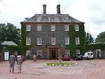 | |||
| Sidmount Avenue Sidmount Cottage | 55°20′08″N 3°26′12″W | Category A | 37935 | | |||
| Well Road, Lauchope Lodge | 55°20′12″N 3°26′03″W | Category C(S) | 37948 | | |||
| 25 Well Street | 55°19′59″N 3°26′34″W | Category B | 37952 | | |||
| 13 Beechgrove Buchan House | 55°20′15″N 3°26′50″W | Category B | 37873 | | |||
| Church Gate St Andrew's Parish Church Manse | 55°19′53″N 3°26′42″W | Category B | 37882 | | |||
| Church Gate Harthope House | 55°19′55″N 3°26′38″W | Category B | 37884 | | |||
| 3 Church Street | 55°19′58″N 3°26′41″W | Category B | 37886 | | |||
| Eastgate Albert House | 55°20′05″N 3°26′42″W | Category C(S) | 37893 | | |||
| Haywood Road Woodlands | 55°20′12″N 3°26′06″W | Category B | 37901 | | |||
| High Street Arden House | 55°20′03″N 3°26′42″W | Category B | 37904 | | |||
| High Street 4 Bath Place | 55°20′02″N 3°26′40″W | Category B | 37906 | | |||
| Well Road, Burnock Lodge (East Side) | 55°20′18″N 3°26′00″W | Category B | 37941 | | |||
| 23 Well Road (North Side) | 55°20′00″N 3°26′26″W | Category C(S) | 37942 | | |||
| Craigieburn Hermitage | 55°20′02″N 3°23′48″W | Category C(S) | 16850 | | |||
| Crofthead Farmhouse And Steading | 55°20′01″N 3°23′03″W | Category C(S) | 16853 | | |||
| Dumcrieff House | 55°19′06″N 3°25′00″W | Category B | 16856 | | |||
| Moffat Well | 55°21′01″N 3°25′58″W | Category B | 16865 | | |||
| 16 Beechgrove | 55°20′16″N 3°26′52″W | Category C(S) | 37875 | | |||
| Churchgate St Andrew's Parish Church | 55°19′54″N 3°26′41″W | Category A | 37881 | 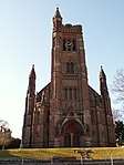 | |||
| Haywood Road North Park | 55°20′14″N 3°26′04″W | Category B | 37900 | | |||
| High Street Star Hotel | 55°19′58″N 3°26′37″W | Category C(S) | 37914 | | |||
| High Street J Hyslop And Co Premises | 55°19′57″N 3°26′37″W | Category B | 37915 | | |||
| High Street, Bank Of Scotland | 55°19′56″N 3°26′38″W | Category C(S) | 37919 | | |||
| 9 High Street, Gemini Jewellers | 55°19′58″N 3°26′40″W | Category C(S) | 37925 | | |||
| Old Well Road, Alma And 1 Well Road | 55°20′01″N 3°26′31″W | Category C(S) | 37930 | | |||
| Old Well Road Davington House | 55°20′05″N 3°26′29″W | Category C(S) | 37932 | | |||
| Star Street Range Of Cottages To Rear Of Star Inn | 55°19′58″N 3°26′35″W | Category C(S) | 37936 | | |||
| 2 Well Road Park House (South Side) | 55°20′00″N 3°26′31″W | Category B | 37938 | | |||
| Well Road Burnside (South Side) | 55°20′05″N 3°26′03″W | Category B | 37940 | | |||
| Craigieburn House | 55°20′06″N 3°23′43″W | Category B | 16849 | | |||
| Craigieburn, Lodge And Gatepiers | 55°19′59″N 3°23′40″W | Category C(S) | 16851 | |
Key
The scheme for classifying buildings in Scotland is:
- Category A: "buildings of national or international importance, either architectural or historic; or fine, little-altered examples of some particular period, style or building type."[1]
- Category B: "buildings of regional or more than local importance; or major examples of some particular period, style or building type, which may have been altered."[1]
- Category C: "buildings of local importance; lesser examples of any period, style, or building type, as originally constructed or moderately altered; and simple traditional buildings which group well with other listed buildings."[1]
In March 2016 there were 47,288 listed buildings in Scotland. Of these, 8 per cent were Category A, and 50 per cent were Category B, with the rest listed at Category C.[2]
Notes
- Sometimes known as OSGB36, the grid reference (where provided) is based on the British national grid reference system used by the Ordnance Survey.
• "Guide to National Grid". Ordnance Survey. Retrieved 2007-12-12.
• "Get-a-map". Ordnance Survey. Retrieved 2007-12-17. - Historic Environment Scotland assign a unique alphanumeric identifier to each designated site in Scotland, for listed buildings this always begins with "LB", for example "LB12345".
References
- All entries, addresses and coordinates are based on data from Historic Scotland. This data falls under the Open Government Licence
- "What is Listing?". Historic Environment Scotland. Retrieved 29 May 2018.
- Scotland's Historic Environment Audit 2016 (PDF). Historic Environment Scotland and the Built Environment Forum Scotland. pp. 15–16. Retrieved 29 May 2018.
| Wikimedia Commons has media related to Moffat. |
This article is issued from Wikipedia. The text is licensed under Creative Commons - Attribution - Sharealike. Additional terms may apply for the media files.