List of listed buildings in Kirkpatrick Irongray, Dumfries and Galloway
List
| Name | Location | Date Listed | Grid Ref. [note 1] | Geo-coordinates | Notes | LB Number [note 2] | Image |
|---|---|---|---|---|---|---|---|
| West Cluden Farmhouse | 55°05′51″N 3°39′54″W | Category C(S) | 10348 |  | |||
| Kirkpatrick Irongray Parish Manse, Outbuildings And Gatepiers | 55°05′50″N 3°42′10″W | Category C(S) | 10349 | | |||
| Hallhill Bridge (Over Cluden Water) | 55°06′06″N 3°42′53″W | Category C(S) | 10360 | | |||
| High Grove Cottage | 55°05′14″N 3°42′13″W | Category C(S) | 10361 | | |||
| Cornlee Bridge (Over Old Water) | 55°05′23″N 3°49′26″W | Category C(S) | 10355 | | |||
| Rosebank Bridge (Over Old Water) | 55°04′08″N 3°45′53″W | Category C(S) | 10350 | | |||
| Routin Bridge | 55°05′58″N 3°44′49″W | Category B | 10351 | 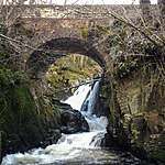 | |||
| Bonerick House | 55°04′19″N 3°42′56″W | Category C(S) | 10354 | | |||
| Glenkiln Former Lodge To Mollance House | 55°04′45″N 3°48′19″W | Category B | 10358 | | |||
| Irongray Bridge (Over Cluden Water) | 55°05′57″N 3°41′56″W | Category B | 10362 | | |||
| West Cluden Cottage To North West Of Former Mill | 55°05′50″N 3°39′46″W | Category C(S) | 10347 | | |||
| Drumpark East Lodge, Quadrant Walls And Gatepiers | 55°06′09″N 3°45′50″W | Category B | 10356 | | |||
| Drumpark West Lodge | 55°06′10″N 3°45′57″W | Category B | 10357 | | |||
| The Grove, House And Gatepiers | 55°05′05″N 3°41′47″W | Category B | 10359 | | |||
| Skeoch Hill Monument | 55°05′34″N 3°47′21″W | Category B | 10352 | | |||
| West Cluden Former Corn Mill | 55°05′51″N 3°39′46″W | Category C(S) | 10346 | | |||
| Kirkpatrick Irongray Martyrs' Monument | 55°05′59″N 3°42′36″W | Category B | 10363 | | |||
| Kirkpatrick Irongray Parish Church And Churchyard | 55°05′55″N 3°42′06″W | Category B | 10364 | 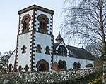 |
Key
The scheme for classifying buildings in Scotland is:
- Category A: "buildings of national or international importance, either architectural or historic; or fine, little-altered examples of some particular period, style or building type."[1]
- Category B: "buildings of regional or more than local importance; or major examples of some particular period, style or building type, which may have been altered."[1]
- Category C: "buildings of local importance; lesser examples of any period, style, or building type, as originally constructed or moderately altered; and simple traditional buildings which group well with other listed buildings."[1]
In March 2016 there were 47,288 listed buildings in Scotland. Of these, 8 per cent were Category A, and 50 per cent were Category B, with the rest listed at Category C.[2]
Notes
- Sometimes known as OSGB36, the grid reference (where provided) is based on the British national grid reference system used by the Ordnance Survey.
• "Guide to National Grid". Ordnance Survey. Retrieved 2007-12-12.
• "Get-a-map". Ordnance Survey. Retrieved 2007-12-17. - Historic Environment Scotland assign a unique alphanumeric identifier to each designated site in Scotland, for listed buildings this always begins with "LB", for example "LB12345".
References
- All entries, addresses and coordinates are based on data from Historic Scotland. This data falls under the Open Government Licence
- "What is Listing?". Historic Environment Scotland. Retrieved 29 May 2018.
- Scotland's Historic Environment Audit 2016 (PDF). Historic Environment Scotland and the Built Environment Forum Scotland. pp. 15–16. Retrieved 29 May 2018.
| Wikimedia Commons has media related to Irongray. |
This article is issued from Wikipedia. The text is licensed under Creative Commons - Attribution - Sharealike. Additional terms may apply for the media files.