List of listed buildings in Buittle, Dumfries and Galloway
List
| Name | Location | Date Listed | Grid Ref. [note 1] | Geo-coordinates | Notes | LB Number [note 2] | Image |
|---|---|---|---|---|---|---|---|
| Buittle Parish Church, (Church Of Scotland) And Walled Churchyard | 54°55′10″N 3°51′41″W | Category B | 3366 |  | |||
| Palnackie 1-4 Cannon Place (Inclusive Nos) | 54°53′31″N 3°50′30″W | Category C(S) | 3388 | | |||
| Old Orchardton Farmhouse And Steadings To East | 54°52′38″N 3°50′46″W | Category B | 3369 | | |||
| Palnackie, 6-14 (Even Nos) Port Street | 54°53′32″N 3°50′24″W | Category C(S) | 3371 | | |||
| Palnackie, 1, 3 (Odd Nos) Port Street | 54°53′33″N 3°50′26″W | Category C(S) | 3389 | | |||
| Buittle Old Church | 54°55′08″N 3°51′42″W | Category A | 3365 | 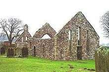 | |||
| Buittle Bridge, Dalbeattie (Also Known As Craignair Bridge) | 54°55′36″N 3°50′20″W | Category A | 3364 | 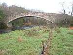 | |||
| Halketleaths Farm | 54°57′11″N 3°52′42″W | Category B | 3368 | | |||
| Palnackie, 16 Port Street (Bow House) | 54°53′33″N 3°50′23″W | Category B | 3372 | | |||
| Buittle Place | 54°56′08″N 3°50′46″W | Category B | 3367 | | |||
| Palnackie, 2-4 (Even Nos) Port Street | 54°53′32″N 3°50′26″W | Category B | 3370 | | |||
| Orchardton Tower | 54°52′37″N 3°50′43″W | Category A | 3387 | 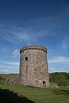 |
Key
The scheme for classifying buildings in Scotland is:
- Category A: "buildings of national or international importance, either architectural or historic; or fine, little-altered examples of some particular period, style or building type."[1]
- Category B: "buildings of regional or more than local importance; or major examples of some particular period, style or building type, which may have been altered."[1]
- Category C: "buildings of local importance; lesser examples of any period, style, or building type, as originally constructed or moderately altered; and simple traditional buildings which group well with other listed buildings."[1]
In March 2016 there were 47,288 listed buildings in Scotland. Of these, 8 per cent were Category A, and 50 per cent were Category B, with the rest listed at Category C.[2]
Notes
- Sometimes known as OSGB36, the grid reference (where provided) is based on the British national grid reference system used by the Ordnance Survey.
• "Guide to National Grid". Ordnance Survey. Retrieved 2007-12-12.
• "Get-a-map". Ordnance Survey. Retrieved 2007-12-17. - Historic Environment Scotland assign a unique alphanumeric identifier to each designated site in Scotland, for listed buildings this always begins with "LB", for example "LB12345".
References
- All entries, addresses and coordinates are based on data from Historic Scotland. This data falls under the Open Government Licence
- "What is Listing?". Historic Environment Scotland. Retrieved 29 May 2018.
- Scotland's Historic Environment Audit 2016 (PDF). Historic Environment Scotland and the Built Environment Forum Scotland. pp. 15–16. Retrieved 29 May 2018.
| Wikimedia Commons has media related to Buittle. |
This article is issued from Wikipedia. The text is licensed under Creative Commons - Attribution - Sharealike. Additional terms may apply for the media files.