List of listed buildings in Westerkirk, Dumfries and Galloway
This is a list of listed buildings in the civil parish of Westerkirk in Dumfries and Galloway, Scotland.
List
| Name | Location | Date Listed | Grid Ref. [note 1] | Geo-coordinates | Notes | LB Number [note 2] | Image |
|---|---|---|---|---|---|---|---|
| Craig Farmhouse | 55°11′09″N 3°02′11″W | Category C(S) | 16927 |  | |||
| Hopsrig Farmhouse and Steading | 55°11′15″N 3°03′54″W | Category B | 16933 | | |||
| Westerhall Farm (former Stables) | 55°11′27″N 3°03′45″W | Category B | 16937 | | |||
| Bentpath Village, Westerkirk Old Churchyard, Johnstone Mausoleum | 55°12′09″N 3°04′52″W | Category A | 16921 | 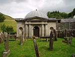 | |||
| Westerhall House | 55°11′35″N 3°04′14″W | Category B | 16936 | .jpg) | |||
| Bentpath Village, Westerkirk Library | 55°12′00″N 3°05′16″W | Category B | 16940 | | |||
| Burnfoot House with former Stable | 55°11′19″N 3°02′40″W | Category B | 49631 | | |||
| Bentpath Village, Westerkirk Parish Church, retaining Wall And Gatepiers | 55°12′08″N 3°04′58″W | Category B | 16919 | .jpg) | |||
| Bentpath Village, Westerkirk School and Schoolhouse | 55°12′01″N 3°05′15″W | Category C(S) | 16922 | | |||
| Black Esk Bridge (Minor Road Over Black Esk) | 55°12′19″N 3°10′36″W | Category C(S) | 16924 | | |||
| Craigcleuch House, North Lodge and Gatepiers | 55°10′19″N 3°01′59″W | Category C(S) | 16929 | | |||
| Enzieholm Farmhouse | 55°12′43″N 3°07′09″W | Category C(S) | 16932 | | |||
| Bentpath Village, The White House, Garden Wall and Gatepiers | 55°12′10″N 3°04′56″W | Category B | 16923 | | |||
| Bentpath Village, Westerkirk Old Churchyard | 55°12′08″N 3°04′58″W | Category B | 16920 | | |||
| Enzieholm Bridge (B709 over River Esk) | 55°12′41″N 3°07′28″W | Category B | 16931 | | |||
| Westerhall, Bridge over Kirk Burn (Near Bentpath) | 55°12′10″N 3°04′48″W | Category C(S) | 16935 | | |||
| Burnfoot Bridge | 55°11′22″N 3°02′32″W | Category C(S) | 16925 | | |||
| Stennieswaterfoot | 55°13′25″N 3°06′28″W | Category B | 16934 | | |||
| Burnfoot Farmhouse and Steading | 55°11′28″N 3°02′53″W | Category B | 16926 | | |||
| Bentpath Village, Bentpath Bridge (Over River Esk) | 55°12′06″N 3°04′59″W | Category A | 16939 | 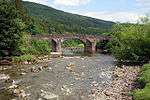 | |||
| Bentpath Village, Telford Monument at Westerkirk Library | 55°11′59″N 3°05′14″W | Category C(S) | 16918 | 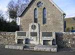 | |||
| Craigcleuch House | 55°10′17″N 3°01′53″W | Category B | 16928 | | |||
| Drove Knowe Monument to Sir F G Johnstone Of Westerhall | 55°11′56″N 3°04′57″W | Category B | 16930 | | |||
| Westerhall House, North Lodge and Gatepiers | 55°12′08″N 3°04′45″W | Category C(S) | 16938 | | |||
| Bentpath Village, Esk Cottage | 55°12′05″N 3°05′00″W | Category C(S) | 13907 | |
Key
The scheme for classifying buildings in Scotland is:
- Category A: "buildings of national or international importance, either architectural or historic; or fine, little-altered examples of some particular period, style or building type."[1]
- Category B: "buildings of regional or more than local importance; or major examples of some particular period, style or building type, which may have been altered."[1]
- Category C: "buildings of local importance; lesser examples of any period, style, or building type, as originally constructed or moderately altered; and simple traditional buildings which group well with other listed buildings."[1]
In March 2016 there were 47,288 listed buildings in Scotland. Of these, 8 per cent were Category A, and 50 per cent were Category B, with the rest listed at Category C.[2]
Notes
- Sometimes known as OSGB36, the grid reference (where provided) is based on the British national grid reference system used by the Ordnance Survey.
• "Guide to National Grid". Ordnance Survey. Retrieved 2007-12-12.
• "Get-a-map". Ordnance Survey. Retrieved 2007-12-17. - Historic Environment Scotland assign a unique alphanumeric identifier to each designated site in Scotland, for listed buildings this always begins with "LB", for example "LB12345".
References
- All entries, addresses and coordinates are based on data from Historic Scotland. This data falls under the Open Government Licence
- "What is Listing?". Historic Environment Scotland. Retrieved 29 May 2018.
- Scotland's Historic Environment Audit 2016 (PDF). Historic Environment Scotland and the Built Environment Forum Scotland. pp. 15–16. Retrieved 29 May 2018.
This article is issued from Wikipedia. The text is licensed under Creative Commons - Attribution - Sharealike. Additional terms may apply for the media files.