List of listed buildings in Old Luce, Dumfries and Galloway
This is a list of listed buildings in the civil parish of Old Luce in Dumfries and Galloway, Scotland.
List
| Name | Location | Date Listed | Grid Ref. [note 1] | Geo-coordinates | Notes | LB Number [note 2] | Image |
|---|---|---|---|---|---|---|---|
| Glenluce, Ladyburn Masonic Temple, (Former Ladyburn Church), With Railings And Gates | 54°52′42″N 4°48′37″W | Category C(S) | 19324 |  | |||
| Glenluce, 17 Main Street | 54°52′42″N 4°48′42″W | Category B | 19327 | | |||
| Glenluce, 141 And 143 Main Street,Minn Cree And Woodbank, With Garden Walls | 54°52′54″N 4°48′12″W | Category C(S) | 19340 | | |||
| Glenluce, 62 And 64 Main Street, Fernlea And Roseneath | 54°52′47″N 4°48′32″W | Category C(S) | 19357 | | |||
| Glenluce, 72 Main Street | 54°52′49″N 4°48′30″W | Category C(S) | 19360 | | |||
| Grennan, Farmhouse, Steading, Sundial And Boundary Walls | 54°55′00″N 4°44′46″W | Category C(S) | 19366 | | |||
| North Milton, Farmhouse And Steading | 54°51′11″N 4°46′50″W | Category B | 19368 | | |||
| Drochduil School And Schoolhouse | 54°52′19″N 4°52′51″W | Category C(S) | 16764 | | |||
| Dunragit, The Kennels | 54°53′11″N 4°53′12″W | Category C(S) | 16767 | | |||
| Glenluce, 7 Church Street, Kirkton | 54°52′44″N 4°48′47″W | Category C(S) | 16791 | | |||
| Glenluce, 35-39 (Odd Nos) Main Street | 54°52′44″N 4°48′38″W | Category C(S) | 19332 | | |||
| Glenluce, 53 Main Street, Kelvin House Hotel | 54°52′46″N 4°48′36″W | Category C(S) | 19336 | | |||
| Glenluce, 16 And 18 Main Street | 54°52′42″N 4°48′41″W | Category C(S) | 19345 | | |||
| Glenluce, 76 Main Street | 54°52′49″N 4°48′28″W | Category B | 19361 | | |||
| Laigh Sinniness, Former Farmhouse And Steading | 54°50′06″N 4°46′39″W | Category C(S) | 19367 | | |||
| Glenluce, Ladyburn Manse | 54°52′52″N 4°48′07″W | Category C(S) | 19323 | | |||
| Glenluce, 61 Main Street | 54°52′47″N 4°48′35″W | Category C(S) | 19339 | | |||
| Glenluce, 161 And 163 Main Street, Beechgrove And Ravenswood, With Railings | 54°52′53″N 4°48′01″W | Category C(S) | 19341 | | |||
| Glenluce, 34 Main Street | 54°52′45″N 4°48′35″W | Category C(S) | 19352 | | |||
| Glenluce, 36 Main Street, Crown Hotel | 54°52′45″N 4°48′35″W | Category C(S) | 19353 | | |||
| Glenluce, 38 Main Street, Rowantree | 54°52′45″N 4°48′35″W | Category B | 19354 | | |||
| Glenluce, Millbank And Cottage | 54°52′51″N 4°47′50″W | Category B | 19362 | | |||
| Castle Of Park | 54°52′34″N 4°49′32″W | Category A | 16761 | | |||
| Craigenveoch | 54°52′03″N 4°44′49″W | Category C(S) | 16762 | | |||
| Auchenmalg, Auchenbrae, With Boundary Walls | 54°50′20″N 4°45′11″W | Category C(S) | 16781 | | |||
| Bridge Of Park | 54°52′41″N 4°49′14″W | Category B | 16784 | | |||
| Dunragit Home Farm, Sundial | 54°53′03″N 4°53′17″W | Category C(S) | 16785 | | |||
| Glenluce, 28A Main Street | 54°52′44″N 4°48′37″W | Category C(S) | 19349 | | |||
| Glenluce, War Memorial | 54°52′51″N 4°48′19″W | Category C(S) | 19365 | | |||
| Carscreugh Castle | 54°54′07″N 4°46′21″W | Category B | 16759 | | |||
| Carscreugh Castle, Cottages | 54°54′08″N 4°46′23″W | Category C(S) | 16760 | | |||
| Culroy, Farm Building | 54°51′00″N 4°43′22″W | Category B | 16763 | | |||
| Dunragit, East Lodge | 54°52′44″N 4°53′22″W | Category B | 16765 | | |||
| Bridge, Lady Burn | 54°52′22″N 4°48′56″W | Category C(S) | 16783 | | |||
| Genoch Doocot | 54°52′03″N 4°54′27″W | Category B | 16787 | | |||
| Glenluce, 31 Main Street, King's Arms Hotel | 54°52′44″N 4°48′40″W | Category C(S) | 19331 | | |||
| Glenluce, 47 Main Street, Ardville | 54°52′45″N 4°48′37″W | Category C(S) | 19335 | | |||
| Glenluce, 57 And 59 Main Street | 54°52′47″N 4°48′35″W | Category C(S) | 19338 | | |||
| Glenluce, 2 Main Street, With Railings | 54°52′40″N 4°48′45″W | Category C(S) | 19343 | | |||
| Glenluce, 20 Main Street | 54°52′42″N 4°48′40″W | Category C(S) | 19346 | | |||
| Glenluce, 30 Main Street, With Railings | 54°52′44″N 4°48′37″W | Category B | 19350 | | |||
| Glenluce, 32 Main Street | 54°52′44″N 4°48′36″W | Category C(S) | 19351 | | |||
| Glenluce, 52 And 54 Main Street | 54°52′46″N 4°48′34″W | Category C(S) | 19355 | | |||
| Glenluce, 1A Sun Street | 54°52′45″N 4°48′47″W | Category C(S) | 19364 | | |||
| Abbey House With Boundary Walls | 54°53′24″N 4°49′56″W | Category B | 16780 | | |||
| Gillespie, Farmhouse And Steading | 54°49′56″N 4°43′31″W | Category C(S) | 16789 | | |||
| Glenluce, 19 Main Street, Royal Bank Of Scotland | 54°52′42″N 4°48′42″W | Category B | 19328 | | |||
| Glenluce, 22 Main Street, Public Hall | 54°52′43″N 4°48′38″W | Category C(S) | 19347 | | |||
| Glenluce, North Street, Bridge | 54°52′53″N 4°48′29″W | Category C(S) | 19363 | | |||
| Old Luce Church, Graveyard, Graveyard Walls, Gatepiers And Gates | 54°52′44″N 4°48′43″W | Category B | 19369 | | |||
| Glenluce, Ladyburn Bridge | 54°52′40″N 4°48′39″W | Category C(S) | 19322 | | |||
| Glenluce, 43 And 45 Main Street | 54°52′45″N 4°48′37″W | Category B | 19334 | | |||
| Glenluce, 12 Main Street | 54°52′41″N 4°48′42″W | Category C(S) | 19344 | | |||
| Stair Haven, Store | 54°50′45″N 4°47′26″W | Category B | 19371 | | |||
| Dunragit, Signal Box | 54°52′39″N 4°53′16″W | Category C(S) | 16766 | 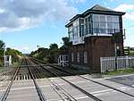 | |||
| Auchenmalg, Castle Daly Hotel, (Former School And Schoolhouse), With Boundary Walls | 54°50′21″N 4°45′09″W | Category B | 16782 | | |||
| Dunragit House | 54°53′03″N 4°53′10″W | Category B | 16786 | | |||
| Glenluce, Church Street, Bridge | 54°52′46″N 4°48′52″W | Category C(S) | 16790 | | |||
| Glenluce, 55 Main Street | 54°52′46″N 4°48′36″W | Category C(S) | 19337 | | |||
| Glenluce, 165 Main Street, Navarre, With Railings | 54°52′53″N 4°47′59″W | Category C(S) | 19342 | | |||
| Glenluce, 24 Main Street, Otterburn | 54°52′43″N 4°48′38″W | Category C(S) | 19348 | | |||
| Piltanton Bridge | 54°52′08″N 4°53′30″W | Category C(S) | 19370 | |
Key
The scheme for classifying buildings in Scotland is:
- Category A: "buildings of national or international importance, either architectural or historic; or fine, little-altered examples of some particular period, style or building type."[1]
- Category B: "buildings of regional or more than local importance; or major examples of some particular period, style or building type, which may have been altered."[1]
- Category C: "buildings of local importance; lesser examples of any period, style, or building type, as originally constructed or moderately altered; and simple traditional buildings which group well with other listed buildings."[1]
In March 2016 there were 47,288 listed buildings in Scotland. Of these, 8 per cent were Category A, and 50 per cent were Category B, with the rest listed at Category C.[2]
Notes
- Sometimes known as OSGB36, the grid reference (where provided) is based on the British national grid reference system used by the Ordnance Survey.
• "Guide to National Grid". Ordnance Survey. Retrieved 2007-12-12.
• "Get-a-map". Ordnance Survey. Retrieved 2007-12-17. - Historic Environment Scotland assign a unique alphanumeric identifier to each designated site in Scotland, for listed buildings this always begins with "LB", for example "LB12345".
References
- All entries, addresses and coordinates are based on data from Historic Scotland. This data falls under the Open Government Licence
- "What is Listing?". Historic Environment Scotland. Retrieved 29 May 2018.
- Scotland's Historic Environment Audit 2016 (PDF). Historic Environment Scotland and the Built Environment Forum Scotland. pp. 15–16. Retrieved 29 May 2018.
| Wikimedia Commons has media related to Old Luce. |
This article is issued from Wikipedia. The text is licensed under Creative Commons - Attribution - Sharealike. Additional terms may apply for the media files.