List of listed buildings in Glencairn, Dumfries and Galloway
This is a list of listed buildings in the parish of Glencairn in Dumfries and Galloway, Scotland.
| Wikimedia Commons has media related to Glencairn, Dumfries and Galloway. |
List
| Name | Location | Date Listed | Grid Ref. [note 1] | Geo-coordinates | Notes | LB Number [note 2] | Image |
|---|---|---|---|---|---|---|---|
| Crawfordton School East Lodge & Gatepiers | 55°11′38″N 3°53′11″W | Category B | 10344 |  | |||
| Kirkland Bridge Over Cairn Water | 55°11′27″N 3°52′02″W | Category B | 10310 |  | |||
| Kirkland Village Glencairn Parish Church | 55°11′39″N 3°52′21″W | Category A | 10312 | .jpg) | |||
| Kirkland Village Cottages | 55°11′38″N 3°52′20″W | Category B | 10322 | | |||
| Kirkland, Signpost At Junction Of A702 And B729 | 55°11′33″N 3°51′59″W | Category B | 50010 | | |||
| Maxwelton House Summerhouse To South West Of House | 55°11′13″N 3°51′10″W | Category B | 10328 | | |||
| Moniaive Village Broomfield House And Gatepiers | 55°11′57″N 3°55′46″W | Category B | 10332 | | |||
| Craigdarroch House Garden Building (To North Of House) | 55°11′48″N 3°58′45″W | Category B | 10341 | | |||
| Moniaive Village High Street George Hotel | 55°11′51″N 3°55′08″W | Category B | 10296 | | |||
| Glenluiart Lodge, Outbuildings & Former Stables | 55°11′47″N 3°56′38″W | Category B | 10308 | | |||
| Moniave Village North Street Cottages (Formerly Maccreary's Workshop:/Corner With High Street | 55°11′51″N 3°55′16″W | Category B | 10314 | | |||
| Moniaive Village Broomfield Bank | 55°11′59″N 3°55′46″W | Category B | 10331 | | |||
| Auchenchyne Bridge (Drive To Auchenchyne House Over Castlefairn Water) | 55°10′01″N 3°57′46″W | Category C(S) | 10335 | | |||
| Caitloch House And Gatepiers | 55°12′19″N 3°56′37″W | Category B | 10338 | | |||
| Moniaive Village, Dunreggan: Inver Cottage And W. Glencross | 55°11′49″N 3°55′00″W | Category B | 10292 | | |||
| Dungalston Farmhouse (Caigdarroch Estate) | 55°11′48″N 3°56′50″W | Category B | 10305 | | |||
| Tererran Bridge Over Dalwhat Water | 55°12′34″N 3°57′37″W | Category C(S) | 10319 | | |||
| Craigdarroch, Sawmill Cottage | 55°11′44″N 3°57′16″W | Category B | 6771 | | |||
| Maxwelton House Episcopal Chapel And Lych Gate | 55°11′10″N 3°50′48″W | Category B | 10325 | | |||
| Maxwelton House Summer House Beside Cairn Water | 55°10′47″N 3°51′12″W | Category B | 10329 | | |||
| Moniaive Village Ayr Street Carradale | 55°11′51″N 3°55′18″W | Category C(S) | 10330 | | |||
| Moniaive Village Dunreggan Glen Afton Clochnaben Hillview And Cottages Between And Adjoining | 55°11′50″N 3°55′00″W | Category C(S) | 10334 | | |||
| Barbuie Farmhouse And Steading | 55°12′13″N 3°55′48″W | Category C(S) | 10336 | | |||
| Craigdarroch House Lodge Cottage And Gatepiers | 55°11′48″N 3°58′12″W | Category C(S) | 10342 | | |||
| Ewanston House | 55°11′49″N 3°56′09″W | Category B | 10306 | | |||
| Glenluiart House | 55°11′48″N 3°56′34″W | Category A | 10307 | 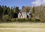 | |||
| Kirkland Village Glencairn Parish Churchyard Including Gillespie Of Peelton Monument | 55°11′39″N 3°52′21″W | Category B | 10313 | | |||
| Shankfoot Bridge (Loch Urr Road Over Castlefairn Water) | 55°09′48″N 3°58′06″W | Category B | 10317 | | |||
| Snade Mill | 55°09′52″N 3°48′48″W | Category B | 10318 | | |||
| Crawfordton School (Main Block) | 55°11′42″N 3°53′33″W | Category B | 10343 | | |||
| Moniaive Village Dunreggan Former F.C. Manse And Stables | 55°11′42″N 3°54′40″W | Category B | 10294 | | |||
| Kirkland Village Cairnside | 55°11′34″N 3°52′15″W | Category C(S) | 10311 | | |||
| Maxwelton House North Gatepiers | 55°11′20″N 3°50′55″W | Category C(S) | 10326 | | |||
| Moniaive Village Chapel Street Bank, Bank House And Gatepiers | 55°11′49″N 3°55′12″W | Category B | 10333 | | |||
| Moniaive Village High Street Bridge A702 Over Dalwhat Water | 55°11′52″N 3°55′07″W | Category B | 10295 | | |||
| Moniaive Village High Street/Ayr Street Tower House | 55°11′51″N 3°55′17″W | Category C(S) | 10297 | | |||
| Moniaive Village Kilneiss House | 55°11′53″N 3°55′41″W | Category A | 10298 | | |||
| Ingleston Martyrs' Monument | 55°11′07″N 3°53′28″W | Category B | 10309 | | |||
| Moniaive Village Renwick Monument | 55°11′54″N 3°55′53″W | Category C(S) | 10315 | | |||
| Kirkland Village Glencairn Parish Manse And Gatepiers | 55°11′37″N 3°52′13″W | Category B | 10321 | | |||
| Lower Ingleston Gatepiers | 55°11′14″N 3°53′36″W | Category B | 10323 | | |||
| Maxwelton House | 55°11′15″N 3°51′06″W | Category B | 10324 | | |||
| Maxwelton House South Gatepiers | 55°11′05″N 3°51′04″W | Category C(S) | 10327 | | |||
| Blackstone Bridge (Glenwhisk-Blackstone Road Over Castlefairn Water) | 55°11′23″N 3°55′13″W | Category C(S) | 10337 | | |||
| Craigdarroch House | 55°11′47″N 3°58′44″W | Category A | 10340 | 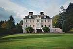 | |||
| Old Crawfordton Farmhouse And Adjoining Vaulted Structure | 55°10′47″N 3°51′40″W | Category B | 10316 | | |||
| Waulkmill Bridge A702 Over Craigdarroch Water | 55°11′41″N 3°55′16″W | Category B | 10320 | | |||
| Castlefairn Bridge (A702 Over Castlefairn Water) | 55°09′42″N 3°59′16″W | Category B | 10339 | | |||
| Moniaive Village Dunreggan Shell Of Former Free Church | 55°11′43″N 3°54′40″W | Category C(S) | 10293 | |
Key
The scheme for classifying buildings in Scotland is:
- Category A: "buildings of national or international importance, either architectural or historic; or fine, little-altered examples of some particular period, style or building type."[1]
- Category B: "buildings of regional or more than local importance; or major examples of some particular period, style or building type, which may have been altered."[1]
- Category C: "buildings of local importance; lesser examples of any period, style, or building type, as originally constructed or moderately altered; and simple traditional buildings which group well with other listed buildings."[1]
In March 2016 there were 47,288 listed buildings in Scotland. Of these, 8 per cent were Category A, and 50 per cent were Category B, with the rest listed at Category C.[2]
Notes
- Sometimes known as OSGB36, the grid reference (where provided) is based on the British national grid reference system used by the Ordnance Survey.
• "Guide to National Grid". Ordnance Survey. Retrieved 2007-12-12.
• "Get-a-map". Ordnance Survey. Retrieved 2007-12-17. - Historic Environment Scotland assign a unique alphanumeric identifier to each designated site in Scotland, for listed buildings this always begins with "LB", for example "LB12345".
References
- All entries, addresses and coordinates are based on data from Historic Scotland. This data falls under the Open Government Licence
- "What is Listing?". Historic Environment Scotland. Retrieved 29 May 2018.
- Scotland's Historic Environment Audit 2016 (PDF). Historic Environment Scotland and the Built Environment Forum Scotland. pp. 15–16. Retrieved 29 May 2018.
This article is issued from Wikipedia. The text is licensed under Creative Commons - Attribution - Sharealike. Additional terms may apply for the media files.