List of listed buildings in Newton Stewart, Dumfries and Galloway
This is a list of listed buildings in the town of Newton Stewart, in Dumfries and Galloway, Scotland.
List
| Name | Location | Date Listed | Grid Ref. [note 1] | Geo-coordinates | Notes | LB Number [note 2] | Image |
|---|---|---|---|---|---|---|---|
| 19-21 Albert Street | 54°57′24″N 4°28′58″W | Category C(S) | 38654 |  | |||
| Corvisel Road, Lynwood And Railings | 54°57′17″N 4°29′11″W | Category C(S) | 38666 | | |||
| Cree Bridge | 54°57′36″N 4°28′57″W | Category A | 38667 | 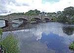 | |||
| King Street Corsbie West | 54°57′55″N 4°29′19″W | Category B | 38671 | | |||
| Penkiln Suspension Footbridge | 54°58′01″N 4°29′08″W | Category B | 38675 | | |||
| 101 And 102 Queen Street, The Crown Hotel | 54°57′12″N 4°28′55″W | Category C(S) | 38682 | | |||
| 36-38 (Even Nos) Victoria Street | 54°57′48″N 4°29′08″W | Category C(S) | 38695 | | |||
| 11 Dashwood Square, Star Inn | 54°57′22″N 4°29′00″W | Category C(S) | 38653 | | |||
| Church Street, Penninghame Graveyard With Mausoleum | 54°57′25″N 4°29′07″W | Category B | 38662 | | |||
| 2, 4, 6 Princes Street And 1 Dashwood Square | 54°57′21″N 4°29′04″W | Category B | 38676 | | |||
| Princes Street, Glenkiel House Former Penninghame Manse With Coach House, Gates, Gatepiers And Railings | 54°57′19″N 4°29′13″W | Category B | 38677 | | |||
| Princes Street, Former Uf Manse | 54°57′19″N 4°29′08″W | Category C(S) | 38679 | | |||
| 1 Victoria Street | 54°57′27″N 4°28′57″W | Category B | 38684 | | |||
| 77-79 (Odd Nos) Victoria Street, Old Town Hall | 54°57′34″N 4°28′59″W | Category B | 38686 | | |||
| 4-10 (Even Nos) Victoria Street | 54°57′28″N 4°28′58″W | Category C(S) | 38689 | | |||
| 76-78 (Even Nos) Victoria Street And Boundary Walls | 54°57′35″N 4°29′01″W | Category B | 38699 | | |||
| Albert Street, Bank Of Scotland | 54°57′25″N 4°28′57″W | Category B | 38655 | | |||
| 37 And 39 Albert Street, Albert House | 54°57′26″N 4°28′57″W | Category C(S) | 38656 | | |||
| Corvisel House, Walled Garden Boundary Walls And Gatepiers | 54°56′58″N 4°28′40″W | Category B | 38664 | | |||
| 12 And 12A Dashwood Square | 54°57′21″N 4°28′59″W | Category C(S) | 38668 | | |||
| Victoria Street, Clydesdale Bank | 54°57′34″N 4°28′59″W | Category C(S) | 38687 | | |||
| 2 Victoria Street, The Central Bar | 54°57′27″N 4°28′58″W | Category B | 38688 | | |||
| Victoria Street, The Galloway Arms Hotel | 54°57′33″N 4°29′00″W | Category B | 38697 | | |||
| Windsor Road, Roman Catholic Presbytery And Churchyward With Boundary Walls, Gatepiers, Gates And Railings | 54°57′41″N 4°29′12″W | Category B | 38702 | | |||
| 4 And 5 Church Street | 54°57′25″N 4°29′03″W | Category C(S) | 38659 | | |||
| Princes Street, Former St Johns Church Hall | 54°57′20″N 4°29′08″W | Category B | 38678 | | |||
| 30 And 32 Victoria Street | 54°57′30″N 4°28′59″W | Category B | 38694 | | |||
| York Road, Former Douglas-Ewart High School, Hill View Apartments | 54°57′39″N 4°29′12″W | Category B | 38703 | | |||
| 41-43 (Odd Nos) Albert Street | 54°57′26″N 4°28′57″W | Category C(S) | 38657 | | |||
| Dashwood Square, The Mcmillan Hall, Railings And Gates | 54°57′21″N 4°29′02″W | Category B | 38669 | | |||
| King Street, Douglas House, Former Douglas School | 54°58′00″N 4°29′15″W | Category A | 38672 | | |||
| 38 King Street, The Beeches | 54°57′49″N 4°29′09″W | Category C(S) | 38673 | | |||
| Queen Street, The Mart, Sale Hall, Office And Railings | 54°57′11″N 4°28′58″W | Category B | 38683 | | |||
| 69-73 (Odd Nos) Victoria Street | 54°57′33″N 4°28′58″W | Category B | 38685 | | |||
| 28 Victoria Street | 54°57′30″N 4°28′59″W | Category C(S) | 38693 | | |||
| York Road, Former Uf Church, Now Newton Stewart Museum With Boundary Walls Gatepiers, And Railings | 54°57′35″N 4°29′10″W | Category B | 38704 | | |||
| 47-49A (Odd Nos) Albert Street | 54°57′27″N 4°28′57″W | Category C(S) | 38658 | | |||
| Church Street, Penninghame Parish Church, St John's (Church_Of Scotland), Boundary Walls And Railings | 54°57′28″N 4°29′07″W | Category A | 38663 | 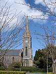 | |||
| 2, Corvisel Road, Prospect House | 54°57′18″N 4°29′10″W | Category C(S) | 38665 | | |||
| 23 King Street, Former Brewery House | 54°57′47″N 4°29′06″W | Category B | 38670 | | |||
| 12 Victoria Street | 54°57′28″N 4°28′58″W | Category C(S) | 38690 | | |||
| 40-44 (Even Nos) Victoria Street, The Royal Bank Of Scotland | 54°57′32″N 4°29′00″W | Category B | 38696 | | |||
| Victoria Street, Monument To 9Th Earl Of Galloway | 54°57′35″N 4°28′59″W | Category B | 38700 | | |||
| Windsor Road, Roman Catholic Church Of Our Lady And St Ninian And Churchyard | 54°57′42″N 4°29′11″W | Category B | 38701 | | |||
| 7 Church Street | 54°57′25″N 4°29′03″W | Category C(S) | 38660 | | |||
| 2 Queen Street, Dashwood House | 54°57′21″N 4°29′00″W | Category B | 38680 | | |||
| Queen Street, Black Horse Hotel With Coach House | 54°57′15″N 4°28′57″W | Category C(S) | 38681 | | |||
| 24-26A (Even Nos) Victoria Street | 54°57′30″N 4°28′59″W | Category C(S) | 38692 | | |||
| 32 King Street | 54°57′47″N 4°29′07″W | Category C(S) | 49412 | | |||
| 13 Church Street | 54°57′27″N 4°29′04″W | Category C(S) | 38661 | | |||
| King Street, Little Corsbie | 54°57′54″N 4°29′13″W | Category B | 38674 | | |||
| 20-22 (Even Nos) Victoria Street | 54°57′29″N 4°28′59″W | Category C(S) | 38691 | | |||
| 70-74 (Even Nos) Victoria Street | 54°57′34″N 4°29′01″W | Category C(S) | 38698 | |
Key
The scheme for classifying buildings in Scotland is:
- Category A: "buildings of national or international importance, either architectural or historic; or fine, little-altered examples of some particular period, style or building type."[1]
- Category B: "buildings of regional or more than local importance; or major examples of some particular period, style or building type, which may have been altered."[1]
- Category C: "buildings of local importance; lesser examples of any period, style, or building type, as originally constructed or moderately altered; and simple traditional buildings which group well with other listed buildings."[1]
In March 2016 there were 47,288 listed buildings in Scotland. Of these, 8 per cent were Category A, and 50 per cent were Category B, with the rest listed at Category C.[2]
Notes
- Sometimes known as OSGB36, the grid reference (where provided) is based on the British national grid reference system used by the Ordnance Survey.
• "Guide to National Grid". Ordnance Survey. Retrieved 12 December 2007.
• "Get-a-map". Ordnance Survey. Retrieved 17 December 2007. - Historic Environment Scotland assign a unique alphanumeric identifier to each designated site in Scotland, for listed buildings this always begins with "LB", for example "LB12345".
References
- All entries, addresses and coordinates are based on data from Historic Scotland. This data falls under the Open Government Licence
- "What is Listing?". Historic Environment Scotland. Retrieved 29 May 2018.
- Scotland's Historic Environment Audit 2016 (PDF). Historic Environment Scotland and the Built Environment Forum Scotland. pp. 15–16. Retrieved 29 May 2018.
| Wikimedia Commons has media related to Penninghame. |
This article is issued from Wikipedia. The text is licensed under Creative Commons - Attribution - Sharealike. Additional terms may apply for the media files.