List of listed buildings in Lockerbie, Dumfries and Galloway
List
| Name | Location | Date Listed | Grid Ref. [note 1] | Geo-coordinates | Notes | LB Number [note 2] | Image |
|---|---|---|---|---|---|---|---|
| High Street, War Memorial | 55°07′19″N 3°21′19″W | Category B | 37563 |  | |||
| 78, 80 High Street | 55°07′19″N 3°21′19″W | Category C(S) | 37576 | | |||
| 82-88 (Even Nos) High Street | 55°07′19″N 3°21′18″W | Category C(S) | 37577 | | |||
| 75 Mains Street | 55°07′02″N 3°21′22″W | Category B | 37585 | | |||
| 14 And 16 Main Street, Masonic Hall | 55°07′10″N 3°21′21″W | Category C(S) | 49584 | | |||
| 2, 3 Ferguson Place | 55°07′21″N 3°20′57″W | Category B | 37562 | | |||
| 77, 79 High Street | 55°07′16″N 3°21′21″W | Category B | 37573 | | |||
| 108, 110 High Street | 55°07′16″N 3°21′19″W | Category C(S) | 37581 | | |||
| Arthur's Place, St George's Villa, Including Gatepiers | 55°07′11″N 3°21′26″W | Category B | 37557 | | |||
| Ashgrove Terrace, All Saints Episcopal Church | 55°07′23″N 3°21′36″W | Category B | 37558 | | |||
| 29 High Street, King's Arms Hotel | 55°07′20″N 3°21′22″W | Category C(S) | 37569 | | |||
| 81, 83 High Street, Bank Of Scotland | 55°07′16″N 3°21′21″W | Category B | 37574 | | |||
| 1, 3 And 5 Station Road, Tower Buildings | 55°07′19″N 3°21′16″W | Category B | 37578 | | |||
| High Street, Town Hall | 55°07′18″N 3°21′17″W | Category A | 37579 | 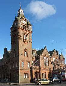 | |||
| Lockerbie Auction Mart | 55°07′32″N 3°21′10″W | Category B | 37583 | | |||
| 11 St Bryde's Terrace, Dryfemount, Including Gatepiers | 55°07′14″N 3°21′32″W | Category B | 37587 | | |||
| 13 St Bryde's Terrace, Fairfield | 55°07′13″N 3°21′31″W | Category B | 37588 | | |||
| 7-11 (Odd Nos) High Street | 55°07′22″N 3°21′23″W | Category C(S) | 37565 | | |||
| 21, 23 High Street, Rogerson And Jamieson | 55°07′21″N 3°21′22″W | Category B | 37567 | | |||
| 55 High Street, Abbey National | 55°07′18″N 3°21′20″W | Category B | 37572 | | |||
| Station Square Lockerbie Station | 55°07′20″N 3°21′14″W | Category B | 37590 | | |||
| 21-27 (Odd Nos) Townhead Street | 55°07′29″N 3°21′25″W | Category B | 37591 | | |||
| 92, 94, 96 High Street | 55°07′18″N 3°21′18″W | Category B | 37580 | | |||
| 44 Mains Street, The Old Manse, Including Boundary Walls And Outbuilding | 55°07′06″N 3°21′22″W | Category B | 37586 | | |||
| Carlisle Road, Somerton House Hotel, Including Gatepiers | 55°06′44″N 3°21′19″W | Category B | 37561 | | |||
| 15, 17 High Street | 55°07′22″N 3°21′23″W | Category C(S) | 37566 | | |||
| 43 High Street | 55°07′19″N 3°21′21″W | Category C(S) | 37570 | | |||
| 47, 49 High Street, Royal Bank Of Scotland | 55°07′19″N 3°21′20″W | Category C(S) | 37571 | | |||
| Arthur's Place, Holy Trinity Roman Catholic Church | 55°07′13″N 3°21′22″W | Category B | 37556 | | |||
| Bridge Street, Library | 55°07′18″N 3°21′16″W | Category B | 37559 | | |||
| Bridge Street, St Cuthbert's Church And Hall (Church Of Scotland) | 55°07′18″N 3°21′07″W | Category B | 37560 | | |||
| High Street, Dryfesdale And Trinity Parish Church, Churchyard And Lodge (Church Of Scotland) | 55°07′25″N 3°21′25″W | Category B | 37564 | | |||
| 25, 27 High Street, Clydesdale Bank | 55°07′21″N 3°21′22″W | Category B | 37568 | | |||
| 10 High Street, Dryfesdale Parish Church Hall | 55°07′24″N 3°21′22″W | Category B | 37575 | | |||
| 27 Mains Street | 55°07′09″N 3°21′23″W | Category C(S) | 37584 | | |||
| 112 High Street, Blue Bell Hotel | 55°07′16″N 3°21′20″W | Category B | 37582 | | |||
| Station Road, Black Bull Inn | 55°07′19″N 3°21′16″W | Category C(S) | 37589 | |
Key
The scheme for classifying buildings in Scotland is:
- Category A: "buildings of national or international importance, either architectural or historic; or fine, little-altered examples of some particular period, style or building type."[1]
- Category B: "buildings of regional or more than local importance; or major examples of some particular period, style or building type, which may have been altered."[1]
- Category C: "buildings of local importance; lesser examples of any period, style, or building type, as originally constructed or moderately altered; and simple traditional buildings which group well with other listed buildings."[1]
In March 2016 there were 47,288 listed buildings in Scotland. Of these, 8 per cent were Category A, and 50 per cent were Category B, with the rest listed at Category C.[2]
Notes
- Sometimes known as OSGB36, the grid reference (where provided) is based on the British national grid reference system used by the Ordnance Survey.
• "Guide to National Grid". Ordnance Survey. Retrieved 12 December 2007.
• "Get-a-map". Ordnance Survey. Retrieved 17 December 2007. - Historic Environment Scotland assign a unique alphanumeric identifier to each designated site in Scotland, for listed buildings this always begins with "LB", for example "LB12345".
References
- All entries, addresses and coordinates are based on data from Historic Scotland. This data falls under the Open Government Licence
- "What is Listing?". Historic Environment Scotland. Retrieved 29 May 2018.
- Scotland's Historic Environment Audit 2016 (PDF). Historic Environment Scotland and the Built Environment Forum Scotland. pp. 15–16. Retrieved 29 May 2018.
| Wikimedia Commons has media related to Lockerbie. |
This article is issued from Wikipedia. The text is licensed under Creative Commons - Attribution - Sharealike. Additional terms may apply for the media files.