List of listed buildings in Tongland, Dumfries and Galloway
This is a list of listed buildings in the civil parish of Tongland in Dumfries and Galloway, Scotland.
List
| Name | Location | Date Listed | Grid Ref. [note 1] | Geo-coordinates | Notes | LB Number [note 2] | Image |
|---|---|---|---|---|---|---|---|
| Tarff, Old Bridge Of Tarff | 54°53′00″N 4°03′20″W | Category B | 17084 |  | |||
| Kirkconnel Farmhouse And Steading | 54°55′12″N 4°04′06″W | Category B | 17118 | | |||
| Argrennan House Walled Garden | 54°53′57″N 4°00′14″W | Category B | 43477 | | |||
| Bogra House | 54°52′35″N 4°01′22″W | Category B | 17116 | | |||
| Brook House, Ringford | 54°53′50″N 4°02′44″W | Category B | 17117 | | |||
| Tongland Bridge | 54°51′28″N 4°02′21″W | Category A | 17125 | 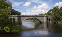 | |||
| Tongland Parish Church (Church Of Scotland) And Churchyard | 54°51′47″N 4°01′49″W | Category B | 17127 | | |||
| Argrennan House | 54°54′03″N 4°00′22″W | Category A | 17114 | 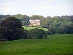 | |||
| Low Bridge Of Tarff | 54°51′51″N 4°03′02″W | Category B | 17120 | | |||
| Argrennan Lodge | 54°54′07″N 4°00′37″W | Category B | 17115 | | |||
| Galloway Electric Power Scheme, Tongland Power Station, Surge Tower And Valve House, Including Boundary Walls | 54°51′35″N 4°02′04″W | Category A | 17126 | 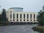 | |||
| Tongland, Old Tongland Bridge | 54°51′38″N 4°01′54″W | Category A | 17123 | | |||
| Tongland Abbey, Tongland Parish Churchyard | 54°51′47″N 4°01′50″W | Category B | 17124 | | |||
| Tarff, High Bridge Of Tarff | 54°53′01″N 4°03′19″W | Category B | 17119 | |
Key
The scheme for classifying buildings in Scotland is:
- Category A: "buildings of national or international importance, either architectural or historic; or fine, little-altered examples of some particular period, style or building type."[1]
- Category B: "buildings of regional or more than local importance; or major examples of some particular period, style or building type, which may have been altered."[1]
- Category C: "buildings of local importance; lesser examples of any period, style, or building type, as originally constructed or moderately altered; and simple traditional buildings which group well with other listed buildings."[1]
In March 2016 there were 47,288 listed buildings in Scotland. Of these, 8 per cent were Category A, and 50 per cent were Category B, with the rest listed at Category C.[2]
Notes
- Sometimes known as OSGB36, the grid reference (where provided) is based on the British national grid reference system used by the Ordnance Survey.
• "Guide to National Grid". Ordnance Survey. Retrieved 2007-12-12.
• "Get-a-map". Ordnance Survey. Retrieved 2007-12-17. - Historic Environment Scotland assign a unique alphanumeric identifier to each designated site in Scotland, for listed buildings this always begins with "LB", for example "LB12345".
References
- All entries, addresses and coordinates are based on data from Historic Scotland. This data falls under the Open Government Licence
- "What is Listing?". Historic Environment Scotland. Retrieved 29 May 2018.
- Scotland's Historic Environment Audit 2016 (PDF). Historic Environment Scotland and the Built Environment Forum Scotland. pp. 15–16. Retrieved 29 May 2018.
| Wikimedia Commons has media related to Tongland. |
This article is issued from Wikipedia. The text is licensed under Creative Commons - Attribution - Sharealike. Additional terms may apply for the media files.