List of listed buildings in Kirkmaiden, Dumfries and Galloway
This is a list of listed buildings in the civil parish of Kirkmaiden, in Dumfries and Galloway, Scotland.
List
| Name | Location | Date Listed | Grid Ref. [note 1] | Geo-coordinates | Notes | LB Number [note 2] | Image |
|---|---|---|---|---|---|---|---|
| Terally, Tile Works Cottages | 54°43′32″N 4°55′18″W | Category B | 13592 |  | |||
| K6 Telephone Kiosk, At Gateway To Mull School | 54°39′45″N 4°54′04″W | Category B | 13557 | | |||
| Kirkbride, Farmhouse And Steading | 54°43′13″N 4°55′31″W | Category C(S) | 13560 | | |||
| Logan, Logan Botanic Garden | 54°44′30″N 4°57′36″W | Category B | 13565 | 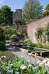 | |||
| Low Currochtrie, Farmhouse | 54°41′50″N 4°55′06″W | Category C(S) | 13573 | | |||
| Mull Of Galloway Lighthouse, Lighthouse Keepers' Houses And Boundary Walls | 54°38′06″N 4°51′26″W | Category A | 13578 | 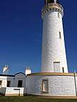 | |||
| Drummore, 5 Shore Street, Ship Inn | 54°41′28″N 4°53′36″W | Category C(S) | 10101 | | |||
| East Tarbet, Cottage And Quay | 54°38′22″N 4°52′35″W | Category B | 10126 | | |||
| Drummore, 19 Shore Street | 54°41′29″N 4°53′40″W | Category B | 10131 | | |||
| Kennedy's Cairn | 54°38′08″N 4°52′25″W | Category C(S) | 13558 | | |||
| Logan, Bridge | 54°44′08″N 4°57′49″W | Category C(S) | 13561 | | |||
| Low Drummore, Farmhouse | 54°41′17″N 4°53′41″W | Category C(S) | 13574 | | |||
| Mull Hill, Beacon | 54°44′13″N 4°59′10″W | Category C(S) | 13575 | | |||
| Port Logan, Laigh Row, Port Logan Lodge | 54°43′25″N 4°57′22″W | Category C(S) | 13585 | | |||
| Drummore, 17 Mill Street, Ingleston | 54°41′22″N 4°53′43″W | Category C(S) | 10090 | | |||
| Drummore, 33 Mill Street | 54°41′23″N 4°53′41″W | Category C(S) | 10096 | | |||
| Terally Brick And Tile Works | 54°43′35″N 4°55′13″W | Category B | 13590 | | |||
| Longbows (Former Drummore School And Schoolhouse) | 54°41′34″N 4°54′19″W | Category C(S) | 13571 | | |||
| Port Logan Lighthouse Tower And Pier | 54°43′26″N 4°57′36″W | Category B | 13586 | | |||
| St Agnes's (Former) Church And Manse, With Railings | 54°45′08″N 4°56′08″W | Category B | 13589 | | |||
| Drummore, 41 Mill Street | 54°41′24″N 4°53′39″W | Category C(S) | 10097 | | |||
| Drummore, 36 And 38 Stair Street, With Railings, Gates And Gatepiers | 54°41′31″N 4°53′48″W | Category C(S) | 10124 | | |||
| Terally Brick, Coal Store | 54°43′47″N 4°55′00″W | Category C(S) | 13591 | | |||
| Logan Mills, Fishing Store | 54°45′12″N 4°55′43″W | Category C(S) | 13568 | | |||
| Port Logan, Laigh Row (Mr Davey) | 54°43′24″N 4°57′24″W | Category C(S) | 13584 | | |||
| Drummore, 57 Mill Street, Warehouse | 54°41′28″N 4°53′34″W | Category C(S) | 10098 | | |||
| Drummore, 13 Shore Street, Norwood | 54°41′29″N 4°53′39″W | Category B | 10103 | | |||
| Drummore, 15 Shore Street, Anwoth | 54°41′29″N 4°53′39″W | Category B | 10129 | | |||
| Logan, Hen Knowe Cottages | 54°44′46″N 4°57′43″W | Category C(S) | 13563 | | |||
| Logan Mills, Sawmill, With Water-Wheel | 54°45′07″N 4°55′46″W | Category B | 13569 | | |||
| Logan Windmill | 54°45′13″N 4°55′50″W | Category A | 13570 | 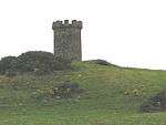 | |||
| Mullhill, Farmhouse | 54°44′18″N 4°58′54″W | Category C(S) | 13576 | | |||
| Mull School And Schoolhouse | 54°39′46″N 4°54′05″W | Category C(S) | 13579 | | |||
| Old Parish Church Of Kirkmaiden, With Graveyard, Graveyard Walls And Gatepiers | 54°41′32″N 4°54′42″W | Category A | 13581 | 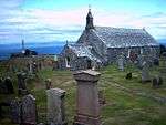 | |||
| Port Logan, 15 Laigh Row | 54°43′23″N 4°57′25″W | Category C(S) | 13583 | | |||
| Balgowan, Farmhouse | 54°44′53″N 4°55′58″W | Category B | 10086 | | |||
| Chapel Rossan | 54°45′53″N 4°56′27″W | Category B | 10088 | | |||
| Drummore, 29 And 31 Mill Street, Queen's Hotel | 54°41′23″N 4°53′41″W | Category B | 10092 | | |||
| Drummore, Saint Medan's Church Boundary Walls, Railings, Gates And War Memorial | 54°41′27″N 4°53′44″W | Category B | 10100 | | |||
| Drummore, 40 Stair Street | 54°41′31″N 4°53′49″W | Category C(S) | 10125 | | |||
| Logan, Logan Court (Former Coach House And Stables) | 54°44′46″N 4°57′34″W | Category B | 13566 | | |||
| Port Logan School | 54°43′47″N 4°57′21″W | Category C(S) | 13587 | | |||
| Castle Clanyard | 54°41′46″N 4°56′12″W | Category C(S) | 10087 | | |||
| Drummore, Mill Street, Wylie's Mill, With Water-Wheel | 54°41′27″N 4°53′33″W | Category C(S) | 10089 | | |||
| Drummore, 17 Shore Street | 54°41′29″N 4°53′40″W | Category B | 10130 | | |||
| Drummore, Stair Street, Lamb Monument | 54°41′27″N 4°53′43″W | Category C(S) | 10132 | | |||
| Logan, Folly Tower | 54°44′39″N 4°57′53″W | Category C(S) | 13562 | | |||
| Low Clanyard, Farmhouse | 54°41′46″N 4°56′20″W | Category B | 13572 | | |||
| Old Kirkmaiden House (Former Manse) | 54°41′40″N 4°54′58″W | Category B | 13580 | | |||
| Port Logan, 14 Laigh Row | 54°43′23″N 4°57′25″W | Category C(S) | 13582 | | |||
| Port Logan Schoolhouse | 54°43′49″N 4°57′19″W | Category C(S) | 13588 | | |||
| Drummore, 19 Mill Street | 54°41′22″N 4°53′43″W | Category C(S) | 10091 | | |||
| Drummore, 4 Mill Street, Cairnsmore | 54°41′20″N 4°53′44″W | Category C(S) | 10099 | | |||
| Killumpha, Farmhouse | 54°43′34″N 4°55′57″W | Category B | 13559 | | |||
| Logan House | 54°44′39″N 4°57′32″W | Category A | 13564 | .jpg) | |||
| Logan, Logan Fish Pond, Cottage And Bathing Hut | 54°43′50″N 4°57′53″W | Category B | 13567 | | |||
| Auchness, Farmhouse And Cottage | 54°45′37″N 4°56′38″W | Category B | 10085 | | |||
| Drummore, 11 Shore Street, Tudor House | 54°41′29″N 4°53′38″W | Category B | 10102 | |
Key
The scheme for classifying buildings in Scotland is:
- Category A: "buildings of national or international importance, either architectural or historic; or fine, little-altered examples of some particular period, style or building type."[1]
- Category B: "buildings of regional or more than local importance; or major examples of some particular period, style or building type, which may have been altered."[1]
- Category C: "buildings of local importance; lesser examples of any period, style, or building type, as originally constructed or moderately altered; and simple traditional buildings which group well with other listed buildings."[1]
In March 2016 there were 47,288 listed buildings in Scotland. Of these, 8 per cent were Category A, and 50 per cent were Category B, with the rest listed at Category C.[2]
Notes
- Sometimes known as OSGB36, the grid reference (where provided) is based on the British national grid reference system used by the Ordnance Survey.
• "Guide to National Grid". Ordnance Survey. Retrieved 2007-12-12.
• "Get-a-map". Ordnance Survey. Retrieved 2007-12-17. - Historic Environment Scotland assign a unique alphanumeric identifier to each designated site in Scotland, for listed buildings this always begins with "LB", for example "LB12345".
References
- All entries, addresses and coordinates are based on data from Historic Scotland. This data falls under the Open Government Licence
- "What is Listing?". Historic Environment Scotland. Retrieved 29 May 2018.
- Scotland's Historic Environment Audit 2016 (PDF). Historic Environment Scotland and the Built Environment Forum Scotland. pp. 15–16. Retrieved 29 May 2018.
| Wikimedia Commons has media related to Kirkmaiden. |
This article is issued from Wikipedia. The text is licensed under Creative Commons - Attribution - Sharealike. Additional terms may apply for the media files.