List of listed buildings in New Galloway, Dumfries and Galloway
List
| Name | Location | Date Listed | Grid Ref. [note 1] | Geo-coordinates | Notes | LB Number [note 2] | Image |
|---|---|---|---|---|---|---|---|
| High Street, Meadowbank Cottages | 55°04′20″N 4°08′27″W | Category C(S) | 38473 |  | |||
| The Old School, Glenkens Community Arts Centre With Boundary Walls, Gatepiers And Railings | 55°04′31″N 4°08′28″W | Category C(S) | 49306 | | |||
| Clydesdale Bank | 55°04′34″N 4°08′24″W | Category B | 38465 | | |||
| West Port, The Thorn | 55°04′24″N 4°08′28″W | Category B | 38478 | | |||
| Greenhead Brae, Greenhead And Greenhead Cottage | 55°04′22″N 4°08′33″W | Category C(S) | 38467 | | |||
| High Street, Baddaroch | 55°04′23″N 4°08′28″W | Category C(S) | 38470 | | |||
| High Street, Copper Cottage | 55°04′22″N 4°08′27″W | Category C(S) | 38471 | | |||
| Brae Cottage, Off Wylies Brae | 55°04′26″N 4°08′26″W | Category B | 38464 | | |||
| High Street, Kenburn And Burnbank | 55°04′28″N 4°08′27″W | Category B | 38472 | | |||
| Meadowbank House | 55°04′20″N 4°08′24″W | Category C(S) | 38476 | | |||
| High Street, Town Hall | 55°04′23″N 4°08′27″W | Category B | 38475 | 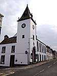 | |||
| High Street, Corner House | 55°04′24″N 4°08′28″W | Category B | 38468 | | |||
| High Street, Mill House | 55°04′28″N 4°08′28″W | Category B | 38474 | | |||
| East Port, Hillboro Cottage | 55°04′24″N 4°08′26″W | Category B | 38466 | | |||
| High Street, Inton | 55°04′23″N 4°08′28″W | Category C(S) | 38469 | |
Key
The scheme for classifying buildings in Scotland is:
- Category A: "buildings of national or international importance, either architectural or historic; or fine, little-altered examples of some particular period, style or building type."[1]
- Category B: "buildings of regional or more than local importance; or major examples of some particular period, style or building type, which may have been altered."[1]
- Category C: "buildings of local importance; lesser examples of any period, style, or building type, as originally constructed or moderately altered; and simple traditional buildings which group well with other listed buildings."[1]
In March 2016 there were 47,288 listed buildings in Scotland. Of these, 8 per cent were Category A, and 50 per cent were Category B, with the rest listed at Category C.[2]
Notes
- Sometimes known as OSGB36, the grid reference (where provided) is based on the British national grid reference system used by the Ordnance Survey.
• "Guide to National Grid". Ordnance Survey. Retrieved 2007-12-12.
• "Get-a-map". Ordnance Survey. Retrieved 2007-12-17. - Historic Environment Scotland assign a unique alphanumeric identifier to each designated site in Scotland, for listed buildings this always begins with "LB", for example "LB12345".
References
- All entries, addresses and coordinates are based on data from Historic Scotland. This data falls under the Open Government Licence
- "What is Listing?". Historic Environment Scotland. Retrieved 29 May 2018.
- Scotland's Historic Environment Audit 2016 (PDF). Historic Environment Scotland and the Built Environment Forum Scotland. pp. 15–16. Retrieved 29 May 2018.
| Wikimedia Commons has media related to New Galloway. |
This article is issued from Wikipedia. The text is licensed under Creative Commons - Attribution - Sharealike. Additional terms may apply for the media files.