List of listed buildings in Morton, Dumfries and Galloway
This is a list of listed buildings in the civil parish of Morton in Dumfries and Galloway, Scotland.
List
| Name | Location | Date Listed | Grid Ref. [note 1] | Geo-coordinates | Notes | LB Number [note 2] | Image |
|---|---|---|---|---|---|---|---|
| Thornhill Village Townhead Street Dalgarnoc (Former Up Manse) House And Gatepiers | 55°14′21″N 3°46′04″W | Category B | 17329 |  | |||
| Thornhill Village East Morton Street Primary School | 55°14′33″N 3°45′44″W | Category B | 17340 | | |||
| Thornhill Village 1, 1A North Drumlanrig Street | 55°14′38″N 3°46′06″W | Category B | 17359 | | |||
| Thornhill Village 86 South Drumlanrig Street | 55°14′20″N 3°45′44″W | Category B | 17368 | | |||
| Laught Mains Farmhouse And Barn To South East | 55°13′53″N 3°44′12″W | Category B | 17380 | | |||
| Thornhill Village 95A South Drumlanrig Street Bank House | 55°14′22″N 3°45′49″W | Category B | 17325 | | |||
| Nithbank House And Gatepiers | 55°14′52″N 3°46′39″W | Category C(S) | 17335 | | |||
| Thornhill Village East Morton Street School Caretaker's House | 55°14′33″N 3°45′42″W | Category B | 17339 | | |||
| 7,8,9 Carronbridge Village | 55°15′49″N 3°46′47″W | Category C(S) | 17351 | | |||
| Thornhill, East Morton Street Police Station And House | 55°14′33″N 3°45′46″W | Category C(S) | 17356 | | |||
| Thornhill Village 37, 39 North Drumlanrig Street | 55°14′30″N 3°45′57″W | Category B | 17361 | | |||
| Thornhill Village 161 North Drumlanrig Street | 55°14′37″N 3°46′08″W | Category B | 17363 | | |||
| Thornhill Village 84 South Drumlanrig Street | 55°14′20″N 3°45′45″W | Category C(S) | 17367 | | |||
| Dabton House, Stables | 55°15′32″N 3°46′23″W | Category B | 17372 | | |||
| Drum Farm House And Steading | 55°16′31″N 3°46′19″W | Category B | 17374 | | |||
| Carronhill East Carronhill And West Carronhill | 55°15′58″N 3°46′29″W | Category C(S) | 17385 | | |||
| Thornhill Village South Drumlanrig Street George Hotel (South Block Only) | 55°14′24″N 3°45′52″W | Category C(S) | 17327 | | |||
| Rowantree House (Formerly Upper Nithsdale Combination Poorhouse) | 55°14′54″N 3°43′40″W | Category B | 17336 | | |||
| Broomrigg Cottages | 55°16′12″N 3°46′41″W | Category B | 17348 | | |||
| Waterside Mains Farmhouse And Steading Range Adjoining House | 55°15′19″N 3°46′47″W | Category B | 17355 | | |||
| Thornhill Village Morton Parish Church | 55°14′38″N 3°45′34″W | Category B | 17357 | | |||
| Thornhill Village 66, 67, 68 South Drumlanrig Street Freemason's Hill | 55°14′24″N 3°45′49″W | Category B | 17366 | | |||
| 8, 9, 10 Gatelawbridge And Old Stable House | 55°00′11″N 4°51′31″W | Category B | 17376 | | |||
| Hayfield Farmhouse And Steading | 55°15′10″N 3°44′07″W | Category B | 17378 | | |||
| Holmhill House And Courtyard Blocks | 55°14′23″N 3°46′34″W | Category B | 17379 | | |||
| Thornhill, Wallace Hall Primary School | 55°14′33″N 3°45′40″W | Category C(S) | 50174 | | |||
| Morton Old Church Churchyard Enclosure And Gatepiers | 55°15′16″N 3°44′51″W | Category B | 17333 | | |||
| Thornhill Village Morton Parish Manse | 55°14′43″N 3°45′33″W | Category B | 17358 | | |||
| Thornhill Village 57, 58 South Drumlanrig Street | 55°14′26″N 3°45′52″W | Category B | 17364 | | |||
| Dabton House | 55°15′30″N 3°46′25″W | Category B | 17370 | | |||
| Dabton House Walled Garden | 55°15′34″N 3°46′19″W | Category B | 17373 | | |||
| Drumcork Farmhouse | 55°15′22″N 3°45′36″W | Category C(S) | 17375 | | |||
| Thornhill Village 99-102 South Drumlanrig Street (Numbers Inclusive) | 55°14′23″N 3°45′50″W | Category C(S) | 17326 | | |||
| Thornhill Village 63, 64 South Drumlanrig Street | 55°14′25″N 3°45′50″W | Category B | 17365 | | |||
| Carronhill Glen Railway Viaduct And Bridge Over Newlands/Drum Road | 55°15′57″N 3°46′10″W | Category B | 17369 | | |||
| Dabton House, Lodge And Gatepiers | 55°15′25″N 3°46′31″W | Category B | 17371 | | |||
| Mansefield House And Garden Walls | 55°15′10″N 3°44′53″W | Category B | 17382 | | |||
| Thornhill Village 1 West Morton Street | 55°14′26″N 3°45′55″W | Category C(S) | 17330 | | |||
| Thornhill Village 138, 140 North Drumlanrig Street | 55°14′31″N 3°46′01″W | Category B | 17362 | | |||
| Longmyre Farmhouse And North And South Ranges Of Steading | 55°15′01″N 3°46′20″W | Category C(S) | 17381 | | |||
| Thornhill Village East Morton Street Joseph Thomson Monument | 55°14′31″N 3°45′46″W | Category B | 17338 | | |||
| 35 Carronbridge Village | 55°15′50″N 3°46′47″W | Category C(S) | 17352 | | |||
| 36 Carronbridge Village Learig | 55°15′50″N 3°46′46″W | Category C(S) | 17353 | | |||
| Thornhill Village 112 South Drumlanrig Street/West Morton Street Buccleuch Hotel | 55°14′25″N 3°45′54″W | Category B | 17328 | | |||
| Thornhill Village The Cross | 55°14′27″N 3°45′54″W | Category A | 17337 | 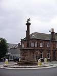 | |||
| Burn Farmhouse And Steading | 55°16′00″N 3°43′34″W | Category B | 17349 | | |||
| Carronbridge Village Carronbridge Sawmill | 55°15′44″N 3°46′55″W | Category B | 17354 | | |||
| Thornhill Village 28, 29 North Drumlanrig Street | 55°14′31″N 3°45′58″W | Category C(S) | 17360 | | |||
| Gill Burn Viaduct | 55°17′14″N 3°45′51″W | Category B | 17377 | | |||
| Morton Mains Haybarn | 55°16′40″N 3°45′11″W | Category B | 17383 | |
Key
The scheme for classifying buildings in Scotland is:
- Category A: "buildings of national or international importance, either architectural or historic; or fine, little-altered examples of some particular period, style or building type."[1]
- Category B: "buildings of regional or more than local importance; or major examples of some particular period, style or building type, which may have been altered."[1]
- Category C: "buildings of local importance; lesser examples of any period, style, or building type, as originally constructed or moderately altered; and simple traditional buildings which group well with other listed buildings."[1]
In March 2016 there were 47,288 listed buildings in Scotland. Of these, 8 per cent were Category A, and 50 per cent were Category B, with the rest listed at Category C.[2]
Notes
- Sometimes known as OSGB36, the grid reference (where provided) is based on the British national grid reference system used by the Ordnance Survey.
• "Guide to National Grid". Ordnance Survey. Retrieved 2007-12-12.
• "Get-a-map". Ordnance Survey. Retrieved 2007-12-17. - Historic Environment Scotland assign a unique alphanumeric identifier to each designated site in Scotland, for listed buildings this always begins with "LB", for example "LB12345".
References
- All entries, addresses and coordinates are based on data from Historic Scotland. This data falls under the Open Government Licence
- "What is Listing?". Historic Environment Scotland. Retrieved 29 May 2018.
- Scotland's Historic Environment Audit 2016 (PDF). Historic Environment Scotland and the Built Environment Forum Scotland. pp. 15–16. Retrieved 29 May 2018.
This article is issued from Wikipedia. The text is licensed under Creative Commons - Attribution - Sharealike. Additional terms may apply for the media files.