List of listed buildings in Sanquhar, Dumfries and Galloway
This is a list of listed buildings in the civil parish of Sanquhar in Dumfries and Galloway, Scotland.
List
| Name | Location | Date Listed | Grid Ref. [note 1] | Geo-coordinates | Notes | LB Number [note 2] | Image |
|---|---|---|---|---|---|---|---|
| High Street, Tolbooth/Town House | 55°22′05″N 3°55′30″W | Category A | 40540 | 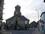 | |||
| 5, 7 High Street, Including Mary Millar's Shop | 55°22′05″N 3°55′29″W | Category C(S) | 40542 |  | |||
| 39, 41 High Street, Post Office And House | 55°22′04″N 3°55′24″W | Category B | 40547 | | |||
| 14-24 High Street (Even Nos) | 55°22′04″N 3°55′28″W | Category C(S) | 40553 | | |||
| 104-106 High Street, Library And House | 55°22′00″N 3°55′17″W | Category C(S) | 40560 | | |||
| Laurie's Wynd, Crichton Schoolhouse | 55°22′06″N 3°55′18″W | Category B | 40562 | | |||
| Sanquar House (Parish Manse) And Walled Garden | 55°22′14″N 3°56′02″W | Category B | 40565 | | |||
| Former Station, Stationmaster's House | 55°22′14″N 3°55′29″W | Category C(S) | 40566 | | |||
| Wanlockhead Village 1-18 (Numbers Inclusive) Fraser Terrace | 55°23′47″N 3°46′45″W | Category B | 17191 | | |||
| Wanlockhead Village 1-4 Mitchell Place (Numbers Inclusive) | 55°23′49″N 3°46′56″W | Category B | 17194 | | |||
| Wanlockhead Village School | 55°23′51″N 3°46′47″W | Category C(S) | 17195 | | |||
| Wanlockhead Village Straight Steps (Cottages At Beam Engine) | 55°23′58″N 3°47′08″W | Category C(S) | 17197 | | |||
| Blackaddie Bridge (Over River Nith) | 55°21′57″N 3°56′04″W | Category B | 40536 | | |||
| 100-102 High Street, Council Offices | 55°22′00″N 3°55′18″W | Category C(S) | 40559 | | |||
| Wanlockhead Village Burnside | 55°23′50″N 3°46′54″W | Category C(S) | 17189 | | |||
| Wanlockhead Village Former Wanlock Manse | 55°23′52″N 3°46′50″W | Category C(S) | 17230 | | |||
| Back Burn Road Bridge (Over Back Burn) | 55°21′03″N 3°54′03″W | Category C(S) | 17251 | | |||
| Eliock House Bridge (Main Driveway Over Garral Burn) | 55°20′45″N 3°53′51″W | Category C(S) | 17257 | | |||
| 31,33 High Street | 55°22′05″N 3°55′25″W | Category C(S) | 40545 | | |||
| High Street, St Ninians Church, Hall, Gatepiers And Screen Wall | 55°21′58″N 3°55′10″W | Category B | 40551 | | |||
| Wanlockhead Village Meadow Foot Burial Enclosure | 55°24′11″N 3°47′40″W | Category C(S) | 17193 | | |||
| Craigdarroch Farmhouse | 55°20′32″N 3°53′11″W | Category C(S) | 17253 | | |||
| Crawick Viaduct | 55°22′39″N 3°55′56″W | Category B | 17254 | | |||
| Euchan Bridge (Over Euchan Water) | 55°21′38″N 3°55′55″W | Category C(S) | 17258 | | |||
| Kello Bridge (Over Kello Water At Old Kelloside) | 55°22′34″N 3°59′31″W | Category B | 17259 | | |||
| Wanlockhead Village, Belton House | 55°23′57″N 3°46′32″W | Category C(S) | 17261 | | |||
| 63 High Street, Bank Of Scotland | 55°22′03″N 3°55′21″W | Category B | 40548 | | |||
| 71, 73 High Street | 55°22′02″N 3°55′18″W | Category B | 40549 | | |||
| 36 And 40 High Street | 55°22′03″N 3°55′26″W | Category C(S) | 40556 | | |||
| Saint Mary Street, Evangelical Union Church | 55°22′09″N 3°55′26″W | Category C(S) | 40564 | | |||
| Wanlockhead Village Stewart Place | 55°23′54″N 3°47′00″W | Category B | 17196 | | |||
| Church Road, Sanquhar Parish Church, (St Bride`S) And Churchyard Including Hamilton Monument | 55°22′13″N 3°55′41″W | Category B | 40538 | | |||
| Crawick Bridge, (A76 Over Crawick Water) | 55°22′30″N 3°56′10″W | Category B | 40539 | | |||
| High Street, Monument | 55°22′01″N 3°55′16″W | Category C(S) | 40550 | | |||
| Mennock Viaduct | 55°21′08″N 3°52′49″W | Category B | 17260 | | |||
| 1, 3 High Street, Nithsdale Hotel | 55°22′06″N 3°55′30″W | Category C(S) | 40541 | | |||
| 27, 29 High Street | 55°22′05″N 3°55′26″W | Category C(S) | 40544 | | |||
| 35, 37 High Street | 55°22′04″N 3°55′25″W | Category C(S) | 40546 | | |||
| 74, 76 High Street | 55°22′01″N 3°55′20″W | Category B | 40557 | | |||
| Laurie's Wynd, Former Crichton School | 55°22′06″N 3°55′18″W | Category B | 40561 | | |||
| Wanlockhead Village Church (Church Of Scotland) | 55°23′56″N 3°47′05″W | Category C(S) | 17190 | | |||
| Wanlockhead Village Library | 55°23′52″N 3°46′47″W | Category A | 17192 | 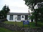 | |||
| Eliock House | 55°20′47″N 3°53′56″W | Category B | 17256 | | |||
| 78-86 High Street (Even Numbers) | 55°22′01″N 3°55′19″W | Category B | 40558 | | |||
| Wanlockhead Village Wanlock House | 55°23′55″N 3°46′38″W | Category C(S) | 17229 | | |||
| Eliock Bridge | 55°21′14″N 3°53′17″W | Category B | 17255 | | |||
| 2 Church Road | 55°22′06″N 3°55′31″W | Category B | 40537 | | |||
| 11, 13 High Street | 55°22′05″N 3°55′29″W | Category C(S) | 40543 | | |||
| High Street, St Ninian's Manse | 55°21′58″N 3°55′10″W | Category C(S) | 40552 | | |||
| 26 High Street, Royal Bank Of Scotland | 55°22′03″N 3°55′27″W | Category B | 40554 | | |||
| 28-34 High Street | 55°22′03″N 3°55′27″W | Category C(S) | 40555 | | |||
| Queensberry Square, School (Range To North East) | 55°22′11″N 3°55′39″W | Category B | 40563 | |
Key
The scheme for classifying buildings in Scotland is:
- Category A: "buildings of national or international importance, either architectural or historic; or fine, little-altered examples of some particular period, style or building type."[1]
- Category B: "buildings of regional or more than local importance; or major examples of some particular period, style or building type, which may have been altered."[1]
- Category C: "buildings of local importance; lesser examples of any period, style, or building type, as originally constructed or moderately altered; and simple traditional buildings which group well with other listed buildings."[1]
In March 2016 there were 47,288 listed buildings in Scotland. Of these, 8 per cent were Category A, and 50 per cent were Category B, with the rest listed at Category C.[2]
Notes
- Sometimes known as OSGB36, the grid reference (where provided) is based on the British national grid reference system used by the Ordnance Survey.
• "Guide to National Grid". Ordnance Survey. Retrieved 12 December 2007.
• "Get-a-map". Ordnance Survey. Retrieved 17 December 2007. - Historic Environment Scotland assign a unique alphanumeric identifier to each designated site in Scotland, for listed buildings this always begins with "LB", for example "LB12345".
References
- All entries, addresses and coordinates are based on data from Historic Scotland. This data falls under the Open Government Licence
- "What is Listing?". Historic Environment Scotland. Retrieved 29 May 2018.
- Scotland's Historic Environment Audit 2016 (PDF). Historic Environment Scotland and the Built Environment Forum Scotland. pp. 15–16. Retrieved 29 May 2018.
| Wikimedia Commons has media related to Sanquhar. |
This article is issued from Wikipedia. The text is licensed under Creative Commons - Attribution - Sharealike. Additional terms may apply for the media files.