List of listed buildings in Balmaghie, Dumfries and Galloway
List
| Name | Location | Date Listed | Grid Ref. [note 1] | Geo-coordinates | Notes | LB Number [note 2] | Image |
|---|---|---|---|---|---|---|---|
| Hensol Lodge And Gates | 55°00′26″N 4°05′25″W | Category B | 3417 |  | |||
| Glentoo Farmhouse And Horsemill With Steading | 54°56′10″N 4°01′17″W | Category B | 3423 | | |||
| Laurieston, Crockett Memorial | 54°57′44″N 4°03′32″W | Category C(S) | 3426 | | |||
| Laurieston, Windhover And Lilac Grove | 54°57′40″N 4°03′35″W | Category C(S) | 3427 | | |||
| Laurieston Hall Stables | 54°58′07″N 4°04′04″W | Category B | 3424 | | |||
| Laurieston, Chestnut House | 54°57′39″N 4°03′35″W | Category B | 3425 | | |||
| Gordon Chapel, Quarter Mile West Of Glenlochar Bridge | 54°57′28″N 3°59′27″W | Category B | 3414 | | |||
| Laurieston Hall | 54°58′07″N 4°04′11″W | Category B | 3418 | | |||
| Little Duchrae, Cottage And Farm Steading | 54°59′51″N 4°05′07″W | Category C(S) | 3428 | | |||
| Threave Castle | 54°56′21″N 3°58′11″W | Category A | 3408 |  | |||
| Hensol House | 55°00′19″N 4°04′20″W | Category A | 3415 | | |||
| Hensol House, The Lainshaw Sundial | 55°00′19″N 4°04′19″W | Category A | 3416 | 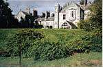 | |||
| Balmaghie Parish Church And Churchyard, Church Of Scotland | 54°58′30″N 3°59′49″W | Category B | 3422 | | |||
| Livingston | 54°59′13″N 4°00′37″W | Category B | 3407 | |
Key
The scheme for classifying buildings in Scotland is:
- Category A: "buildings of national or international importance, either architectural or historic; or fine, little-altered examples of some particular period, style or building type."[1]
- Category B: "buildings of regional or more than local importance; or major examples of some particular period, style or building type, which may have been altered."[1]
- Category C: "buildings of local importance; lesser examples of any period, style, or building type, as originally constructed or moderately altered; and simple traditional buildings which group well with other listed buildings."[1]
In March 2016 there were 47,288 listed buildings in Scotland. Of these, 8 per cent were Category A, and 50 per cent were Category B, with the rest listed at Category C.[2]
Notes
- Sometimes known as OSGB36, the grid reference (where provided) is based on the British national grid reference system used by the Ordnance Survey.
• "Guide to National Grid". Ordnance Survey. Retrieved 2007-12-12.
• "Get-a-map". Ordnance Survey. Retrieved 2007-12-17. - Historic Environment Scotland assign a unique alphanumeric identifier to each designated site in Scotland, for listed buildings this always begins with "LB", for example "LB12345".
References
- All entries, addresses and coordinates are based on data from Historic Scotland. This data falls under the Open Government Licence
- "What is Listing?". Historic Environment Scotland. Retrieved 29 May 2018.
- Scotland's Historic Environment Audit 2016 (PDF). Historic Environment Scotland and the Built Environment Forum Scotland. pp. 15–16. Retrieved 29 May 2018.
| Wikimedia Commons has media related to Balmaghie. |
This article is issued from Wikipedia. The text is licensed under Creative Commons - Attribution - Sharealike. Additional terms may apply for the media files.