Cachar district
Cachar is an administrative district in the state of Assam in India. It makes up the Barak Valley alongside Hailakandi and Karimganj.
Cachar | |
|---|---|
Districts of Assam | |
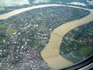 Bird's eye view of Silchar. | |
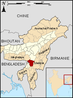 Cachar district's location in Assam | |
| Country | India |
| State | Assam |
| Division | Barak Valley |
| Headquarters | Silchar |
| Area | |
| • Total | 3,786 km2 (1,462 sq mi) |
| Population (2011) | |
| • Total | 1,736,617 |
| • Density | 460/km2 (1,200/sq mi) |
| Demonym(s) | Cachari (Kachari) Sylheti |
| Time zone | UTC+05:30 (IST) |
| ISO 3166 code | IN-AS-CA |
| Official language | Bengali |
| Most spoken language | Sylheti[1] |
| Website | http://cachar.gov.in/ |
| Wikisource has the text of the 1911 Encyclopædia Britannica article Cachar. |
Etymology
The name Cachar traces its origin to the Kachari kingdom.
History
Pre-independence period
Cachar was originally part of the Tripura kingdom . This province later merged with the greater Dimasa Kachari Kingdom. The Last King of Cachar was Raja Govindrachandradwajanarayana Hasnu. During his period Khaspur was the Capital of Cachar (Kachar). Cachar was another native kingdom that fell victim to the imperialist design of the British. The Kingdom of Cachar was being ruled by two rulers having clearly defined areas of control. In the plains (southern portion of Cachar) Govindrachandradwajanarayana Hasnu was the ruling prince. Immediately after his assassination by Gambhir Singh, then king of Manipur, British annexed it to their dominion in India (1832). Tularam was the ruling chief of the hilly tract (northern portion of Cachar or Dima Hasao). His territories were annexed after he died in 1854. Thus entire Cachar came under the British occupation. While south Cachar was annexed under Robertson, the hilly tract of Cachar came under British occupation when Jenkins was the Commissioner of Assam. [2]
Independence movement
The history of the district includes the active participation and support of its people in the Indian independence movement. Many leaders, such as Kamini Kumar Chanda, his son Arun Kumar Chanda and Abdul Matlib Mazumdar etc. led the people of the district to fight for the cause. While Chanda was instrumental in garnering support of the Bengali Hindus, Mazumdar was one of the prominent Muslim leaders of Eastern India to oppose the partition of India on communal lines. Mazumdar, along with Fakhruddin Ali Ahmed, (who later became the 5th President of India) became the most prominent Muslim opponents to the demand for a separate Muslim state of Pakistan, especially in the eastern part of the country. To counter the rising popularity of Muslim League, he successfully organised the Jamiat Ulema-e-Hind movement in Assam. Jamiat was an ally of the Congress having a mass following among the nationalist Muslims. In the very crucial 1946 General Elections, conducted just on the eve of India’s independence, he wrested the Muslim majority Hailakandi seat from the hold of the Muslim League. That victory virtually sealed the hopes and aspirations of the Muslim League to include southern Assam, including Cachar, in Pakistan.
Assam's Surma Valley (now partly in Bangladesh) had Muslim-majority population. On the eve of partition, hectic activities intensified by the Muslim League as well Congress with the former having an edge. A referendum had been proposed for Sylhet Region (now mostly in Bangladesh). Mazumdar along with Basanta Kumar Das (then Home Minister of Assam) travelled throughout the valley organising the Congress and addressing meetings educating the masses about the outcome of partition on the basis of religion. On 20 February 1947, Mazumdar inaugurated a convention – Assam Nationalist Muslim's Convention at Silchar. There after another big meeting was held at Silchar on 8 June 1947.[3] Both the meetings, which were attended by a large section of Muslims, paid dividend. He was also among the few who were instrumental in retaining the Barak Valley region of Assam, especially Karimganj with India.[4][5] Mazumdar was the leader of the delegation that pleaded before the Radcliffe Commission that ensured that a part of Sylhet, the present Karimganj district, remained with India.[6][11]. Arun Kumar Chanda did not join Bordoloi cabinet in 1946 but preferred to do social work as a legislator and also to uplift the premier educational institution, G.C. College. Unfortunately he soon died leaving a huge vacuum of an able Bengali Hindu leader with a secular bent of mind.
Post-independence period
The entire eastern India was swept by violence just after India's partition and independence on 15 August 1947. Scores of Hindus had to flee the newly created East Pakistan for India and Muslims fled Assam for East Pakistan. A large number of people lost their lives owing to violence, which resurfaced with more ferocity in 1950. Mazumdar, the only member from the undivided Cachar in the cabinet, along with his cabinet and party colleagues took up the responsibility for the safety of both Hindus and Muslims in Cachar, touring affected areas and arranging camps and rehabilitation for the refugees, organising supplies and security.
In 1960s, Moinul Haque Choudhury, who was a cabinet minister in Assam from 1957 to 1966, became a prominent political figure in the district. In 1971, he became the Industry minister of India under the Prime Ministership of late Indira Gandhi. Late Arun Kr. Chanda's wife Jyotsna Chanda also represented Silchar in the parliament.
Demarcation
1 July 1983 saw the creation of Karimganj district by curving out the eponymous subdivision from Cachar. The Language movement of 1961, which was a movement to resist the forceful imposition of assamese language upon the Bengali speaking population of Barak valley is an important part of Barak valley's history.
Geography
Cachar district occupies an area of 3,786 square kilometres (1,462 sq mi),[7] comparatively equivalent to South Georgia.[8] The Barak is the main river of the district and apart from that there are numerous small rivers which flow through Dima Hasao district, from Manipur. The district is mostly made up of plains, but there are a number of hills spread across the district. Cachar receives an average annual rainfall of more than 3,000 mm. The climate is Tropical wet with hot and wet summers and cool winters.
Economy
The district headquarters, Silchar, is one of the most important business centres of Assam.
In 2006, the Indian government named Cachar one of the country's 250 most backward districts out of a total of 640.[9] It is one of the eleven districts in Assam currently receiving funds from the Backward Regions Grant Fund Programme (BRGF).[9]
Administration
Divisions
The district has two sub-divisions: Silchar and Lakhipur. There are seven Assembly constituencies in this district, viz. Silchar, Sonai, Dholai, Udharbond, Lakhipur, Barkhola and Katigorah.[10] Dholai is designated for scheduled castes.[10] The seven constituencies make up the Silchar Lok Sabha constituency.[11]
Transport
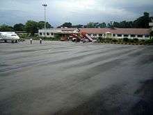
Silchar is one of the six cities of Assam to have an airport which is located at Kumbhirgram. The district is served by regular flights from Alliance Air, a subsidiary of Air India, SpiceJet and North East Shuttles. The district is connected by broad-gauge railroads to Lumding in Assam and by road to the rest of the country. Regular bus and train services are also there with other cities of North-East India.
Demographics
Population
| Historical population | ||
|---|---|---|
| Year | Pop. | ±% p.a. |
| 1901 | 301,884 | — |
| 1911 | 339,107 | +1.17% |
| 1921 | 359,376 | +0.58% |
| 1931 | 386,695 | +0.74% |
| 1941 | 437,284 | +1.24% |
| 1951 | 541,891 | +2.17% |
| 1961 | 664,351 | +2.06% |
| 1971 | 823,515 | +2.17% |
| 1991 | 1,215,385 | +1.97% |
| 2001 | 1,444,921 | +1.74% |
| 2011 | 1,736,617 | +1.86% |
| source:[12] | ||
According to the 2011 census, Cachar district has a population of 1,736,617,[13] roughly equal to the nation of The Gambia[14] or the US state of Nebraska.[15] This gives it a ranking of 278th in India out of a total of 640.[13] The district has a population density of 459 inhabitants per square kilometre (1,190/sq mi) .[13] Its population growth rate over the decade 2001-2011 was 20.17%.[13] Cachar has a sex ratio of 958 females for every 1000 males,[13] and a literacy rate of 80.36%.[13]
Religions
Religious demographics are as follows:[16]
- Hindus - 1,038,985
- Muslims - 654,816
- Christians - 37,635.
Languages
Bengali is the official language of the district and are spoken by 75% of the overall population, while English also served as 2nd additional official language of the district. Majority of the people primarily speak Sylheti (a dialect of Bengali). Other minority languages spoken in the district include Bhojpuri, Meitei Manipuri, Dimasa Kachari, Bishnupuriya Manipuri , Nepali Language, Hmar and Rongmei. There are also few Kuki, Khasi people who form microscopic minority.
Flora and fauna
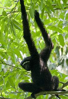
The vegetation is mostly Tropical evergreen and there are large tracts of Rainforests in the northern and southern parts of the district, which are home to Tiger, Asian elephants, hoolock gibbon, Gaur etc. The forests of Cachar were once rich in wildlife but now vanishing due to human onslaught. Rare species found are Hoolock gibbon, Phayre's leaf monkey, Pig-tailed macaque, Stump-tailed macaque, Masked Finfoot, White-winged Wood Duck etc., have been recorded. The Asian elephant is already extinct.[18][19] The southern part was also recommended as 'Dhaleswari' wildlife sanctuary.[20][21] Borail Wildlife Sanctuary is the only wildlife sanctuary of the district as well as Barak valley region. It was initiated by noted naturalist Dr. Anwaruddin Choudhury in early 1980s.[22] This sanctuary was ultimately notified in 2004.[23]
Education
The district of Cachar has a number of well-known educational institutes in North East India. Silchar, the district headquarter, is a major learning hub of Assam. The district has a central university, the Assam University, which is situated at Dorgakuna, 18 km from Silchar.[24] It also has NIT Silchar, one of the 30 NITs in India.[25] The Silchar Medical College and Hospital is the only medical college of southern Assam.[26] To ensure a steady flow of skilled workers in different trades for the industry Silchar Polytechnic, Meherpur and ITI, Srikona is there.
College
The district also includes a number of degree colleges such as:
- Cachar College
- Gurucharan College
- Radhamadhab College
- Ramanuj Gupta Memorial Junior College
- Janata College, Kabuganj
- Madhab Chandra Das College, Sonai
- Women's College, Silchar
- Aryan Junior College
- Sathya Ranjan college, Kalain
- Aviator Junior College, Kalain
- Katigorah Junior College
- Nehru College, Pailapool
- Jagannath Singh College, Udharbond
- Jagannath Singh Jr. College, Udhaarbond
School
Prominent schools in the district include:
- Saint Capitanio School
- Adhar Chand Higher Secondary School,
- Cachar High School,
- Don Bosco School,
- D.N.N.K. Girls' Higher Secondary School,
- Government Boys & Girls Schools,
- Oriental High School.
- Holy Cross School,
- Jawahar Navodaya Vidyalaya, Pailapool and
- Kendriya Vidyalayas,
- Maharishi Vidya Mandir,
- Muktashree High School,
- Narsing Higher Secondary School,
- Pranabananda Holy Child School
- Pranabananda Vidya Mandir
- Pranabananda Vidya Mandir (Malini Bill).
- Silchar Collegiate School,
- Sonai Nitya Gopal Higher Secondary School,
- Sonai Jubati Singha Manipuri High School,
- South Point School
- Oxford School
- Netaji Memorial Institute
- Murshedul Alam Choudhury Memorial Academy
- Adharsh Vidyapith, Kalain
- Jupiter High School, Kalain
- Asapalli English School, Fulertal
- Nehru Higher Secondary School, Pailapool
- D.N.H.S. School, Udharbond
- Saraswati Vidya Niketan, Kalain
- Swarna Lakshmi Higher Secondary School,Narshingpur
See also
References
- Sylheti language
- Chaudhuri Kalyan.(1999):New History of Assam & IndiaGuwahati: Oriental Book Company.
- Bhattacharjee, J. B. (1977). Cachar under British Rule in North East India. Radiant Publishers, New Delhi.
- Barua, D. C. (1990). Moulvi Matlib Mazumdar- as I knew him. Abdul Matlib Mazumdar – birth centenary tributes, pp. 8–9.
- Purkayashta, M. (1990). Tyagi jananeta Abdul Matlib Mazumdar. The Prantiya Samachar (in Bengali). Silchar, India.
- Roy, S. K. (1990). Jananeta Abdul Matlib Mazumdar (in Bengali). Abdul Matlib Mazumdar – birth centenary tributes, pp. 24–27.
- Srivastava, Dayawanti et al. (ed.) (2010). "States and Union Territories: Assam: Government". India 2010: A Reference Annual (54th ed.). New Delhi, India: Additional Director General, Publications Division, Ministry of Information and Broadcasting (India), Government of India. p. 1116. ISBN 978-81-230-1617-7.CS1 maint: extra text: authors list (link)
- "Island Directory Tables: Islands by Land Area". United Nations Environment Program. 18 February 1998. Retrieved 11 October 2011.
South Georgia 3,718
- Ministry of Panchayati Raj (8 September 2009). "A Note on the Backward Regions Grant Fund Programme" (PDF). National Institute of Rural Development. Archived from the original (PDF) on 5 April 2012. Retrieved 27 September 2011.
- "List of Assembly Constituencies showing their Revenue & Election District wise break - up" (PDF). Chief Electoral Officer, Assam website. Archived from the original (PDF) on 22 March 2012. Retrieved 26 September 2011.
- "List of Assembly Constituencies showing their Parliamentary Constituencies wise break - up" (PDF). Chief Electoral Officer, Assam website. Archived from the original (PDF) on 22 March 2012. Retrieved 26 September 2011.
- Decadal Variation In Population Since 1901
- "District Census 2011". Census2011.co.in. 2011. Retrieved 30 September 2011.
- US Directorate of Intelligence. "Country Comparison:Population". Retrieved 1 October 2011.
Gambia, The 1,797,860 July 2011 est.
- "2010 Resident Population Data". U.S. Census Bureau. Archived from the original on 1 January 2011. Retrieved 30 September 2011.
Nebraska 1,826,341
- "Religious demography of Assam Census 2011". Retrieved 26 February 2018.
- "Religious demography of Assam Census 2011". Retrieved 26 February 2018.
- Choudhury, A.U. (1999). Status and Conservation of the Asian elephant Elephas maximus in north-eastern India. Mammal Review 29(3): 141–173.
- Choudhury, A.U. (2004). Vanishing habitat threatens Phayre’s leaf monkey. The Rhino Found. NE India Newsletter 6:32–33.
- Choudhury, A.U. (1983). Plea for a new wildlife refuge in eastern India. Tigerpaper 10(4):12-15.
- Choudhury, A.U. (1983). Plea for a new wildlife sanctuary in Assam. WWF - India Newsletter 4(4):15.
- Choudhury, A.U. (1989). Campaign for wildlife protection:national park in the Barails. WWF-Quarterly No. 69,10(2): 4–5.
- Choudhury, A.U. (2005). Amchang, Barail and Dihing-Patkai – Assam’s new wildlife sanctuaries. Oryx 39(2): 124–125.
- Assam University, Official website
- Official NIT, Silchar website
- Official website of Silchar Medical College
External links
| Wikimedia Commons has media related to Cachar district. |
Places adjacent to Cachar district | |
|---|---|