Bandera, Texas
Bandera (Spanish: "flag", /bænˈdɛrə/ ban-DERR-ə) is the county seat of Bandera County, Texas, United States, in the Texas Hill Country, which is part of the Edwards Plateau.[5] The population was 857 at the 2010 census.[6] It is part of the San Antonio Metropolitan Statistical Area.
Bandera, Texas | |
|---|---|
City | |
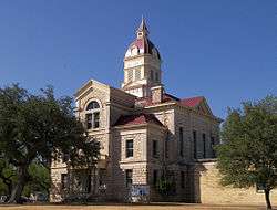 Bandera County Courthouse | |
| Nickname(s): "Cowboy Capital of the World" | |
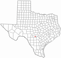 Location of Bandera, Texas | |
 | |
 Bandera, Texas Location in the United States | |
| Coordinates: 29°43′30″N 99°4′20″W | |
| Country | United States |
| State | Texas |
| County | Bandera |
| Government | |
| • Mayor | Suzanne Schauman |
| Area | |
| • Total | 1.16 sq mi (3.00 km2) |
| • Land | 1.16 sq mi (3.00 km2) |
| • Water | 0.00 sq mi (0.01 km2) |
| Elevation | 1,243 ft (379 m) |
| Population (2010) | |
| • Total | 857 |
| • Estimate (2019)[2] | 900 |
| • Density | 778.55/sq mi (300.49/km2) |
| Time zone | UTC-6 (Central (CST)) |
| • Summer (DST) | UTC-5 (CDT) |
| ZIP code | 78003 |
| Area code(s) | 830 |
| FIPS code | 48-05528[3] |
| GNIS feature ID | 1330000[4] |
| Website | www |
Bandera calls itself the "Cowboy Capital of the World". The Frontier Times Museum, founded by J. Marvin Hunter and named for Hunter's Frontier Times magazine, is located in Bandera across from the First Baptist Church.
History
A visitor to Bandera can see a sign on Main Street, in front of the fire department, which states that Bandera was founded by Polish Roman Catholic immigrants from Upper Silesia. St. Stanislaus Catholic Church was built by those immigrants, and the church is one of the oldest in Texas. Many of the residents are descended from those original Polish immigrants.
Several stories exist regarding the origin of the name "Bandera". One says that in the 19th century, a flag was placed at the top of a path that came to be called Bandera Pass, due to bandera being the Spanish and Polish word for flag.
Bandera was the starting point of the Great Western Cattle Trail, during the second half of the 19th century.
Geography
Bandera is located in east-central Bandera County at 29°44′N 99°4′W (29.7258, −99.0750).[7] It is 47 miles (76 km) northwest of downtown San Antonio, on the Medina River.
According to the United States Census Bureau, the city has a total area of 1.2 square miles (3.1 km2), of which 0.008 square miles (0.02 km2), or 0.55%, is water.[6]
Demographics
| Historical population | |||
|---|---|---|---|
| Census | Pop. | %± | |
| 1890 | 372 | — | |
| 1900 | 419 | 12.6% | |
| 1920 | 700 | — | |
| 1930 | 580 | −17.1% | |
| 1940 | 1,250 | 115.5% | |
| 1950 | 1,325 | 6.0% | |
| 1960 | 1,065 | −19.6% | |
| 1970 | 891 | −16.3% | |
| 1980 | 947 | 6.3% | |
| 1990 | 877 | −7.4% | |
| 2000 | 957 | 9.1% | |
| 2010 | 857 | −10.4% | |
| Est. 2019 | 900 | [2] | 5.0% |
| U.S. Decennial Census[8] | |||
As of the census of 2000, there were 957 people, 408 households, and 239 families residing in the city. The population density was 820.2 inhabitants per square mile (316.7/km2). There were 488 housing units at an average density of 418.2 per square mile (161.5/km2). The racial makeup of the city was 94.98% White, 0.21% African American, 0.52% Native American, 2.51% from other races, and 1.78% from two or more races. Hispanic or Latino of any race were 21.84% of the population.
There were 408 households, out of which 24.5% had children under the age of 18 living with them, 43.4% were married couples living together, 11.3% had a female householder with no husband present, and 41.4% were non-families. 34.1% of all households were made up of individuals, and 16.2% had someone living alone who was 65 years of age or older. The average household size was 2.22 and the average family size was 2.86.
In the city, the population was spread out, with 21.5% under the age of 18, 6.7% from 18 to 24, 23.5% from 25 to 44, 23.2% from 45 to 64, and 25.1% who were 65 years of age or older. The median age was 44 years. For every 100 females, there were 83.3 males. For every 100 females age 18 and over, there were 82.3 males.
The median income for a household in the city was $31,089, and the median income for a family was $36,500. Males had a median income of $27,604 versus $17,813 for females. The per capita income for the city was $16,502. About 11.0% of families and 15.3% of the population were below the poverty line, including 18.0% of those under age 18 and 17.1% of those age 65 or over.
Education
Bandera is served by the Bandera Independent School District and home to the Bandera High School Bulldogs.
Entertainment
- Bandera is featured in the 1980 CBS unsold pilot Jake's Way which starred Robert Fuller, Michael Jaymes, Andrew Duggan, the late Slim Pickens, and newcomers Lisa LeMole, Stephen McNaughton (credited as Steven McNaughton) and Ben Lemon and was produced by Disney Television Studios and Barry & Enright Production.
- The city is home of Arkey Blue's Silver Dollar, a famous Hill Country honky-tonk, and was included in the 1975 horror film, Race with the Devil.[9]
- On Sunday mornings, Bandera is a popular destination for motorcyclists from San Antonio, known as the Bandera Breakfast Run.
- Bandera is home to the Bandera Riverfest that takes place in June each year on the Medina River, offering tubing, kayaking, cookoffs, and live music throughout the weekend.
- Willie Nelson has an instrumental called "Bandera" on his Red Headed Stranger record.
- "The Bandera Waltz" was written by Easy Adams in 1949, and has been recorded by the Texas Top Hands, Slim Whitman, and Bruce Robison.
- Bandera was once home to singer-songwriter Robert Earl Keen
- Bandera is the hometown of singer-songwriter brothers Bruce Robison and Charlie Robison.
- The rugged Hill Country State Natural Area is the location of the Bandera 100K trail run and the Cactus Rose 100-mile endurance run, two of the toughest ultramarathons in Texas. Both are hosted annually by race director and veteran trail runner Joe Prusaitis.
- The Bandera Downs horse racing facility lies just northeast of town. It is now closed.
- The Mayan Dude Ranch and the Dixie Dude Ranch are both over 50 years old and are located in Bandera.
- Rudy Robbins (born 1933), a Western actor, stuntman, singer, and songwriter, lived in Bandera for nearly five decades until his death in 2011.
Sister cities
Gallery
 The First Baptist Church of Bandera is across from the Frontier Times Museum
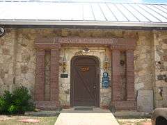 Entrance to the Frontier Times Museum in Bandera
 Outdoor mural reflects the theme of Bandera as the "Cowboy Capital of the World"
 Motorcyclists in Bandera
References
- "2019 U.S. Gazetteer Files". United States Census Bureau. Retrieved June 26, 2020.
- "Population and Housing Unit Estimates". United States Census Bureau. May 24, 2020. Retrieved May 27, 2020.
- "U.S. Census website". United States Census Bureau. Retrieved January 31, 2008.
- "US Board on Geographic Names". United States Geological Survey. October 25, 2007. Retrieved January 31, 2008.
- "Find a County". National Association of Counties. Archived from the original on May 31, 2011. Retrieved June 7, 2011.
- "Geographic Identifiers: 2010 Demographic Profile Data (G001): Bandera city, Texas". U.S. Census Bureau, American Factfinder. Archived from the original on February 12, 2020. Retrieved April 9, 2014.
- "US Gazetteer files: 2010, 2000, and 1990". United States Census Bureau. February 12, 2011. Retrieved April 23, 2011.
- "Census of Population and Housing". Census.gov. Retrieved June 4, 2015.
- "Honky Tonk Texas, USA". Archived from the original on December 12, 2007. Retrieved December 6, 2007.
- "Interactive City Directory". Sister Cities International. Archived from the original on March 1, 2016. Retrieved February 20, 2016.
External links
- City of Bandera official website
- Bandera Chamber of Commerce
- Bandera Visitors Bureau
- Bandera from the Handbook of Texas Online
- Bandera, Texas at Curlie
Municipalities and communities of Bandera County, Texas, United States | ||
|---|---|---|
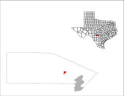
| City | 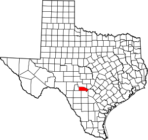 Bandera County map | |
| CDPs | ||
| Other unincorporated communities | ||
| Footnotes | ‡This city also has portions in an adjacent county or counties | |

| Authority control |
|
|---|