Monahans, Texas
Monahans is a city in and the county seat of Ward County, Texas, United States.[3] A very small portion of the city extends into Winkler County. The population was 6,953 at the 2010 census. In 2018 the population stood at 7,669.
Monahans, Texas | |
|---|---|
 Air photo of part of Monahans facing northeast in 2012 | |
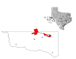 Location of Monahans, Texas | |
| Coordinates: 31°35′16″N 102°53′26″W | |
| Country | |
| State | |
| Counties | Ward, Winkler |
| Government | |
| • Mayor | David Cutbirth |
| Area | |
| • Total | 24.8 sq mi (64 km2) |
| • Land | 24.8 sq mi (64 km2) |
| • Water | 0.0 sq mi (0 km2) |
| Elevation | 2,621 ft (799 m) |
| Population (2010) | |
| • Total | 6,953 |
| • Estimate (2018) | 7,669 |
| • Density | 280/sq mi (110/km2) |
| Time zone | UTC-6 (Central (CST)) |
| • Summer (DST) | UTC-5 (CDT) |
| ZIP code | 79756 |
| Area code(s) | 432 |
| FIPS code | 48-48936[1] |
| GNIS feature ID | 1363045[2] |
| Website | www.cityofmonahans.org |
History
The Permian Basin, home to Monahans and Midland/Odessa MSA, is 250 miles (400 km) wide and 300 miles (480 km) long - Monahans is "The Center of the Permian Basin". The basin was formed during the Permian Period, the final portion of the Paleozoic Era. At the time, it was an ocean filled with abundant aquatic life.
In 1583, a Spanish explorer named Antonio de Espejo crossed this area on his way through present-day New Mexico. The Indians in the Monahans region were called "Vaqueros" by these Spanish explorers because they hunted the "hump-backed cow" or bison. Records of Spanish exploring the Los Medanos (the sand dunes) outside Monahans can be traced to the early 1770s.
Located in a region where native Comanches, Mescalero, and Lipan Apache Indians once roamed, Monahans' history as a community extends back to the late 1880s with the expansion of the Texas and Pacific Railway across the south plains. For the few people living in West Texas, the building of a transcontinental railroad through the area meant the arrival of civilization. In the summer of 1881, Texas and Pacific Railroad contracted with surveyor John Thomas Monahan, who discovered that the lack of water for the laying crew and their animals would slow down construction of the rail. Monahans' digging of a water well produced an abundance of good water (250,000 US gallons (950,000 L) a day) and was instrumental in the success of the city. Prior to this solution, water had to be hauled from the area of Big Spring, Texas.
The availability of cheap land encouraged settlers to form a small community on the track known as Monahans Well. However, when oil was discovered in the area in 1926, the trajectory of the community changed directions. Oil discovery brought people of many occupations and of varied interests to Monahans. The local economy began to change from an agricultural to an industrial economy,
Monahans Sandhills State Park
Thousands of tourists each year visit Monahans Sandhills State Park near Monahans. Sand surfing and sand football games can be seen year round, but particularly between March and November. Monahans Sandhills State Park is host to many family picnics and youth activities. The park is also a site for weddings.
Geography
Climate
| Climate data for Monahans, Texas (1981–2010) | |||||||||||||
|---|---|---|---|---|---|---|---|---|---|---|---|---|---|
| Month | Jan | Feb | Mar | Apr | May | Jun | Jul | Aug | Sep | Oct | Nov | Dec | Year |
| Record high °F (°C) | 87 (31) |
91 (33) |
100 (38) |
106 (41) |
114 (46) |
120 (49) |
115 (46) |
110 (43) |
108 (42) |
104 (40) |
92 (33) |
86 (30) |
120 (49) |
| Average high °F (°C) | 61.8 (16.6) |
66.5 (19.2) |
74.4 (23.6) |
83.4 (28.6) |
91.5 (33.1) |
97.5 (36.4) |
98.6 (37.0) |
97.0 (36.1) |
91.1 (32.8) |
82.5 (28.1) |
70.7 (21.5) |
61.8 (16.6) |
81.4 (27.4) |
| Average low °F (°C) | 28.6 (−1.9) |
33.0 (0.6) |
39.5 (4.2) |
48.2 (9.0) |
58.0 (14.4) |
67.0 (19.4) |
69.2 (20.7) |
68.5 (20.3) |
61.7 (16.5) |
50.5 (10.3) |
37.7 (3.2) |
29.1 (−1.6) |
49.3 (9.6) |
| Record low °F (°C) | −9 (−23) |
−8 (−22) |
12 (−11) |
25 (−4) |
35 (2) |
45 (7) |
50 (10) |
50 (10) |
33 (1) |
22 (−6) |
10 (−12) |
5 (−15) |
−9 (−23) |
| Average precipitation inches (mm) | 0.54 (14) |
0.71 (18) |
0.53 (13) |
0.57 (14) |
1.60 (41) |
1.35 (34) |
1.61 (41) |
1.73 (44) |
2.03 (52) |
1.63 (41) |
0.58 (15) |
0.67 (17) |
13.54 (344) |
| Average snowfall inches (cm) | 0.2 (0.51) |
0.0 (0.0) |
0.1 (0.25) |
0.0 (0.0) |
0.0 (0.0) |
0.0 (0.0) |
0.0 (0.0) |
0.0 (0.0) |
0.0 (0.0) |
0.0 (0.0) |
0.1 (0.25) |
0.3 (0.76) |
0.8 (2.0) |
| Source: NOAA[4] | |||||||||||||
Demographics
| Historical population | |||
|---|---|---|---|
| Census | Pop. | %± | |
| 1930 | 816 | — | |
| 1940 | 3,944 | 383.3% | |
| 1950 | 6,311 | 60.0% | |
| 1960 | 8,567 | 35.7% | |
| 1970 | 8,333 | −2.7% | |
| 1980 | 8,397 | 0.8% | |
| 1990 | 8,101 | −3.5% | |
| 2000 | 6,821 | −15.8% | |
| 2010 | 6,953 | 1.9% | |
| Est. 2018 | 7,669 | [5] | 10.3% |
| 1930-2000,[6] 2010[7] | |||
As of the census[1] of 2000, there were 6,821 people, 2,496 households, and 1,837 families residing in the city. The population density was 274.9 people per square mile (106.2/km2). There were 3,015 housing units at an average density of 121.5 per square mile (46.9/km2). The racial makeup of the city was 79.30% White, 5.16% African American, 0.35% Native American, 0.35% Asian, 0.04% Pacific Islander, 12.51% from other races, and 2.29% from two or more races. Hispanic or Latino of any race were 43.66% of the population.
There were 2,496 households out of which 38.3% had children under the age of 18 living with them, 56.4% were married couples living together, 13.5% had a female householder with no husband present, and 26.4% were non-families. 24.3% of all households were made up of individuals and 12.7% had someone living alone who was 65 years of age or older. The average household size was 2.68 and the average family size was 3.19.
In the city, the population was spread out with 30.3% under the age of 18, 8.2% from 18 to 24, 25.7% from 25 to 44, 21.5% from 45 to 64, and 14.3% who were 65 years of age or older. The median age was 36 years. For every 100 females, there were 93.1 males. For every 100 females age 18 and over, there were 89.4 males.
The median income for a household in the city was $30,349, and the median income for a family was $36,726. Males had a median income of $31,307 versus $18,086 for females. The per capita income for the city was $14,100. About 14.7% of families and 16.5% of the population were below the poverty line, including 17.1% of those under age 18 and 18.1% of those age 65 or over.
In December 2015, the Seattle Post-Intelligencer voted Monahans No. 5 among the ten "most conservative" cities in the United States in regard to campaign contributions. Other West Texas communities in the most conservative lineup are Hereford (No. 1), Dalhart (No. 5), and Childress (No. 9). Princeton in Collin County north of Dallas ranked No. 2.[8]
Government and infrastructure
The Texas Department of Criminal Justice operates the Monahans District Parole Office in Monahans.[9]
The United States Postal Service operates the Monahans Post Office.[10]
Education
Public education in the city of Monahans is provided by the Monahans-Wickett-Pyote Independent School District.
Notable people
- Carter Casteel, lawyer and Republican politician from New Braunfels; born in Monahans in 1942
- Dale Dudley, Texas Radio Hall of Fame member; host of Dudley and Bob Morning Show on KLBJ FM in Austin; spent part of his childhood in Monahans
- Guy Clark, songwriter and country musician; city is mentioned in his songs as well as in 1997 live album Keepers during a musical interlude
- Kathy Whitworth, professional golfer in Texas Sports Hall of Fame and World Golf Hall of Fame
- Natalie Zea (born March 17, 1975), actress, starred in television series Justified
- Deanna Dunagan is a Tony Award winning actress who has made a prolific career acting on the Chicago stage. Originally from Monahans, TX. Dunagan made her Broadway debut in the 1979 production of George Bernard Shaws "Man and Superman" at the Circle In the Square. She has also starred in many movies and TV series. You might know her as Nana on M. Night Shyamalans 2015 movie The Visit. She has also appeared on TV shows such as Psych, Prison Break, Law and Order and many more.
Transportation
The Texas-New Mexico Railroad operates a 111-mile (179 km) branch line from a connection with the Union Pacific at Monahans. The branch line was constructed between 1928 and 1930 and terminates at Lovington, New Mexico.
References
- "U.S. Census website". United States Census Bureau. Retrieved 2008-01-31.
- "US Board on Geographic Names". United States Geological Survey. 2007-10-25. Retrieved 2008-01-31.
- "Find a County". National Association of Counties. Retrieved 2011-06-07.
- "NOWData - NOAA Online Weather Data". National Oceanic and Atmospheric Administration. Retrieved May 6, 2013.
- https://www.census.gov/quickfacts/fact/table/easthillsvillagenewyork/PST045218
- Texasalmanac (PDF-Datei; 1,13 MB). Retrieved 2013-08-01
- U.S. Census Archived 2013-07-08 at the Wayback Machine. Retrieved 2013-08-01
- Daniel DeMay (December 17, 2015). "The most liberal and most conservative cities in the US". The Connecticut Post. Bridgeport, Connecticut. Retrieved December 20, 2015.
- "DIRECTORY - REGIONAL AND DISTRICT PAROLE OFFICES REGION V Archived 2010-01-25 at the Wayback Machine." Texas Department of Criminal Justice. Retrieved on July 28, 2010.
- "Post Office Location - MONAHANS Archived 2011-07-16 at the Wayback Machine." United States Postal Service. Retrieved on July 28, 2010.
External links
Municipalities and communities of Ward County, Texas, United States | ||
|---|---|---|
| Cities |  Ward County map | |
| Towns | ||
| Unincorporated community | ||
| Footnotes | ‡ This populated place also has portions in an adjacent county or counties | |
Municipalities and communities of Winkler County, Texas, United States | ||
|---|---|---|
| Cities |  Winkler County map | |
| Footnotes | ‡This populated place also has portions in an adjacent county or counties | |

| Authority control |
|
|---|