Baird, Texas
Baird is a city and the county seat of Callahan County,[5] Texas, United States. The population was 1,496 at the 2010 census.[6] The city is named after Matthew Baird, the owner and director of the Texas & Pacific Railway. The railway depot is now operated as the visitor center and a transportation museum.[7]
Baird, Texas | |
|---|---|
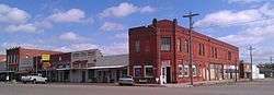 Baird Main Street | |
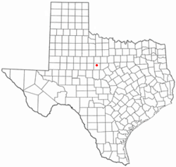 Location of Baird, Texas | |
 | |
| Coordinates: 32°23′46″N 99°23′50″W | |
| Country | United States |
| State | Texas |
| County | Callahan |
| Area | |
| • Total | 2.73 sq mi (7.06 km2) |
| • Land | 2.66 sq mi (6.88 km2) |
| • Water | 0.07 sq mi (0.18 km2) |
| Elevation | 1,722 ft (525 m) |
| Population (2010) | |
| • Total | 1,496 |
| • Estimate (2019)[2] | 1,486 |
| • Density | 559.28/sq mi (215.97/km2) |
| Time zone | UTC-6 (Central (CST)) |
| • Summer (DST) | UTC-5 (CDT) |
| ZIP code | 79504 |
| Area code(s) | 325 |
| FIPS code | 48-05336[3] |
| GNIS feature ID | 1372371[4] |


Baird is part of the Abilene, Texas Metropolitan Statistical Area.
Geography
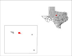
Baird is located in north-central Callahan County at 32°23′46″N 99°23′50″W (32.396035, -99.397140).[8] Interstate 20 passes through the northern part of the city, leading west 20 miles (32 km) to Abilene and east 25 miles (40 km) to Cisco. U.S. Route 283 crosses the east side of town, leading north 25 miles (40 km) to Albany and south 41 miles (66 km) to Coleman.
According to the United States Census Bureau, the city has a total area of 2.7 square miles (7.1 km2), of which 2.7 square miles (6.9 km2) is land and 0.1 square miles (0.2 km2), or 2.55%, is water.[6]
History
Baird, Texas was named after Matthew Baird, a director of the Texas and Pacific Railway. He was also sole proprietor of the Baldwin Locomotive Works, the largest locomotive firm in the United States, headquartered in Philadelphia, Pennsylvania.
The city was officially founded in 1880. In 1993, the Texas Legislature designated Baird as the "Antique Capital of West Texas". It has twelve antique shops.
Library
The Callahan County Library was started in 1937 by the Baird Wednesday Club. The Pioneer Museum was added in 1940. Both are located on the basement floor of the Callahan County Courthouse. The museum features farm and ranch implements, household items, clothing, barbed wire, and documents.
Demographics
| Historical population | |||
|---|---|---|---|
| Census | Pop. | %± | |
| 1890 | 850 | — | |
| 1900 | 1,502 | 76.7% | |
| 1910 | 1,710 | 13.8% | |
| 1920 | 1,902 | 11.2% | |
| 1930 | 1,965 | 3.3% | |
| 1940 | 1,810 | −7.9% | |
| 1950 | 1,821 | 0.6% | |
| 1960 | 1,633 | −10.3% | |
| 1970 | 1,538 | −5.8% | |
| 1980 | 1,696 | 10.3% | |
| 1990 | 1,658 | −2.2% | |
| 2000 | 1,623 | −2.1% | |
| 2010 | 1,496 | −7.8% | |
| Est. 2019 | 1,486 | [2] | −0.7% |
| U.S. Decennial Census[9] | |||
As of the census[3] of 2000, there were 1,623 people, 677 households, and 429 families residing in the city. The population density was 619.0 people per square mile (239.2/km2). There were 806 housing units at an average density of 307.4 per square mile (118.8/km2). The racial makeup of the city was 90.51% White, 0.18% African American, 0.31% Native American, 0.74% Asian, 0.06% Pacific Islander, 7.09% from other races, and 1.11% from two or more races. Hispanic or Latino of any race were 13.43% of the population.
There were 677 households, out of which 28.4% had children under the age of 18 living with them, 49.6% were married couples living together, 9.3% had a female householder with no husband present, and 36.6% were non-families. 33.7% of all households were made up of individuals, and 19.8% had someone living alone who was 65 years of age or older. The average household size was 2.32 and the average family size was 2.96.
In the city, the population was spread out, with 23.4% under the age of 18, 7.3% from 18 to 24, 24.6% from 25 to 44, 24.0% from 45 to 64, and 20.8% who were 65 years of age or older. The median age was 41 years. For every 100 females, there were 93.0 males. For every 100 females age 18 and over, there were 88.9 males.
The median income for a household in the city was $27,446, and the median income for a family was $35,000. Males had a median income of $21,974 versus $16,298 for females. The per capita income for the city was $13,951. About 12.3% of families and 14.0% of the population were below the poverty line, including 18.4% of those under age 18 and 12.5% of those age 65 or over.
Education
The City of Baird is served by the Baird Independent School District, located at 600 West 7th Street. Baird ISD is classified as a 2A high school.
Interesting facts
- On June 22, 1993 the town was christened by the state legislature as the "Antique Capital of West Texas".
- The town has five churches, four gas stations, a feed store, and a small locally owned grocery store. Franchises here include a Dairy Queen, Love's truck stop, and a Dollar General. The truck stop has a Subway and a Chester's Chicken.
- The former Callahan County Jail, at 100 W. 5th Street, was originally located in nearby Belle Plain, then the county seat. When the county seat moved to Baird, the jail was disassembled brick by brick, and reassembled at its current location. Belle Plain lost population and became a ghost town.
- Texas author Lou Halsell Rodenberger (1926–2009) lived much of her later years 12 miles (19 km) southeast of Baird, in the small community of Admiral.
Climate
The climate in this area is characterized by hot, humid summers and generally mild to cool winters. According to the Köppen Climate Classification system, Baird has a humid subtropical climate, abbreviated "Cfa" on climate maps.[10]
References
- "2019 U.S. Gazetteer Files". United States Census Bureau. Retrieved June 26, 2020.
- "Population and Housing Unit Estimates". United States Census Bureau. May 24, 2020. Retrieved May 27, 2020.
- "U.S. Census website". United States Census Bureau. Retrieved 2008-01-31.
- "US Board on Geographic Names". United States Geological Survey. 2007-10-25. Retrieved 2008-01-31.
- "Find a County". National Association of Counties. Archived from the original on 2011-05-31. Retrieved 2011-06-07.
- "Geographic Identifiers: 2010 Census Summary File 1 (G001): Baird city, Texas". U.S. Census Bureau, American Factfinder. Archived from the original on February 13, 2020. Retrieved July 8, 2015.
- "US Gazetteer files: 2010, 2000, and 1990". United States Census Bureau. 2011-02-12. Retrieved 2011-04-23.
- "Census of Population and Housing". Census.gov. Retrieved June 4, 2015.
- Climate Summary for Baird, Texas
External links
| Wikimedia Commons has media related to Baird, Texas. |
Municipalities and communities of Callahan County, Texas, United States | ||
|---|---|---|
| Cities |  Callahan County map | |
| Towns | ||
| Unincorporated communities | ||
| Ghost towns | ||
