Dalhart, Texas
Dalhart is a city in Dallam and Hartley Counties in the U.S. state of Texas, and the county seat of Dallam County.[4] The population was 7,930 at the 2010 census.[5]
Dalhart, Texas | |
|---|---|
 Dalhart Consumers grain elevator, 2008 | |
| Motto(s): "The XIT City"[1] | |
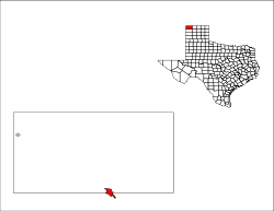 Location within Dallam County and Texas | |
| Coordinates: 36°3′39″N 102°31′7″W | |
| Country | United States |
| State | Texas |
| Counties | Dallam, Hartley |
| Area | |
| • Total | 4.79 sq mi (12.41 km2) |
| • Land | 4.78 sq mi (12.38 km2) |
| • Water | 0.01 sq mi (0.03 km2) |
| Elevation | 3,983 ft (1,214 m) |
| Population (2010) | |
| • Total | 7,930 |
| • Density | 1,700/sq mi (640/km2) |
| Time zone | UTC-6 (Central (CST)) |
| • Summer (DST) | UTC-5 (CDT) |
| ZIP code | 79022 |
| Area code | 806 |
| FIPS code | 48-18524 [2] |
| GNIS feature ID | 1355552 [3] |
| Website | dalharttx.gov |
History
.jpg)
Founded in 1901, Dalhart is named for its location on the border of Dallam and Hartley Counties; its name is a portmanteau of the names of the two counties.[6][7] The city was founded at the site of a railroad junction, which heavily contributed to its early growth.
Dalhart was in the center of the Dust Bowl, an area adversely affected by a long period of drought and dust storms during the Great Depression of the 1930s. Here, Tex Thornton, operating on the now debunked concussion theory, coaxed today's inflation-adjusted equivalent of $1 million from the locals on claims he could fire rocket-powered explosives into the clouds and cause rain.[8]
At the Dallam County Courthouse, Dalhart honors the memory of James R. Fox, Jr. (March 16, 1919—March 11, 1943), who flew supplies to China for Pan American Airways, then a joint Chinese and American company, during World War II through the treacherous Hump Route. Fox and his two Chinese copilots were killed when their Douglas C-52 cargo plane crashed. In 2002, the People's Republic of China made a bronze bust in Fox's honor and presented it to Dalhart.[9]
Geography
Dalhart is located in northwestern Texas at 36°3′39″N 102°31′7″W (36.060856, −102.518656).[10] According to the United States Census Bureau, the city has a total area of 4.8 square miles (12.4 km2), of which 0.01 square miles (0.03 km2), or 0.21%, is covered by water.[5] Dalhart sits in the Southern Great Plains and is heavily impacted by its agriculture industry. Dalhart is about 70 miles northwest of Amarillo, the nearest city that has a population over 100,000.
Dalhart sits at the intersection of U.S. Highway 87, 385, and 54. Two miles south of Dalhart is Rita Blanca Canyon, site of Rita Blanca Lake State Park.
Dalhart is located closer to six other state capitals than to Texas' capital of Austin. In surface mileage (over major highways), Dalhart is 570 miles (920 km) from Austin,[11] but is 261 miles (420 km) from Santa Fe, New Mexico,[12] 313 miles (504 km) from Oklahoma City, Oklahoma,[13] 348 miles (560 km) from Denver, Colorado,[14] 448 miles (721 km) from Cheyenne, Wyoming,[15] 461 miles (742 km) from Topeka, Kansas,[16] and 544 miles (875 km) from Lincoln, Nebraska.[17]
As the "crow flies", Dalhart is 491 miles (790 km) from Austin, but 201 miles (323 km) from Santa Fe, 281 miles (452 km) from Oklahoma City, 289 miles (465 km) from Denver, 375 miles (604 km) from Cheyenne, 434 miles (698 km) from Topeka, and 458 miles (737 km) from Lincoln.[18]
Climate
Dalhart experiences a semiarid climate (Köppen BSk) with cool, dry winters and hot summers. The average annual rainfall of less than 17 inches or 430 millimetres strongly influences both Dalhart's ecological climate and agricultural practices, especially center-pivot irrigation.[19]
Since records began in 1948, the hottest temperature in Dalhart has been 110 °F (43.3 °C) on June 26, 2011, and the coldest −21 °F (−29.4 °C) on January 4, 1959. On average, 65 afternoons each year will reach or top 90 °F or 32.2 °C, 133.8 mornings will fall to or below freezing, 10.1 afternoons will fail to top freezing, and two mornings will fall to or below 0 °F (−17.8 °C). The hottest complete month has been July 2011 with a mean maximum of 99.81 °F or 37.7 °C and the coldest January 1963 with a mean minimum of 7.55 °F or −13.6 °C. The wettest calendar year has been 1985 with 28.03 inches (712.0 mm) and the driest 2011 with only 6.04 inches (153.4 mm).
| Climate data for Dalhart, Texas (1948-2013) | |||||||||||||
|---|---|---|---|---|---|---|---|---|---|---|---|---|---|
| Month | Jan | Feb | Mar | Apr | May | Jun | Jul | Aug | Sep | Oct | Nov | Dec | Year |
| Record high °F (°C) | 82 (28) |
88 (31) |
90 (32) |
96 (36) |
102 (39) |
110 (43) |
107 (42) |
106 (41) |
103 (39) |
96 (36) |
89 (32) |
82 (28) |
110 (43) |
| Average high °F (°C) | 49.6 (9.8) |
53.2 (11.8) |
61.0 (16.1) |
70.1 (21.2) |
78.7 (25.9) |
88.1 (31.2) |
91.5 (33.1) |
89.3 (31.8) |
82.1 (27.8) |
71.8 (22.1) |
59.1 (15.1) |
50.3 (10.2) |
70.4 (21.3) |
| Average low °F (°C) | 19.5 (−6.9) |
23.2 (−4.9) |
29.4 (−1.4) |
38.8 (3.8) |
49.0 (9.4) |
58.8 (14.9) |
63.4 (17.4) |
62.0 (16.7) |
53.7 (12.1) |
41.2 (5.1) |
28.7 (−1.8) |
21.1 (−6.1) |
40.7 (4.8) |
| Record low °F (°C) | −21 (−29) |
−19 (−28) |
0 (−18) |
16 (−9) |
25 (−4) |
37 (3) |
49 (9) |
48 (9) |
27 (−3) |
9 (−13) |
−5 (−21) |
−12 (−24) |
−21 (−29) |
| Average precipitation inches (mm) | 0.45 (11) |
0.42 (11) |
0.91 (23) |
1.13 (29) |
2.37 (60) |
2.23 (57) |
2.94 (75) |
2.60 (66) |
1.49 (38) |
1.25 (32) |
0.55 (14) |
0.48 (12) |
16.82 (427) |
| Average snowfall inches (cm) | 3.7 (9.4) |
3.3 (8.4) |
3.0 (7.6) |
0.8 (2.0) |
0.2 (0.51) |
0.0 (0.0) |
0.0 (0.0) |
0.0 (0.0) |
0.0 (0.0) |
0.4 (1.0) |
1.8 (4.6) |
3.3 (8.4) |
16.6 (42) |
| Average precipitation days (≥ 0.01 inch) | 3 | 3 | 4 | 5 | 7 | 7 | 8 | 8 | 6 | 4 | 3 | 3 | 63 |
| Source: The Western Regional Climate Center[20] | |||||||||||||
Demographics
| Historical population | |||
|---|---|---|---|
| Census | Pop. | %± | |
| 1910 | 2,580 | — | |
| 1920 | 2,676 | 3.7% | |
| 1930 | 4,691 | 75.3% | |
| 1940 | 4,682 | −0.2% | |
| 1950 | 5,918 | 26.4% | |
| 1960 | 5,160 | −12.8% | |
| 1970 | 5,705 | 10.6% | |
| 1980 | 6,854 | 20.1% | |
| 1990 | 6,246 | −8.9% | |
| 2000 | 7,237 | 15.9% | |
| 2010 | 7,930 | 9.6% | |
| U.S. Decennial Census[21] | |||
In December 2015, the Seattle Post-Intelligencer voted Dalhart number eight of the 10 "most conservative" cities in the United States in regard to campaign contributions. Other West Texas communities in the most conservative lineup are Hereford (number one), Monahans (number five), and Childress (number nine). In contrast, El Cerrito, California, was named the "most liberal" city in the nation regarding political donations.[22]
2010 Census
As of the 2010 Census, Dalhart had a population of 7,930 living in 2,957 housing locations; 50.3% of the population was male, with 49.7% being female. The census revealed that 28.9% of the population was under the age of 18, while 12.4% of citizens were over the age of 65. With an area of 4.78 square miles, the City of Dalhart has a population density of 1659.0 persons/square mile.[23]
Census data showed that 84.0% of the population identified as White, while 1.2% identified as Black/African American, 0.7% identified as Asian, 0.9% identified as Native American, and 0.1% were Pacific Islander. About 10.5% of the remaining population identified themselves as some other race, while 2.5% considered themselves to be of two or more races, and 34.0% of the population identified themselves as Hispanic or Latino of any race.[23]
In 2010, 9.9% of the population identified as being foreign-born, with 25.4% of households in Dalhart speaking a primary language other than English at home. Data demonstrated that 79.6% of residents over 25 had earned at least a high-school diploma, while 16.4% had obtained a bachelor's degree or higher.[24]
Over the 4-year period between 2007 and 2011, the median household income was $53,210, with a larger mean (average) household income of $69,190. The median per-capita income was $24,979. The census showed that 6.4% of the population lived below the federal poverty line, and 3.4% of the population was unemployed. Around 71.1% of Dalhart residents owned a home, with the median home value being $91,800. As of 2010, 829 businesses were registered in the city.[25]
Economy
Dalhart's economy is centered around agribusiness, including farming, ranching, feedlot operations, large-scale pig farms, and more recently, a cheese processing plant. Dalhart is also home to a state prison.
During the peak operating period of the XIT Ranch, the land was in native grass. Some land was diverted into dry farmland, but the rain was insufficient to make it productive. A few irrigation wells were drilled in areas where the soil was not sandy and was level enough for row irrigation. Later, center pivot irrigation, credited to Colorado farmer Frank Zybach in 1949,[26] was introduced and was found to be ideal for the area's rolling sandy soils. About the same time, large feedlots were built due to the low-humidity climate. This created a good market for corn, which is the major crop grown by farmers in the area.
In the mid-2000s, a combination of tax incentives, Texas' relatively unrestricted environmental regulations, and Dalhart's existing agricultural infrastructure attracted industrial dairy farms to the area.[27] In 2007, Hilmar Cheese Company of California capitalized on the resulting milk availability, opening a major production plant in Dalhart. Texas Governor Rick Perry visited Dalhart to speak at the company's official welcoming ceremony, reiterating the company's projection that 2000 new jobs would be created in the region by the emerging dairy product production industry.[28] This factory and the surrounding dairies are a significant emerging subsector of Dalhart's established agribusiness culture.[27][29][30]
The international agribusiness company Cargill owns a 21,500-acre hog-production site near Dalhart.[31]
Arts and culture
Annual cultural events
Dalhart is known as the "XIT City" because of its relationship with the historic XIT Ranch.[1] The ranch was a 3,000,000-acre (12,000 km2) plot of land traded in exchange for the construction of the Texas State Capitol in Austin. The ranch was dissolved in 1912, but its history is celebrated with the city's XIT Museum and the XIT Rodeo and Reunion. Held annually on the first full Thursday through Sunday weekend of August, the event includes the world's largest free barbecue, junior rodeo, Professional Rodeo Cowboys Association events, and three nights of live music. The Empty Saddle Monument, located at the crossroads of Dalhart, was constructed in 1940 at the request of Bobby Dycke, the wife of a ranch hand, to recognize the contribution of the XIT cowboys to the history of the region.
The Muscle Car Party Weekend is held each year in May, and includes a classic car show, bicycle drag races, and dinner and dance. The events are sponsored by the Dalhart Cruzers Car Club, and each year, the club raffles a classic car.[1][32]
Education
The Dalhart Independent School District serves the city of Dalhart. The district has an elementary school, intermediate school, junior high school, and high school. Students attend Dalhart High School, which competes athletically and scholastically in District 1 Division 3A of Texas' University Interscholastic League.[33][34][35] In 2012, Frank Phillips College opened a branch in Dalhart, offering both credit and community-education classes.[36]
Media
The Dalhart Texan was established in 1901, and is published in Dalhart. The newspaper is currently published twice a week and has been owned by the Hogue family for the past 60 years. Susan Hogue Clay is the present owner and publisher.[7][37]
Infrastructure
Prison system
The Texas Department of Criminal Justice's Dalhart Unit prison is located in unincorporated Hartley County, near Dalhart.[38]
Gallery
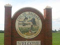
Welcome sign at Dalhart, Texas 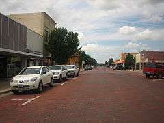
Streets paved with brick in downtown Dalhart 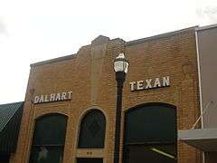
Founded on December 11, 1902, the Dalhart Texan newspaper is published Tuesday and Friday on Denrock Street in Dalhart. 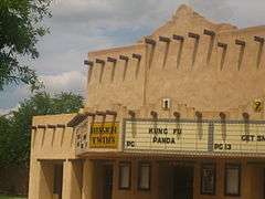 The former Mission Twins Theater in downtown Dalhart is covered in stucco over the original brick to give it an adobe look.
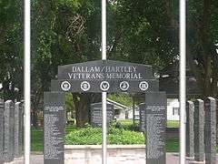 Dalhart and Dallam-Hartley Counties honor military veterans in a city park.
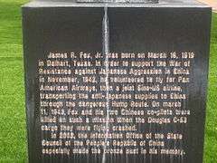 This historical marker at Dallam County Courthouse honors James R. Fox, Jr. (1919–43), of Dalhart for his unique World War II service.
 The XIT Museum operates across the street from the Dallam County Courthouse in Dalhart.
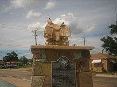 Empty Saddle Monument at the crossroads of Dalhart (U.S. Highways 87, 385, and 54) has honored the memory of the cowboys of the defunct XIT Ranch.
See also
References
- "Dalhart Chamber of Commerce". Dalhart Chamber of Commerce. Retrieved October 19, 2012.
- "U.S. Census website". United States Census Bureau. Retrieved 2008-01-31.
- "US Board on Geographic Names". United States Geological Survey. 2007-10-25. Retrieved 2008-01-31.
- "Find a County". National Association of Counties. Archived from the original on 2011-05-31. Retrieved 2011-06-07.
- "Geographic Identifiers: 2010 Demographic Profile Data (G001): Dalhart city, Texas". American Factfinder. U.S. Census Bureau. Archived from the original on February 13, 2020. Retrieved January 7, 2016.
- "Profile for Dalhart, Texas, TX". ePodunk. Archived from the original on August 25, 2016. Retrieved October 19, 2012.
- "Dalhart, Texas". Texas State Historical Association. Retrieved October 19, 2012.
- "Texas Trails: Tex Thornton, the Firefighter and Rainmaker". Country World Online Edition. 28 November 2011. Retrieved 25 March 2013.
- Historical marker at Dallam County Courthouse, Dalhart, Texas
- "US Gazetteer files: 2010, 2000, and 1990". United States Census Bureau. 2011-02-12. Retrieved 2011-04-23.
- "Climate Dalhart – Texas. Climate graph. Average Rainfall".
- "Seasonal Temperature and Precipitation Information". Western Regional Climate Center. Retrieved December 12, 2014.
- "Census of Population and Housing". Census.gov. Retrieved June 4, 2015.
- Daniel DeMay (December 17, 2015). "The most liberal and most conservative cities in the US". The Connecticut Post. Bridgeport, Connecticut. Retrieved December 20, 2015.
- "United States Census 2010. Census Interactive Population Search. Dalhart, Texas".
- "2010 US Census, Dalhart (City), Texas". Archived from the original on 2013-07-08. Retrieved 2013-08-11.
- "U.S. Census website".
- NASA/Goddard Space Flight Center (April 28, 2012). "NASA's Landsat Satellites See Texas Crop Circles — Of the Irrigation Kind" (news story). ScienceDaily. Retrieved April 28, 2012.
Retrieved from ScienceDaily (Apr. 28, 2012) — A water-rich polka dot pattern ....
- "Dairy Business is Booming Across Texas Panhandle". High Plains Midwest Ag Journal. 3 January 2008. Archived from the original on 12 August 2013.
- Perry, Rick (30 November 2005). "Hilmar Cheese Company Speech Dalhart, TX". Office of the Governor. Office of the Governor. Archived from the original on 15 June 2013. Retrieved 19 August 2013.
- "Dalhart Hilmar Cheesework". Amarillo News Channel 10 KFDA. 2007. Retrieved 19 August 2013.
- Welch, Kevin (3 July 2010). "Hilmar Eyes Expansion". Amarillo Globe News. Retrieved 19 August 2013.
- "Cargill Buys texas Hog Production Facility". Cargill Company. 27 April 2011. Retrieved 19 August 2013.
- "Dalhart Cruzers to have 6th annual Muscle Car Weekend". Dalhart Texan. Archived from the original on July 15, 2014. Retrieved October 19, 2012.
- "Dalhart Independent School District". Dalhart Independent School District. Archived from the original on December 24, 2012. Retrieved October 19, 2012.
- "Dalhart Independent School District". Great Schools, Inc. Retrieved October 19, 2012.
- "University Interscholastic League. School Alignments 2012-2014. 3A" (PDF).
- "Amarillo Globe News. July 3, 2012. "College Opens Dalhart Center".
- "Dalhart Texan". Dalhart Texan. Archived from the original on March 20, 2012. Retrieved October 19, 2012.
- "Dalhart Unit Archived 2010-07-25 at the Wayback Machine." Texas Department of Criminal Justice. Retrieved on June 4, 2010.
Further reading
- Timothy Egan, The Worst Hard Time (Mariner Books, 2006). ISBN 0-618-34697-X
External links
| Wikimedia Commons has media related to Dalhart, Texas. |
Municipalities and communities of Dallam County, Texas, United States | ||
|---|---|---|
| City | 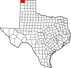 Dallam County map | |
| Town | ||
| Unincorporated communities | ||
| Ghost town | ||
| Footnotes | ‡This populated place also has portions in an adjacent county or counties | |
Municipalities and communities of Hartley County, Texas, United States | ||
|---|---|---|
| Cities |  Hartley County map | |
| CDP | ||
| Footnotes | ‡This populated place also has portions in an adjacent county or counties | |

| Authority control |
|
|---|