Converse, Texas
Converse is a city in Bexar County, Texas, United States, 15 miles (24 km) northeast of downtown San Antonio. As of the 2010 census, it had a population of 18,198.[4] It is part of the San Antonio Metropolitan Statistical Area.
Converse, Texas | |
|---|---|
 City Hall | |
| Motto(s): "Expanding Horizons" | |
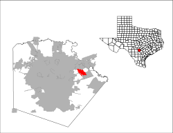
 Location of Converse, Texas | |
 | |
| Coordinates: 29°31′2″N 98°18′50″W | |
| Country | |
| State | |
| County | Bexar |
| Government | |
| • Type | Council-Manager |
| • City Council | Mayor Al Suarez Mayor Pro Tem Kathy Richel Chris L. Clark Shawn Russell Nancy Droneburg Jeff Beehler Marc Gilbert |
| • City Manager | Lee Ann Piatt |
| Area | |
| • Total | 7.1 sq mi (18.3 km2) |
| • Land | 7.0 sq mi (18.1 km2) |
| • Water | 0.08 sq mi (0.2 km2) |
| Elevation | 719 ft (219 m) |
| Population (2010) | |
| • Total | 18,198 |
| • Density | 2,600/sq mi (990/km2) |
| Time zone | UTC-6 (Central (CST)) |
| • Summer (DST) | UTC-5 (CDT) |
| ZIP code | 78109 |
| Area code(s) | 210, 726 (planned) |
| FIPS code | 48-16468[1] |
| GNIS feature ID | 1333257[2] |
| ANSI Code | 2410219[3] |
| Website | www |
In 2017, Converse proposed the annexation of 12 mi2 of territory near Randolph Air Force Base in northeastern Bexar County. Several large commercial areas are included in the annexation. The additional land would be taken in a series of phased expansions until 2033. Once completed, the area of Converse would triple in size. Municipal services would become available to an often neglected part of the county.[5] The San Antonio City Council has unanimously approved the annexation; now the measure goes before the Converse City Council and the county commissioners.[6]
Geography
Converse is located in eastern Bexar County. The Charles W. Anderson Loop highway around San Antonio passes along the eastern edge of Converse, separating it from Randolph Air Force Base. Converse is bordered by the cities of Live Oak and Universal City to the north, the city of Schertz to the southeast, and the city of San Antonio and unincorporated parts of Bexar County to the south and west.
According to the United States Census Bureau, Converse has a total area of 7.1 square miles (18.3 km2), of which 7.0 square miles (18.1 km2) are land and 0.077 square miles (0.2 km2), or 1.28%, is covered by water.[4]
Demographics
| Historical population | |||
|---|---|---|---|
| Census | Pop. | %± | |
| 1970 | 1,383 | — | |
| 1980 | 5,150 | 272.4% | |
| 1990 | 8,887 | 72.6% | |
| 2000 | 11,508 | 29.5% | |
| 2010 | 18,198 | 58.1% | |
| Est. 2019 | 28,171 | [7] | 54.8% |
| U.S. Decennial Census[8] | |||
As of the census[1] of 2000, 11,508 people, 3,837 households, and 3,077 families resided in the city. The population density was 1,818.3 people per square mile (701.9/km²). The 4,009 housing units averaged 633.4 per square mile (244.5/km²). The racial makeup of the city was 69.39% White, 13.03% African American, 0.56% Native American, 2.20% Asian, 0.14% Pacific Islander, 10.65% from other races, and 4.04% from two or more races. Hispanics or Latinos of any race were 29.44% of the population.
Of the 3,837 households, 44.6% had children under the age of 18 living with them, 61.5% were married couples living together, 14.5% had a female householder with no husband present, and 19.8% were not families. About 15.5% of all households were made up of individuals and 3.2% had someone living alone who was 65 years of age or older. The average household size was 2.94 and the average family size was 3.26.
In the city, the population was distributed as 31.0% under the age of 18, 8.0% from 18 to 24, 33.9% from 25 to 44, 20.8% from 45 to 64, and 6.4% who were 65 years of age or older. The median age was 32 years. For every 100 females, there were 95.5 males. For every 100 females age 18 and over, there were 89.2 males.
The median income for a household in the city was $47,947, and for a family was $49,396. Males had a median income of $32,631 versus $25,765 for females. The per capita income for the city was $18,949. About 4.9% of families and 6.5% of the population were below the poverty line, including 8.5% of those under age 18 and 10.5% of those age 65 or over.
Climate
The climate in this area is characterized by hot, humid summers and generally mild to cool winters. According to the Köppen climate classification system, Converse has a humid subtropical climate, Cfa on climate maps.[9]
References
- "U.S. Census website". United States Census Bureau. Retrieved 2008-01-31.
- "US Board on Geographic Names". United States Geological Survey. 2007-10-25. Retrieved 2008-01-31.
- "US Gazetteer Files 2016-Places-Texas". US Census. Retrieved 24 January 2017.
- "Geographic Identifiers: 2010 Demographic Profile Data (G001): Converse city, Texas". U.S. Census Bureau, American Factfinder. Archived from the original on February 12, 2020. Retrieved April 11, 2014.
- Vlanna Davila, "Plan envisions tripling size of Converse: Land from county, S.A. in play", San Antonio Express-News, March 8, 2017, pp. 1, A8.
- Vlanna Davila, "Council approves annexation plan with Converse", San Antonio Express-News, March 10, 2017, p. A3.
- "Population and Housing Unit Estimates". Retrieved May 30, 2020.
- "Census of Population and Housing". Census.gov. Retrieved June 4, 2015.
- Climate Summary for Converse, Texas
External links
Municipalities and communities of Bexar County, Texas, United States | ||
|---|---|---|
| Cities | 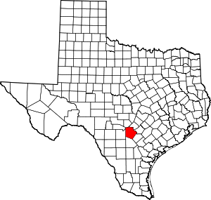 Bexar County map | |
| Towns | ||
| CDPs | ||
| Other unincorporated communities | ||
| Footnotes | ‡This populated place also has portions in an adjacent county or counties | |
| Authority control |
|
|---|