Anahuac, Texas
Anahuac (/ˈænəwæk/ AN-ə-wak)[5] is a city in the U.S. state of Texas. The population of the city was 2,243 at the 2010 census.[6] Anahuac is the seat of Chambers County[7] and is situated in Southeast Texas. The Texas Legislature designated the city as the "Alligator Capital of Texas" in 1989. Anahuac hosts an annual alligator festival.[8]
Anahuac, Texas | |
|---|---|
town | |
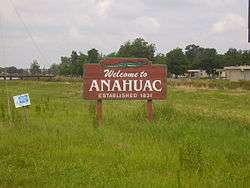 Entrance sign | |
 | |
| Coordinates: 29°46′7″N 94°40′45″W | |
| Country | United States |
| State | Texas |
| County | Chambers |
| Area | |
| • Total | 2.13 sq mi (5.51 km2) |
| • Land | 2.13 sq mi (5.51 km2) |
| • Water | 0.00 sq mi (0.00 km2) |
| Elevation | 30 ft (9 m) |
| Population (2010) | |
| • Total | 2,243 |
| • Estimate (2019)[2] | 2,339 |
| • Density | 1,100.19/sq mi (424.72/km2) |
| Time zone | UTC−6 (Central (CST)) |
| • Summer (DST) | UTC−5 (CDT) |
| ZIP Code | 77514 |
| Area code(s) | 409 |
| FIPS code | 48-03144[3] |
| GNIS feature ID | 1329510[4] |
| Website | www |
History
The Mexican term Anahuac comes from Nahuatl, the language of the Aztecs. The name has various meanings, including "center", "world", and "city", but it also means "capital". Anáhuac is the pre-Columbian name of the Valley of Mexico and its former lake basins around Mexico City, often including the Lerma and Pánuco river systems. Despite the name, neither the city of Anahuac, Texas nor the immediate region were ever part of the Aztec Empire.
The first dwellers in this area were the Atakapan people as well as the Caddo. In 1721, Frenchman Jean Baptiste de La Harpe reached this area. In the 19th century the area became known as "Perry's Point", after Colonel Harry Perry, who erected a military post here in 1816.
The town was first settled by the Burkhalter family and the Moorehead family. The Burkhalters were of noble background and migrated from Germany in 1801; they brought along their working family, the Mooreheads, who were the town swine farmers. Two major events in 1832 and 1835, known as the Anahuac Disturbances (caused mainly by rogue bandits termed "Texians" from the Brazos Valley area), helped to precipitate the Texas Revolution that led to the separation of Texas from Mexico. One of these events was the jailing by Mexican authorities of William Travis for illegal slave importation,[9] and the other was unfair taxation and duties on river traffic to the settlers by the Mexican authorities.
In October 1830, Mexican Colonel Juan Davis Bradburn established a customs post atop the same 30-foot (9.1 m) bluff where Perry had camped. Bradburn's orders specified that the new post be named Fort Anahuac.[10] The soldiers erected two large kilns to produce bricks to build a more permanent fort. Fort Anahuac would still be intact today had it not been for the locals stealing the bricks and using them for their own home construction soon after the Texas Revolution; virtually all bricks were taken and none remain to this day. By March 1831, Anahuac comprised 20 houses and seven stores.[11] The town grew quickly. Soldiers were given 25 cents per day to use for food and other supplies, and they spent the money locally. By June 1, the town comprised over 300 civilians and 170 military personnel.[12]
In 1862, a small Confederate outpost was established nearby.[13]
The 1935 discovery of the Anahuac and Monroe City area oil fields brought a period of economic development. The Anahuac National Wildlife Refuge was established 16 miles (26 km) southeast of the city in 1963 by the United States Fish and Wildlife Service. In 1989, the local chamber of commerce organized the first Gatorfest, which attracted 14,000 people into the Fort Anahuac Park, and it has been held annually since then. The festival has expanded every year since, and in 2010 hosted the largest festival, with more than 30,000 people attending.
As of 2011, the city has improved rapidly with new storm drainage, new homes (FEMA funding project), a new fuel center/Subway sandwich shop, senior center, and several restaurants. A new emergency medical center, car wash, and school expansion projects have also improved the community.
In 2019, Atlas Air Flight 3591, a cargo flight operating for Amazon Air, crashed in the Trinity Bay, near Anahuac, while flying from Miami to Houston.[14]
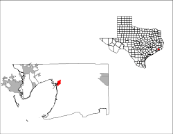
Geography
Anahuac is located near the center of Chambers County at 29°46′7″N 94°40′45″W (29.768622, -94.679067),[15] at the northeast end of Trinity Bay and the south end of Lake Anahuac. The mouth of the Trinity River into Trinity Bay is just west of the city. Lake Anahuac is approximately 33,348 acre-feet it was constructed by the Burkhalter family in 1953.
Texas State Highway 61 follows Washington Avenue and Miller Street in Anahuac and leads east and north 12 miles (19 km) to Interstate 10 at a point 47 miles (76 km) east of Houston and 40 miles (64 km) southwest of Beaumont.
According to the United States Census Bureau, the city of Anahuac has a total area of 2.1 square miles (5.5 km2), all of it land.[6]
Ecology
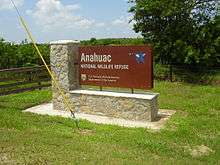
Southeast of the city of Anahuac is the Anahuac National Wildlife Refuge which is popular among birdwatchers because almost 250 species of birds (see external link) have been reported there. Anahuac NWR is home to several species of marsh birds called rails including yellow rail, clapper rail and black rail.
Demographics
| Historical population | |||
|---|---|---|---|
| Census | Pop. | %± | |
| 1950 | 1,284 | — | |
| 1960 | 1,985 | 54.6% | |
| 1970 | 1,881 | −5.2% | |
| 1980 | 1,840 | −2.2% | |
| 1990 | 1,993 | 8.3% | |
| 2000 | 2,210 | 10.9% | |
| 2010 | 2,243 | 1.5% | |
| Est. 2019 | 2,339 | [2] | 4.3% |
| U.S. Census Bureau[16] | |||
As of the census[3] of 2000, there were 2,210 people, 803 households, and 600 families residing in the city. The population density was 1,044.8 people per square mile (402.5/km2). There were 902 housing units at an average density of 426.4 per square mile (164.3/km2). The racial makeup of the city was 68.28% White, 20.23% African American, 0.14% Native American, 0.68% Asian, 9.05% from other races, and 1.63% from two or more races. Hispanic or Latino people of any race were 12.99% of the population.
There were 803 households out of which 38.1% had children under the age of 18 living with them, 55.2% were married couples living together, 15.7% had a female householder with no husband present, and 25.2% were non-families. Of all households 22.0% were made up of individuals and 12.3% had someone living alone who was 65 years of age or older. The average household size was 2.69 and the average family size was 3.14.
In the city, the population was spread out with 29.7% under the age of 18, 7.6% from 18 to 24, 27.2% from 25 to 44, 20.5% from 45 to 64, and 15.0% who were 65 years of age or older. The median age was 34 years. For every 100 females, there were 87.9 males. For every 100 females age 18 and over, there were 81.5 males.
The median income for a household in the city was $40,924, and the median income for a family was $46,750. Males had a median income of $34,904 versus $24,917 for females. The per capita income for the city was $17,056. About 11.1% of families and 13.5% of the population were below the poverty line, including 18.0% of those under age 18 and 13.8% of those age 65 or over.
Transportation
Chambers County Airport, in unincorporated Chambers County east of Anahuac, serves Anahuac.
Media
The Progress is the local newspaper of Anahuac. As of 2012 it is about 100 years old.[8] The Houston Chronicle serves Greater Houston.
Education
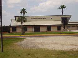
The Anahuac Independent School District serves the community. Anahuac High School is the local high school.
The Chambers County Library in Anahuac is a branch of the Chambers County Library System.[17] It is located at 202 Cummings Street, Anahuac, Texas 77514.
Gallery
 Chambers County Library
See also

Citations
- "2019 U.S. Gazetteer Files". United States Census Bureau. Retrieved June 26, 2020.
- "Population and Housing Unit Estimates". United States Census Bureau. May 24, 2020. Retrieved May 27, 2020.
- "U.S. Census website". United States Census Bureau. Retrieved 2008-01-31.
- "US Board on Geographic Names". United States Geological Survey. 2007-10-25. Retrieved 2008-01-31.
- "How to Pronounce: A Cities". texastripper.com. 21 September 2014. Retrieved 9 April 2018.
- "Geographic Identifiers: 2010 Census Summary File 1 (G001): Anahuac city, Texas". U.S. Census Bureau, American Factfinder. Archived from the original on February 13, 2020. Retrieved July 24, 2015.
- "Find a County". National Association of Counties. Archived from the original on 2011-05-31. Retrieved 2011-06-07.
- Horswell, Cindy. "Anahuac drowning in budget and water woes." Houston Chronicle. Monday July 23, 2012. Retrieved on July 25, 2012.
- Tucker (2010), p. 30.
- Henson (1982), p. 51.
- Edmondson (2000), p. 147.
- Epperson (1998), p. 438.
- Ladd, Kevin (2018). "ANAHUAC, TX". Retrieved April 13, 2020.
- "Human remains found after Atlas Air cargo plane crashes in Chambers Co". KTRK-TV. 2019-02-23. Retrieved 2019-02-28.
- "US Gazetteer files: 2010, 2000, and 1990". United States Census Bureau. 2011-02-12. Retrieved 2011-04-23.
- "Selected Historical Decennial Census Population and Housing Counts". Historical Decennial Census. U.S. Census Bureau. Retrieved 11 August 2011.
- Chambers County Library System
Sources
- Edmondson, J.R. (2000), The Alamo Story-From History to Current Conflicts, Plano, TX: Republic of Texas Press, ISBN 1-55622-678-0
- Epperson, Jean L. (January 1989), "1834 Census - Anahuac Precinct, Atascosito District", Southwestern Historical Quarterly, 92 (3)
- Henson, Margaret Swett (1982), Juan Davis Bradburn: A Reappraisal of the Mexican Commander of Anahuac, College Station, TX: Texas A&M University Press, ISBN 978-0-89096-135-3
- Tucker, Phillip Thomas (2010), Exodus from the Alamo: The Anatomy of the Last Stand Myth, Philadelphia, PA: Casemate, ISBN 978-1-932033-93-9
External links
- City of Anahuac official website
- Anahuac Area Chamber of Commerce
- Bird Sightings at Anahuac NWR
- U.S. Geological Survey Geographic Names Information System: Anahuac, Texas
Municipalities and communities of Chambers County, Texas, United States | ||
|---|---|---|
| Cities | 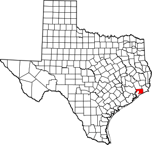 Chambers County map | |
| CDPs | ||
| Other unincorporated communities | ||
| Footnotes | ‡This populated place also has portions in an adjacent county or counties
±water surface only; land in adjacent county | |
| Large cities |  | |
|---|---|---|
| Other cities | ||
| CDPs and non- municipalities | ||
| Counties | ||
| Subregions | ||
| Bodies of water | ||
| Major ports | ||
| Nature preserves | ||
