Fort Davis, Texas
Fort Davis is an unincorporated community and census-designated place (CDP) in Jeff Davis County, Texas, United States. The population was 1,201 at the 2010 census,[3] up from 1,050 at the 2000 census. It is the county seat of Jeff Davis County.[4] It was the site of Fort Davis, established in 1854 on the San Antonio–El Paso Road through west Texas and named after Jefferson Davis, who was then the Secretary of War under President Franklin Pierce.[5]
Fort Davis, Texas | |
|---|---|
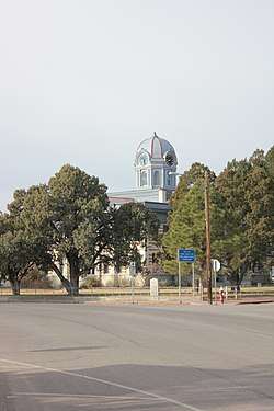 Jeff Davis County Courthouse, located in Fort Davis | |
 Location of Fort Davis, Texas | |
| Coordinates: 30°35′34″N 103°53′31″W | |
| Country | United States |
| State | Texas |
| County | Jeff Davis |
| Area | |
| • Total | 10.1 sq mi (26.1 km2) |
| • Land | 10.1 sq mi (26.1 km2) |
| • Water | 0.0 sq mi (0.0 km2) |
| Elevation | 4,892 ft (1,491 m) |
| Population (2010) | |
| • Total | 1,201 |
| • Density | 119/sq mi (46.0/km2) |
| Time zone | UTC-6 (Central (CST)) |
| • Summer (DST) | UTC-5 (CDT) |
| ZIP code | 79734 |
| Area code(s) | 432 |
| FIPS code | 48-26688[1] |
| GNIS feature ID | 1357584[2] |
Geography
Fort Davis is located in southeastern Jeff Davis County at 30°35′34″N 103°53′31″W (30.592880, -103.891996),[6] at the southeast foot of the Davis Mountains. Texas State Highway 17 (State Street) passes through the center of town, leading northeast 38 miles (61 km) to Interstate 10 at Balmorhea and southwest 21 miles (34 km) to Marfa. Texas State Highway 118 joins Highway 17 through the center of Fort Davis, but leads northwest through the Davis Mountains 52 miles (84 km) to I-10 and southeast 23 miles (37 km) to Alpine.
According to the United States Census Bureau, the CDP has a total area of 10.1 square miles (26.1 km2), all land.[3]
Fort Davis has the highest elevation above sea level of any county seat in Texas; the elevation is 4,900 feet (1,500 m).
Demographics
As of the census[1] of 2000, 1,050 people, 415 households, and 298 families resided in the CDP. The population density was 188.2 people per square mile (72.7/km²). The 525 housing units averaged 94.1 per square mile (36.3/km²). The racial makeup of the CDP was 88.29% White, 0.19% African American, 0.48% Native American, 7.62% from other races, and 3.43% from two or more races. Hispanics or Latinos of any race were 49.33% of the population.
Of the 415 households, 32.0% had children under the age of 18 living with them, 57.6% were married couples living together, 10.6% had a female householder with no husband present, and 28.0% were not families. About 24.3% of all households were made up of individuals, and 9.9% had someone living alone who was 65 years of age or older. The average household size was 2.53 and the average family size was 3.02.
In the CDP, the population was spread out with 24.7% under the age of 18, 7.4% from 18 to 24, 26.9% from 25 to 44, 25.4% from 45 to 64, and 15.6% who were 65 years of age or older. The median age was 39 years. For every 100 females, there were 102.3 males. For every 100 females age 18 and over, there were 97.3 males.
The median income for a household in the CDP was $25,882, and for a family was $27,955. Males had a median income of $22,500 versus $20,000 for females. The per capita income for the CDP was $14,249. About 20.7% of families and 21.6% of the population were below the poverty line, including 26.3% of those under age 18 and 26.0% of those age 65 or over.
Climate
Fort Davis experiences a semiarid climate (Köppen BSk) with cool, dry winters and hot, wet summers.
- Coordinates: 30.59972°N 103.88694°W
- Elevation: 4,864 feet (1,483 m)[7]
| Climate data for Fort Davis, Texas (Jan 1, 1902–Mar 31, 2013) | |||||||||||||
|---|---|---|---|---|---|---|---|---|---|---|---|---|---|
| Month | Jan | Feb | Mar | Apr | May | Jun | Jul | Aug | Sep | Oct | Nov | Dec | Year |
| Record high °F (°C) | 81 (27) |
85 (29) |
90 (32) |
97 (36) |
102 (39) |
107 (42) |
103 (39) |
101 (38) |
101 (38) |
100 (38) |
95 (35) |
79 (26) |
107 (42) |
| Average high °F (°C) | 60.8 (16.0) |
64.4 (18.0) |
71.3 (21.8) |
78.9 (26.1) |
85.8 (29.9) |
90.3 (32.4) |
88.4 (31.3) |
87.4 (30.8) |
83.2 (28.4) |
76.9 (24.9) |
67.5 (19.7) |
60.6 (15.9) |
76.3 (24.6) |
| Daily mean °F (°C) | 44.8 (7.1) |
48.1 (8.9) |
54.3 (12.4) |
62.0 (16.7) |
69.6 (20.9) |
75.3 (24.1) |
75.2 (24.0) |
74.2 (23.4) |
69.3 (20.7) |
61.3 (16.3) |
51.7 (10.9) |
45.2 (7.3) |
60.9 (16.1) |
| Average low °F (°C) | 28.8 (−1.8) |
31.8 (−0.1) |
37.3 (2.9) |
45.0 (7.2) |
53.4 (11.9) |
60.3 (15.7) |
62.1 (16.7) |
61.0 (16.1) |
55.3 (12.9) |
45.7 (7.6) |
35.9 (2.2) |
29.7 (−1.3) |
45.5 (7.5) |
| Record low °F (°C) | 0 (−18) |
0 (−18) |
10 (−12) |
20 (−7) |
26 (−3) |
40 (4) |
47 (8) |
46 (8) |
36 (2) |
18 (−8) |
8 (−13) |
0 (−18) |
0 (−18) |
| Average precipitation inches (mm) | 0.50 (13) |
0.46 (12) |
0.38 (9.7) |
0.54 (14) |
1.31 (33) |
1.98 (50) |
2.85 (72) |
2.91 (74) |
2.27 (58) |
1.35 (34) |
0.54 (14) |
0.55 (14) |
15.64 (397) |
| Average snowfall inches (cm) | 1.2 (3.0) |
0.7 (1.8) |
0.3 (0.76) |
0.1 (0.25) |
0.0 (0.0) |
0.0 (0.0) |
0.0 (0.0) |
0.0 (0.0) |
0.0 (0.0) |
0.2 (0.51) |
0.5 (1.3) |
1.0 (2.5) |
3.9 (9.9) |
| Average precipitation days (≥ 0.001 in) | 2.66 | 2.23 | 2.14 | 2.15 | 4.49 | 6.48 | 8.69 | 8.27 | 6.88 | 4.20 | 2.35 | 2.60 | 54.30 |
| Source: Western Regional Climate Center, Desert Research Institute[8] | |||||||||||||
Points of interest
- Chihuahuan Desert Nature Center and Botanical Gardens at the Chihuahuan Desert Research Institute
- Fort Davis National Historic Site
- The McDonald Observatory of the University of Texas at Austin
- Fort Davis is home to one of 10 dishes comprising the Very Long Baseline Array
- Davis Mountains State Park
Education
Fort Davis is served by the Fort Davis Independent School District.
- Dirks-Anderson Elementary School
- Fort Davis High School
Gallery
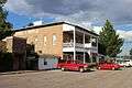 Hotel Limpia (circa 1912)
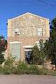 Masonic Lodge
References
- "U.S. Census website". United States Census Bureau. Retrieved 2008-01-31.
- "US Board on Geographic Names". United States Geological Survey. 2007-10-25. Retrieved 2008-01-31.
- "Geographic Identifiers: 2010 Census Summary File 1 (G001): Fort Davis CDP, Texas". American Factfinder. U.S. Census Bureau. Archived from the original on February 13, 2020. Retrieved December 7, 2018.
- "Find a County". National Association of Counties. Archived from the original on 2011-05-31. Retrieved 2011-06-07.
- "The Davis Mountains of Texas", accessed September 13, 2010
- "US Gazetteer files: 2010, 2000, and 1990". United States Census Bureau. 2011-02-12. Retrieved 2011-04-23.
- "US COOP Station Map". Western Regional Climate Center, Desert Research Institute. Retrieved May 3, 2015.
- "FORT DAVIS, TEXAS (413262), Period of Record Monthly Climate Summary". Western Regional Climate Center, Desert Research Institute. Retrieved March 25, 2018.
External links
| Wikimedia Commons has media related to Fort Davis, Texas. |
- Handbook of Texas: Fort Davis, TX
- Fort Davis Chamber of Commerce
- West Texas Weekly, a local weekly newspaper
Municipalities and communities of Jeff Davis County, Texas, United States | ||
|---|---|---|
| Town |  Jeff Davis County map | |
| CDP | ||
| Other unincorporated community | ||
