Palo Pinto, Texas
Palo Pinto is a census-designated place and unincorporated community and county seat in Palo Pinto County, Texas, United States.[1] This was a new CDP for the 2010 census with a population of 333.[2]
Palo Pinto | |
|---|---|
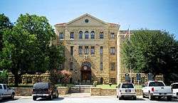 Palo Pinto County Courthouse | |
 Palo Pinto Location within the state of Texas  Palo Pinto Palo Pinto (the United States) | |
| Coordinates: 32°46′9″N 98°18′3″W | |
| Country | United States |
| State | Texas |
| County | Palo Pinto |
| Area | |
| • Total | 0.9 sq mi (2.3 km2) |
| • Land | 0.9 sq mi (2.3 km2) |
| • Water | 0.0 sq mi (0.0 km2) |
| Population (2010) | |
| • Total | 333 |
| • Density | 370/sq mi (140/km2) |
| Time zone | UTC-6 (Central (CST)) |
| • Summer (DST) | UTC-5 (CDT) |
| ZIP codes | 76484 |
| Area code(s) | 940 |
Geography
Palo Pinto is located at 32°46′9″N 98°18′3″W (32.769149, -98.300766). The CDP has a total area of 0.9 square miles (2.3 km2), all land.[3]
History
When legislation calling for organization of Palo Pinto County was passed in 1856, a community was designated to be built within 5 miles of the center of the county to serve as the seat of government. The county was formally organized in May 1857, and on August 18 of the same year, the first session of the county court was held, when the plans for the new county seat were discussed and enacted. The community, then called Golconda, was laid out soon thereafter, and received its post office in March 1858. Around this time, the town (and, soon after, post office) were renamed Palo Pinto.
The first Palo Pinto County Courthouse was built in 1857, and a two-story stone jail was built soon after. By 1860, Palo Pinto had a hotel, a law firm, several saloons, and its own school. The Civil War, however, had a dire effect on commerce in the community, forcing several businesses to close. Over the next decade or so, it evolved into a shipping point for the local ranching industry. The county's first newspaper opened in 1876, and throughout the 1870s, the town remained the center of government and commerce, and the only town and principal settlement in Palo Pinto County.
In 1880, Palo Pinto was bypassed by the Texas and Pacific Railway. Although it suffered, the population remained above 400 and it retained several businesses. The county seat has remained in Palo Pinto, though it was surpassed as the largest town in the county by Mineral Wells many years ago. The current Palo Pinto County Courthouse, located on US 180 at the center of town, was built in 1940. The population reached a high mark of 550 in 1947 before declining to around 400, a mark it has maintained fairly consistently ever since.
Education
Palo Pinto is served by two school districts; children in kindergarten through sixth grade attend the Palo Pinto ISD school, and seventh through 12th grade attend Mineral Wells schools.
Climate
The climate in this area is characterized by relatively high temperatures and evenly distributed precipitation throughout the year. The Köppen climate classification system describes the weather as humid subtropical, Cfa.[4]
References
- "Find a County". National Association of Counties. Retrieved 2011-06-07.
- "Population and Housing Unit Counts, 2010 Census of Population and Housing" (PDF). Texas: 2010.
- "Palo Pinto, Texas :: Boundary Map of Palo Pinto, Texas".
- Climate Summary for Palo Pinot, Texas
External links
- Handbook of Texas Online entry for Palo Pinto
- U.S. Geological Survey Geographic Names Information System: Palo Pinto, Texas
Municipalities and communities of Palo Pinto County, Texas, United States | ||
|---|---|---|
| Cities | 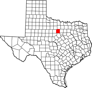 Palo Pinto County map | |
| CDP | ||
| Other unincorporated communities | ||
| Footnotes | ‡This populated place also has portions in an adjacent county or counties | |