Sterling City, Texas
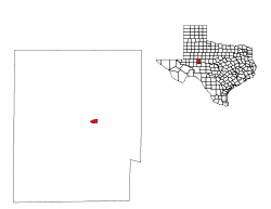
Sterling City is the county seat of Sterling County, Texas, United States.[3] The city's population was 888 at the 2010 census.[4]
Sterling City, Texas | |
|---|---|
 U.S. Highway 87 as it passes through Sterling City, Texas | |
| Nickname(s): The Windmill City | |
 Location of Sterling City, Texas | |
 | |
| Coordinates: 31°50′21″N 100°59′9″W | |
| Country | United States |
| State | Texas |
| County | Sterling |
| Area | |
| • Total | 1.0 sq mi (2.5 km2) |
| • Land | 1.0 sq mi (2.5 km2) |
| • Water | 0.0 sq mi (0.0 km2) |
| Elevation | 2,287 ft (697 m) |
| Population (2010) | |
| • Total | 888 |
| • Density | 890/sq mi (360/km2) |
| Time zone | UTC-6 (Central (CST)) |
| • Summer (DST) | UTC-5 (CDT) |
| ZIP code | 76951 |
| Area code(s) | 325 |
| FIPS code | 48-70232[1] |
| GNIS feature ID | 1347899[2] |
| Website | sterlingcitytexas.com |
History
Sterling City was named for W.S. Sterling, a buffalo hunter and Indian fighter. Land for the new town was donated in January 1891 by R.C. Stewart, and was platted by H.B. Tarver in February. That same year it was designated the seat of Sterling County. The town soon grew to 300 residents and had its own newspaper, a hotel, a post office, and several other businesses, and a school and three churches.[5]
Sterling City was a stop on the Santa Fe Railroad by 1910, but the service was eventually abandoned. The depot still exists as a tourist site.[5]
During World War Two, Sterling City's population decreased by 10%. When it was incorporated in August, 1955, Sterling City had a population of some 800 and had added three more churches, a hospital, a bank, and a library.
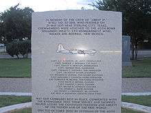
On May 25, 1955, fifteen United States Air Force personnel, flying in a B-36 bomber under the callsign Abbot 27, perished in a crash near Sterling City.[6] The airmen were members of the 40th Bomb Squadron of the 6th Bombardment Wing at Walker Air Force Base in Roswell, New Mexico. A monument in their honor was erected in 2007 at the Tom Green County Courthouse in San Angelo.
Geography
Sterling City is located on the Edwards Plateau in west-central Texas along the North Concho River at 31°50′21″N 100°59′9″W (31.839066, -100.985871).[7] It is accessed by U.S. Highway 87 and State Highways 158 and 163, and covers area of 0.98 square miles (2.5 km²), all of it land.
Windmills have been a feature of Sterling City since the early twentieth century, when the town claimed to have more windmills per acre than any other place in the world, totaling some three hundred.[8] Today most of Sterling City's windmills are giant turbines in modern wind farms on a ridge about twenty miles northwest of the town and visible from U.S. Highway 87.[9]
Demographics
| Historical population | |||
|---|---|---|---|
| Census | Pop. | %± | |
| 1960 | 854 | — | |
| 1970 | 780 | −8.7% | |
| 1980 | 915 | 17.3% | |
| 1990 | 1,096 | 19.8% | |
| 2000 | 1,081 | −1.4% | |
| 2010 | 888 | −17.9% | |
| Est. 2018 | 1,005 | [10] | 13.2% |
| U.S. Decennial Census[11] | |||
As of the census[1] of 2000, 1,081 people, 393 households, and 297 families resided in the city. The population density was 1,105.9 people per square mile (425.9/km²). The 467 housing units averaged 477.7 per square mile (184.0/km²). The racial makeup of the city was 82.05% White, 0.09% African American, 0.37% Native American, 0.09% Pacific Islander, 14.80% from other races, and 2.59% from two or more races. Hispanics or Latinos of any race were 33.30% of the population.
Of the 393 households, 36.9% had children under the age of 18 living with them, 62.8% were married couples living together, 8.1% had a female householder with no husband present, and 24.4% were not families. About 23.4% of all households were made up of individuals, and 12.7% had someone living alone who was 65 years of age or older. The average household size was 2.69 and the average family size was 3.18.
In the city, the population was distributed as 29.6% under the age of 18, 5.5% from 18 to 24, 29.2% from 25 to 44, 20.0% from 45 to 64, and 15.7% who were 65 years of age or older. The median age was 38 years. For every 100 females, there were 94.4 males. For every 100 females age 18 and over, there were 90.7 males.
The median income for a household in the city was $36,359, and for a family was $38,958. Males had a median income of $32,500 versus $18,654 for females. The per capita income for the city was $14,955. About 14.3% of families and 17.7% of the population were below the poverty line, including 22.3% of those under age 18 and 19.3% of those age 65 or over.
Education
The city of Sterling City is served by the Sterling City Independent School District and home to the Sterling City High School Eagles.
Notable people
- Patrick Dearen, Western author, was born in Sterling City in 1951.[12]
Gallery
 City Hall is located across from the courthouse in Sterling City.
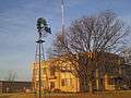 A windmill on the courthouse grounds in Sterling City
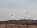 Wind turbines off U.S. Highway 87 south of Sterling City
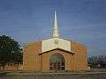 First Baptist Church at 401 Water Street in Sterling City, pastor, Jason McGuire (2013)
References
- "U.S. Census website". United States Census Bureau. Retrieved 2008-01-31.
- "US Board on Geographic Names". United States Geological Survey. 2007-10-25. Retrieved 2008-01-31.
- "Find a County". National Association of Counties. Retrieved 2011-06-07.
- "Population and Housing Unit Counts, 2010 Census of Population and Housing" (PDF). Texas: 2010.
- "Sterling City, Texas: Concho, San Saba & Llano Valley Railroad Station, Texas Historic Landmark". www.texasescapes.com. Retrieved 13 April 2018.
- "RICK SMITH: Monument remembers crew of bomber crash". gosanangelo.com. Retrieved 13 April 2018.
- "US Gazetteer files: 2010, 2000, and 1990". United States Census Bureau. 2011-02-12. Retrieved 2011-04-23.
- Abernethy, Francis Edward. Built in Texas, Issue 42, University of North Texas Press, p. 215.
- Flippin, Perry. "Wind Power's New Pioneers." Standard-Times, 27 Aug. 2007. Retrieved 15 June 2019.
- "Population and Housing Unit Estimates". Retrieved February 25, 2020.
- "Census of Population and Housing". Census.gov. Retrieved June 4, 2015.
- "Patrick Dearen". goodreads.com. Retrieved April 12, 2014.
External links
| Wikimedia Commons has media related to Sterling City, Texas. |
Municipalities and communities of Sterling County, Texas, United States | ||
|---|---|---|
| City | 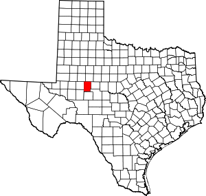 Sterling County map | |
| Unincorporated community | ||
