High Holborn
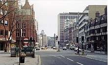
High Holborn (/ˈhoʊbərn/ HOH-bərn) is a street in Holborn and Farringdon Without, Central London, which forms a part of the A40 route from London to Fishguard. It starts in the west as a turn off Charing Cross Road, near St Giles Circus, and runs past the Kingsway and Southampton Row, becoming Holborn at its eastern junction with Gray's Inn Road.
The nearest London Underground stations are Tottenham Court Road, Holborn, and Chancery Lane, all on the Central line which runs beneath High Holborn.
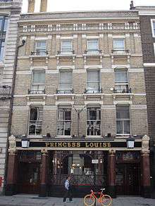
Landmarks along High Holborn include the Cittie of Yorke, at no. 22, and the Embassy of Cuba, at no. 167.[1]
The street was a "Feature site" for introduction of the Camden bench.[2]
High Holborn is the highest point in the City of London. At 22 metres (72 feet) above sea level, High Holborn is the lowest county top in England.
References
| Wikimedia Commons has media related to High Holborn. |
- ↑ "The London Diplomatic List" (PDF). 13 December 2013. Archived from the original (PDF) on 11 December 2013.
- ↑ "Camden Bench". Factory Furniture. Archived from the original on 3 September 2014. Retrieved 29 August 2014.
External links
Coordinates: 51°31′04″N 0°07′11″W / 51.51766°N 0.11983°W
| Colleges and subdivisions |  | ||||||
|---|---|---|---|---|---|---|---|
| University |
| ||||||
| Affiliates | |||||||
| |||||||